Fun, swells into the end of the week and weekend, plenty of action next week

Victoria Forecast by Craig Brokensha (issued Monday 29th July)
Best Days: Surf Coast Friday, Saturday morning, Sunday, Monday, Wednesday onwards
Recap
Poor conditions with a fresh to strong onshore wind and mix of swells yesterday, improving across all locations today with lighter and more variable winds. We're expected to see winds go offshore from the N across most locations this morning and then remaining variable into the afternoon. A mix of easing long-range W/SW and S/SW groundswells are easing.
Today’s Forecaster Notes are brought to you by Rip Curl
This week and weekend (Aug 1 - 4)
Tomorrow looks like a lay day as the surf continues to ease leaving small 1-2ft waves on the Surf Coast and 3ft sets to the east under a moderate morning W/NW offshore. Winds will shift W/SW-SW into the afternoon, so if you're desperate for a surf, get out before lunch.
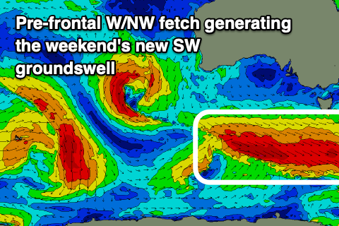
Our mix of long-period W/SW and SW groundswells for Friday is still on track, with an additional small SW groundswell now due to be in the mix. These swells are being generated by the one system, with the W/SW energy produced by a pre-frontal fetch of severe-gale W/NW winds. The post-frontal fetch linked to the SW swell looks weaker now and not as favourable, while a very tight and intense low spawning off this post-frontal fetch will produce a burst of severe-gale W/SW winds briefly in our south-western swell window early tomorrow morning.
All these swells will fill in Friday, and come in between 3-4ft on the sets across the Surf Coast and 5-6ft on the Mornington Peninsula. Winds will be best for protected spots with onshore SW breezes across locations east of Melbourne, and a W/NW breeze on the Surf Coast, swinging W/SW into the afternoon.
 The swells should ease back into Saturday morning temporarily ahead of a new SW groundswell building into the afternoon, easing Sunday.
The source of this swell will be a strengthening polar storm south-west of Tassie tomorrow evening, but most of the action will be pre-frontal with not much post-frontal activity now due in our southern swell window, linked to a possible S/SW swell for Sunday.
We'll see a great pre-frontal fetch of elongated W/NW gales generated in our swell window Friday, producing a good SW groundswell for us Saturday afternoon, building back to 3-4ft on the sets across the Surf Coast later in the afternoon and 5-6ft on the Mornington Peninsula. Sunday will then see the surf easing back from 3ft+ and 5ft respectively.
Winds on Saturday will be good in the morning and out of the W/NW, shifting W/SW-SW into the afternoon, great all day Sunday as the swell eases and from the NW (possibly tending lighter N/NW late east of Melbourne).
The swell will continue to ease into Monday as winds freshen from the N/NW.
Moving into next week, a small mid-latitude low moving through Tuesday will kick up a mid-period W/SW swell, for the afternoon, but of greater importance is the activity behind this, with a much stronger and broader frontal progression forecast to move in and under the country.
This may deepen significantly while moving across us later in the week, bringing large and windy surf best suited to protected spots and more snow to the mountains. More on this in Friday's update though.
Comments
This winter has been very average for L to XL swells and snow srorms for the mointains so far! I assume this is because the Southern Annular Mode has been quite benign and more neutral so far this winter and late next week looks to break this trend and become a stronger negative SAM?
Can't wait to ride some powder.
Yeah the AAO forecast for next week is very strong negative, so the westerlies will be shunted north..
Thanks for sharing :) looking good!
Those northerly winds kicked in..
Should be plenty of waves around again through the period
Just book your ferry ticket now nick.
Hey Craig just thinking about my options for a am or pm surf tomorrow...
Monday's notes you said swell will arrive Thursday night and peak Friday morning and yesterdays notes said it would be building through the day Friday (inferring a later pm peak). Could you please clarify?
Cheers
I'm thinking a peak in size and consistency tomorrow morning now. Winds are a little suss but hopefully W/NW early around the Torquay region.
Also the ASCAT readings from that tight and intense low are impressive :o Could be a few sneaker sets.
Cheers Craig for timly response. Appreciate your work!
Bit far away craig but do you think the potential for surf on the 14th 15th of august is looking good for surf coast? Coming down to snowboard and was hoping to get a few days surf in beforehand. Dunno if that long wave trough will be in a good phase for swell/winds
Cheers
Nice sharp spike in Sorrel bouy this arvo, looking good!