Slow increase in size into the end of the week, larger swell next week

Victoria Forecast by Craig Brokensha (issued Wednesday 26th June)
Best Days: Exposed beaches Friday, Saturday select locations through the day working the winds, Sunday morning Surf Coast, Tuesday and Wednesday AM Surf Coast
Recap
Small to tiny surf across the coast yesterday and today with great conditions, best to the east with inconsistent 2ft sets.
Today’s Forecaster Notes are brought to you by Rip Curl
This week and next (Jun 27 - Jul 5)
We'll see similar conditions tomorrow morning across all coasts with clean 1-1.5ft waves on the Surf Coast and 2ft waves to the east under moderate to fresh N'ly tending N/NE winds.
Later in the day the first pulse of inconsistent W/SW groundswell generated off the significant and slow moving frontal progression in the southern Indian Ocean might be seen on the exposed beaches, but Friday will see the swell proper fill in.
Keep your expectations low but we'll be seeing infrequent sets around 2ft on the Surf Coast and 3-4ft+ to the east. With winds fresh to strong from the N'th, conditions will be best on the exposed beaches but possibly a little wind affected at times.
Our secondary slightly stronger but more westerly angled swell for Saturday is still on track. The swell may be seen again late in the day Friday, but Saturday is due to offer the most noticeable size. With the westerly direction the Surf Coast will be extremely inconsistent with waves mostly to 3ft on the magnets. The Mornington Peninsula looks bigger and to 5ft, if not for the rare bigger cleanup and winds will be tricky with a strong morning N'ly, shifting NW into the afternoon.
The swell will then ease off into Sunday with a mix of mid-period W/SW and S/SW swells in the mix from weaker storm activity in our swells windows over the coming days.
The Surf Coast should hopefully still see 2-3ft sets on the magnets Sunday morning, easing into the afternoon, with surf easing from 4-5ft on the Mornington Peninsula.
W/NW-NW winds will persist all day, favouring the Surf Coast, more N/NW on Monday as the size continues to drop.
Moving into the middle of the week and as touched on last update, a node of the Long Wave Trough will move in from the west, bringing with it a flurry of strong frontal activity closer to us and under the country.
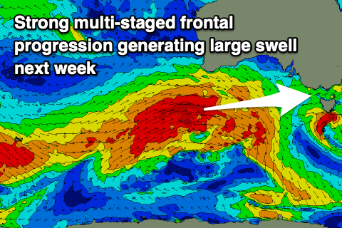 An initial polar front developing just east of Heard Island will project a fetch of severe-gale W/SW winds up towards Western Australia, through our western swell window, continuing slowly east with multiple intensifications over the weekend. The progression will broaden and break up a little under the country on Monday, with a weaker mid-latitude low possibly forming as the progression continues east across us.
We should see a large W/SW groundswell building Tuesday, peaking later in the afternoon/overnight with a reinforcing similar sized pulse for Wednesday.
Size wise we're currently looking at surf in the 5-6ft range on the Surf Coast magnets Tuesday afternoon and Wednesday, with 8ft+ waves to the east. Winds are tricky with the possible mid-latitude low forming but the latest updates have a NW tending W/NW breeze Tuesday, creating great conditions in protected spots, and more W-SW on Wednesday. We'll have a closer look at this on Friday.