Good couple of days in protected spots

Victorian Forecast by Craig Brokensha (issued Monday 18th February)
Best Days: Protected spots Tuesday and Wednesday mornings, dawn Thursday Surf Coast, beaches on the weekend
Recap
Fun waves across the beaches on Saturday with light enough winds to create clean conditions and a bit of size leftover to 2-3ft on the Surf Coast and 3-5ft on the Mornington Peninsula.
Yesterday was even better with a touch less size but great winds all day for the beaches. This morning the swell has faded further with average winds.
Today’s Forecaster Notes are brought to you by Rip Curl
This week and weekend (Feb 19 - 24)
A low point in swell is being seen today but our good new groundswell for tomorrow is on track, and winds are also looking much better than was expected late last week.
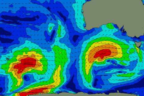 Over the past couple of days a strong and slow moving low has been projecting a fetch of W/SW-SW gales towards us (right), producing a swell which won’t be a true SW direction or either a true W/SW direction. It will fall somewhere in between and should peak tomorrow morning to 4ft to likely 5ft on the Surf Coast swell magnets and 6-8ft on the Mornington Peninsula.
Conditions are looking great for protected spots with a W/NW offshore, shifting SW later morning, with similar winds Wednesday, likely lasting a couple of hours longer from the offshore W/NW direction.
The swell will be on a slow easing trend, helped by a small embedded low generating a burst of strong to gale-force SW winds directly south-west of us this afternoon and evening. The Surf Coast should still be around 3-4ft Wednesday morning, with 5-6ft+ sets to the east.
A temporary low point in swell is expected Thursday morning and winds will be onshore out of the SW, if not for a dawn W’ly around Torquay. A new mid-period W/SW swell should build through the day, generated by a relatively weak mid-latitude front pushing in from the south-east Indian Ocean.
This was actually associated with a stronger distant storm over the weekend, producing very inconsistent long-period energy for Friday afternoon and Saturday morning, but coming back to Thursday and the Surf Coast should build back to an easy 3ft, with 4-5ft+ sets to the east, peaking Friday to a similar if not slightly bigger size. Winds are an issue though and look to be onshore out of the S/SE, better for the beaches Saturday morning and out of the E.
The swell will become small into Sunday but conditions will be even better for the beaches as winds tend NE, so aim for the magnets.
Longer term there’s nothing significant on the cards for early next week as a strong blocking high moves in from the west, but this could easily change as the models diverge on the movements of Tropical Cyclone Oma in the Coral Sea, so check back here Wednesday for more on this.
Comments
Some size about but fat burgers unfortunately.
What do you mean when you refer to the magnets?
Fisho's!
More fat, sectiony random lumps before it went proper onshore. While there's often a land breeze on the coast these type of mornings you can be sure it's blowing S/W out in Bass Strait. But yeah.....truck on down for the dawny and fill those car parks everyone.