Poor weekend, with a better outlook for next week

Victoria Forecast by Craig Brokensha (issued Friday 21st December)
Best Days: Both coasts Monday and Tuesday morning, beaches Thursday morning and Friday
Recap
Small to tiny surf and onshore winds yesterday (lighter in some regions early), while today we've got a bit more size with an increase in windswell and small groundswell but with messier conditions.
Today’s Forecaster Notes are brought to you by Rip Curl
This weekend and next week (Nov 22 - 28)
There's been no change to the weekned's forecast, and as expected (but not hoped for) the swell for early next week has been downgraded a touch more.
We've got more of the same due tomorrow with moderate to fresh but easing S/SW winds, though only small easing 2ft waves on the Surf Coast, 3ft to possibly 4ft to the east.
Sunday is still looking clean on the Surf Coast and a morning W/NW breeze, but the surf will be tiny and only likely 1-1.5ft at magnets.
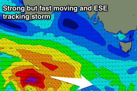 Moving onto our new SW groundswell for Monday/Tuesday and a strengthening frontal system that's currently developing south-west of WA will generate a good fetch of pre-frontal W/NW gales through our western swell window, followed by a tighter fetch of severe-gale W'ly winds, dipping quickly east-southeast through our south-western swell window.
This fast track away from our swell window isn't ideal at all, and with this I've lowered expectations from this swell a little more from Wednesday unfortunately.
The one positive from all of this though is that local winds on Tuesday (Christmas Day) are looking better for more locations.
So size wise, Monday morning will start small and likely 1-2ft on the Surf Coast, with 3ft sets to the east under a light to moderate N/NE breeze, tending N/NW later morning ahead of afternoon sea breezes. The swell is due to arrive mid-morning and build to 3ft on the Surf Coast into the afternoon, and 4-5ft+ on the Mornington Peninsula.
The swell will ease into Tuesday from a similar if not slightly smaller size but winds look good and locally offshore across both coasts early (N/NW Surf Coast and N/NE Mornington Peninsula) before a shallow change moves through.
Wednesday will be smaller, though into the afternoon a small reinforcing mid-period W/SW swell is expected, generated by a broad fetch of strong W/SW winds projecting up and under the Bight Sunday and Monday.
Winds will unfortunately be onshore and out of the S/SE on Wednesday in the wake of Tuesday's change, with better E/NE winds likely Thursday. Size wise the Surf Coast only looks to offer easing 2ft+ surf, with 3-4ft sets to the east.
Longer term there's nothing too significant into next weekend, with some possible new W/SW swell into the New Year, but more on this Monday. Have a great weekend!