Small windy period ahead; Monday the pick of the period

Victoria Forecast by Ben Matson (issued Wednesday 27th June)
Best Days: Thurs: small clean surf east of Melbourne. Sun: small windy surf west of Melbourne. Mon: better surf west of Melbourne with moderate NW winds.
Recap: Wave heights have remained small with mainly light winds across the region.
Today’s Forecaster Notes are brought to you by Rip Curl
This week (Jun 26 - 29)
Want to receive an email when these Forecaster Notes are updated? Then log in here and update your preferences.
Note: Today’s Forecaster Notes will be brief, as Craig is away on annual leave. Also, these Forecaster Notes will be updated Tuesdays, Thursdays and Saturdays for the next few weeks.
Not much surf is expected for the next few days.
There are no significant swell sources in our swell windows, so with wave heights best suited to the open beaches east of Melbourne, surfing prospects will hinge around the local winds - of which Thursday is the pick under a light NE breeze, and size around the 2-3ft+ mark though very inconsistent.
Strengthening N/NW tending NW on Friday will create problems at exposed spots.
This weekend (June 30 - July 1)
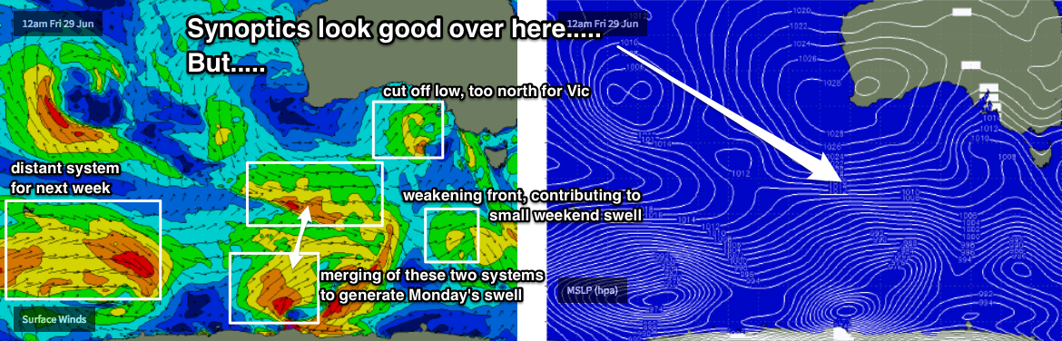
A series of weak, poorly consolidated fronts and lows will transit through our swell window this week (see chart below), and an associated series of modest though scattered fetches won’t generate a great deal of new swell for us.
The synoptic chart looks good in single snapshots, but unfortunately for us the broader picture isn’t in sync and this will maintain low wave heights across the Surf Coast, which is the only region that’ll truly benefit from this airstream.
Starting off with slow with 1-2ft waves early Saturday, size should lift into the 2ft+ range west of Melbourne into the afternoon, holding 2ft to maybe 2-3ft on Sunday, though it’ll be very lacklustre and inconsistent with extremely long breaks between likely single wave sets.
East of Melbourne will be bigger but there won’t be anywhere handling these conditions.
Next week (July 2 onwards)
The most promising part of this weather progression is probably the interaction between a polar low and a pre-frontal W/NW flow to its north, positioned S/SW of WA on Thurs/Fri (see chart above). This should provide a slightly better kick in groundswell for Monday with inconsistent sets in the 2-3ft+ range in Torquay. Winds will veer to the NW as an unrelated system approaches for the west, so conditions will be clean.
Unfortunately it’s likely to be a poor swell/wind combo for most breaks east of Melbourne.
A series of strong fronts through the Southern Ocean SW of WA around this time will then set up more swell for the middle to later part of the week. Once again, the synoptic setup isn’t favourable with unusual meridional alignments through the swell window, and for the most part the majority of swell generation looks like it’ll occur west of western SA longitudes (so, far away enough to have an impact on surf size).
That being said, there’s been quite a few variations in the model guidance over the last few days so chances are reasonable that we’ll see things swing in our favour over future updates. And with local westerly winds it’s looking like an extended run best suited to the Surf Coast. Let’s take a closer look on Friday.
Comments
Fog has been pretty thick here. What causes this? NE airflow and lots of moisture on the ground? Or the classic temperature inversion? Has the fog been on the other side of the bay as well?