Moderate west swell all weekend, larger early Monday

Victoria Forecast by Craig Brokensha (issued Friday 4th August)
Best Days: Surf Coast swell magnets all weekend, early Monday Surf Coast, Tuesday Surf Coast, east of Melbourne Thursday
Recap
Fun waves across both coasts yesterday with the tricky troughy weather resulting in light winds most of the day on the Surf Coast with clean 3ft waves on the beaches, while the Mornington Peninsula offered solid 4-5ft sets.
Today the wind has shifted to the NW favouring the Surf Coast over locations to the east as a mix of inconsistent W/SW groundswell and SE windswell provided 3ft sets. Conditions should remain good all day as the swell hangs in there.
This weekend and next week (Aug 5 - 11)
Wave heights should steady into tomorrow morning as we continue to see inconsistent levels of W/SW groundswell energy across the coast. This was generate by an elongated fetch of pre-frontal W/NW winds moving in from the Indian Ocean earlier this week.
A broad post-frontal fetch has also generated some inconsistent swell for the afternoon and Sunday morning.
In general the Surf Coast should hang in around 3ft on the sets through tomorrow with 4-6ft waves on the Mornington Peninsula, and an afternoon's increase in W'ly windswell isn't due to any major size any more. This is due to a front passing across us being a bit weaker than forecast Wednesday.
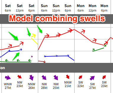 Our models are incorrectly combining the distant long-period energy with the W'ly windswell and over-forecasting the size into the afternoon and Sunday.
Sunday should reveal similar sized surf on both coasts most of the day, with a new strong long-period W/SW groundswell not really expected until on dark and more likely into the evening.
The frontal system linked to this swell is looking a bit stronger now, but it will move north of our swell window a little quicker.
With this in mind there's no real change to the expected size, with swell magnets on the Surf Coast due to come in around 4-5ft early Monday, easing through the day with 8ft sets on the Mornington Peninsula.
Winds over the weekend will be best for the Surf Coast with a fresh W/NW tending NW breeze, more gusty from the NW Sunday.
 The timing of a change linked to the mid-latitude storm generating Monday morning's swell is crucial and it looks to be just after dawn. Ahead of the change W/NW offshores are due, with SW breezes behind it. So keep an eye on the local observations west of us for any stalling of the change and a window of good conditions across the Surf Coast.
The change will bring with it an increase in S/SW windswell for the afternoon and Tuesday with winds returning back to the W/NW.
There's no major size due with easing 3ft sets on the Surf Coast and 5ft waves on the Mornington Peninsula.
Longer term there's nothing significant on the cards until later in the week/weekend when some new W/SW swell may be seen. Winds will swing to the north though favouring exposed beaches Thursday. More on this Monday. Have a great weekend!
Comments
Might want to add the term, "very inconsistent" at least a few times in that report.
Yep pretty inconsistent, but OK when they come through. Seem to be one-wave sets though.
Feel sorry for forecasters for this swell. It's a really tough one to put a size on it. My Very Inconsistent call was based on severe westerly angle and swell period of 18+ seconds. Reckon you may be overcalling Monday, but when lows move right over the top of us, the Vicco coast could get a pleasant surprise.
That's called "hedging your bets". C'mon, why not put a size on it?
On another note, I gotta say I'm surprised to see your sorrow for the forecasting community. But it's a welcome change.
How did Craig's call stack up for today?
I wouldn't be putting a size on it and neither should you guys considering how unpredictable the weather pattern is. BOM is calling for gale force offshores. That alone makes height predictions dubious at best. This looks like a really fragile swell that's not going to handle high tides, strong offshores, and slight change in directions. Come back with a report shortly.
Haha!
"We have decided not to estimate the surf size this weekend, given how unpredictable the weather pattern is".
Yeah, that'll fly. Would love to see the BOM roll that one out too.
BTW, the strength of the local offshore wind has nothing to do with the size of the surf.
Surf Report. Chest high on JJ beach and points. Head high winks and Bells. Inconsistent.
"BTW, the strength of the local offshore wind has nothing to do with the size of the surf." Really Ben. Do you seriously believe that?
Yes, I believe the science.
"The effect of opposing winds or wave energy on propagating swell is surprisingly small, especially if swell steepness is small. If a swell moving north encounters a north wind and waves moving south, only negligible changes in swell height and period will occur. The wave interactions between the swell and opposing waves are so small that errors associated with neglecting them are much smaller than errors that result from poorly defined wind speeds. These effects are, for the most part, ignored in wave/swell computations."
Source: MetEd department of NCAR, "a federally funded research and development center sponsored by the National Science Foundation and devoted to service, research and education in the atmospheric and related sciences. NCAR is managed by the nonprofit University Corporation for Atmospheric Research, a consortium of more than 100 universities granting degrees in atmospheric and related science."
Just out of curiosity, why is that? Simply because swell has more energy in it than a wind?
Could a 40knot offshore squash a short period swell coming in from the opposite direction (i.e Home. Strong North with short period SW swell?)
So last weekend when the swell came in a day later than you predicted had nothing to do with the howling offshores? And howling winds wrapping around a low don't effect swell direction at all?
I may not go in for all that book learning, but I'm just smart enough to know that swells can be kept out to sea on the Surf Coast by 70-90km northerlies. But hey 20 + years of watching the waves down here counts for nothing eh?
was "vic local" smart enough to invest in the property market 20 years ago down there….
Yes. pigdog. So technically I'm still a blow in.
Hey Ben, what are the contributing factors to swell decay over any given distance? From my understanding decay is quite complex and so a constant is applied as there are many, but only minor, impacts. But that is in the open ocean. As a wave stands up, and as you've highlighted above, steepness is likely to impact this. I'm not arguing with the science just trying to get a better understanding of nearshore.
Also, why does the opposite apply when a storm moves over an already agitated sea state?
I'll side with Ben, using the logic that wind doesn't travel under water, can't see how it could affect a good groundswell.
Also, my observations from the surfcoast on a howling NW make me think there are significant impacts near shore. Bass straight is shallow and waves will begin steepen up a long way out from shore. They tend to feel much weaker in this scenario. But maybe that's just because of the wind pushing strongly up the face?
I know the theory and science says swells can't be affected by strong offshore's, or even blown in by an onshore.
But in my experience i swear it happens.
And at some spots in a strong offshore waves often feel like they have lost energy compared to the same swell period with a light offshore or light onshore or no wind, IMO the effect is worse the lower the swell period.
You don't think it's the low period swell making it feel like the waves don't have much energy?
Agree with ID a exceptionally strong offshore tends to feel as if the power of the wave has been diminished. Wonder if the research ThermalBen referred to was researched well offshore.
I think there's pretty good anecdotal evidence that a very strong offshore will keep a swell out or significantly delay the arrival of a swell. How often do you see a swell build from flat in gale force northerlies or NWers?
I'm happy to discuss and debate the specifics, but you have to be very careful argueing anecdotal evidence against emperical data collection.
There are complex, valid reasons why swell events appear late, or end up smaller (or bigger) than expected. The main reason is because weather forecasting as a general service is very hard. Secondly, because marine forecasting has almost no observational data to work with, and thirdly because surf forecasting (a third generational forecast product) can see large variations in size between small stretches of coast, related to incremental changes in period and direction. So a swell event across a small stretch of coast can be spot on at one location and completely wrong at a neighbouring break.
And lastly, surf forecasting is also unique in that we are forecasting "good" or "bad" surf days - not neccesarily a measure of wave heights, but more related to whether someone has a good session or not. So even if the surf forecast is correct, the perception of the surf conditions via the end user (and thus the perceived accuracy of the forecast) is also related to external influences like crowds, sand banks, tides, bluebottles, etc.
So, for example, VL: what is your starting point when you say "a very strong offshore will keep a swell out or significantly delay the arrival of a swell"?
What's the evidence you have that the swell would have arrived, had there not been strong offshore winds?
BTW, this is all best done in a seperate forum thread. I might transfer over the comments there sometime today to keep it seperate. This is a great discussion which I'd like to continue.
OK, comments thread re: offshore winds and surf size are transferred here: https://www.swellnet.com/forums/crystal-ball/357613
If you could direct the convo that way it'd be great. Let's keep these Forecaster Notes for general observations about the weekend's waves. Thanks!
Nice options at 13th this AM, though TQ is bloody inconsistent - seems to be between pulses.
Hey Ben any update on the expected arrival of the new swell?
Which swell? I ain't doing Vic forecasts so haven't been looking at Southern Ocean charts - so I am not up to speed. Craig is on the road this weekend (again, for a change) so he can't update until Monday.
no worries Ben
3.45am Monday. Do you want an exact size with that as well? Maybe a lift to Bells and Ben can wax up your board also? Geez oiley give Swellnet a break. This aint Indonesia with a huge swell window, 5000km of open ocean with no blocking areas.
Any reports from the reefs?
Some nice sized sets moving through TQ Point this morning looking 3ft+.
With the west in the swell I'd expect Bells/Winki to be 4-5ft on the sets?