Pumping Surf Coast Thursday, other options for the weekend

Victoria Forecast by Craig Brokensha (issued Wednesday 28th June)
Best Days: Surf Coast Thursday, both regions Friday through the weekend, Surf Coast Monday and Tuesday morning
Recap
Another pumping day of waves across the Surf Coast yesterday with clean 3-5ft surf all day, dropping back a little today more to the 3ft range with the odd bigger set on the reefs. The Mornington Peninsula was clean all day yesterday but a little too large for the beaches, while this morning the low tide is spoiling another straight clean morning.
Winds will swing more westerly this afternoon, creating average conditions as the tide fills in while keeping the Surf Coast clean.
This week and weekend (June 29 – Jul 2)
Satellite observations look great regarding the storm responsible for tomorrow's new long-period SW groundswell. A fetch of severe-gale W/SW winds were generated south of WA on Monday with core wind speeds hitting the 50kt range.
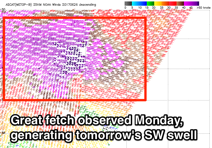 This should generate strong but inconsistent 4-5ft sets across swell magnets on the Surf Coast tomorrow morning with 6ft to occasionally 8ft waves on the Mornington Peninsula.
A fresh W/NW wind will favour the Surf Coast reefs most of the day ahead of a late afternoon S/SW change.
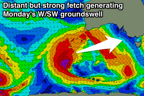
This change is linked to a strong polar front projecting north-east towards us from the Southern Ocean, developing last night south of WA again. This frontal system will be weaker though and only generate strong SW winds, producing a mid-period SW swell for Friday.
This looks to come in around 4-5ft on the Surf Coast and 6ft to occasionally 8ft on the Mornington Peninsula again through the morning but with less strength than tomorrow's swell.
Conditions aren't looking as favourable with overnight onshore winds due to tend variable through the morning and remain so all day, creating clean but lumpy conditions. The afternoon will likely be best with the light winds through the morning ironing out overnight lumpiness.
Into the weekend we'll see the mid-period SW swell easing from 3-4ft on the Surf Coast and 5-6ft on the Mornington Peninsula with N/NW tending variable winds on the Surf Coast and N/NE-N winds east of Melbourne.
Fresh N'ly winds will favour the beaches on the Surf Coast and beaches east of Melbourne Sunday and we'll see a smallish W/SW groundswell filling in, produced by a strong pre-frontal fetch of W/NW winds ahead of a much stronger polar frontal progression later this week.
 This should keep swell magnets on the Surf Coast coming in at 2-3ft, with 4-5ft waves to the east.
Of greater importance is the W/SW groundswell due off the more significant polar frontal progression Monday.
This system will form in our far western swell window which isn't ideal, but we'll see a fetch of gale to severe-gale W/SW winds generating a moderate sized W/SW groundswell for Monday.
The swell is expected to peak during the middle of the day to an inconsistent 3ft to possibly 4ft at magnets on the Surf Coast and a better 6ft+ on the Mornington Peninsula but with strong N/NW winds. This will create tricky conditions across the state.
Weaker W/NW winds are expected as the swell eases Tuesday as the progression forms into a broad weak low, too north for us to generate swell.
Longer term average W/SW windswell is on the cards once the low passes us, but more on this Friday.