Fun options from Friday, more activity next week

Victoria Forecast by Craig Brokensha (issued Wednesday 22nd March)
Best Days: East of Melbourne Friday morning, magnets Saturday and Sunday mornings, both coasts Monday morning
Recap
Not the best conditions yesterday with an easing inconsistent W/SW groundswell and light to moderate onshore winds, freshening through the day.
Today is terrible with stronger SE breezes and a poor mix of SE windswell and smaller W/SW groundswell.
This week and weekend (Mar 23 – 26)
Later today, a strong new SW groundswell should start to show across the coast, though it will be hard to distinguish under the SE windswell signal.
This swell, produced by a strong polar low over the weekend and Monday, should peak tomorrow morning to 3ft on the Surf Coast, with 4ft sets possible at magnets, and 5-6ft on the Mornington Peninsula.
Unfortunately a low off Tassie's East Coast will see fresh and gusty E/SE winds persisting through tomorrow, along with some smaller junky SE windswell.
The swell is due to ease through the afternoon, further from 2ft+ on the Surf Coast Friday and the 4ft range on the Mornington Peninsula.
The low in the Tasman Sea should start drifting east through the end of the week, resulting in winds tending more E'ly Friday morning, creating fun peaky options east of Melbourne.
Cleaner conditions will develop over the weekend with light local offshore winds Saturday morning, more variable Sunday morning.
Two new SW groundswells are due over the weekend from pre-frontal W/NW fetches moving along the polar shelf south of WA.
The first pulse for Saturday morning should provide inconsistent 2ft sets on the Surf Coast (3-4ft Mornington Peninsula), with the second for Sunday coming in just a touch bigger.
With the favourable winds each morning there should be some fun options across magnets on both coasts through the weekend.
 Next week onwards (Mar 27 onwards)
Later Sunday and more so Monday morning a very inconsistent W/SW groundswell is due from a strong storm that fired up in the southern Indian Ocean. The models seem to be incorrectly combining this swell with the existing SW energy, and we're only due to see 2ft+ waves on the Surf Coast and 3-5ft waves on the Mornington Peninsula with N'ly offshores.
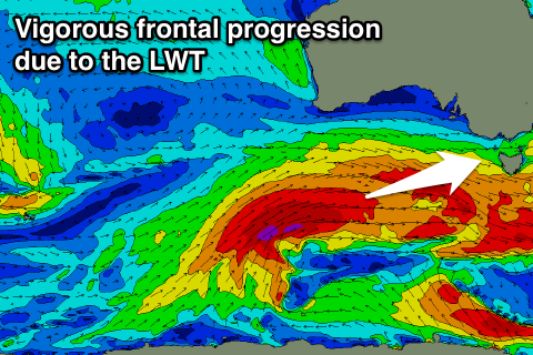
Now, as talked about Monday, the outlook for next week is a lot more active owing to a strong node of the Long Wave Trough propagating west across the country.
This will direct at least two vigorous frontal systems through our western swell window from south-west of WA Sunday through mid-next week.
Moderate to large W/SW groundswell energy will result, the first pulse for Tuesday/Wednesday with a secondary larger increase Thursday afternoon/Friday. Winds look to be from the western quadrant, but more on the timing, sizes and local winds Friday.