Forget the weekend: we've got a large groundswell due Wednesday

Victoria Forecast by Ben Matson (issued Friday 14th October)
Best Days: Sat: small clean beachies east of Melbourne. Wed: large swell with great winds for the Surf Coast and Western Port. Thurs: strong, easing swell with strengthening N'ly winds. Fri/Sat: renewal of groundswell with probably good winds for the Surf Coast and Western Port again.
Recap: Easing swells over the last few days produced reasonable surf in Torquay on Thursday despite the presence of a light to moderate onshore wind. Today we’ve got smaller surf with straight N’ly winds that are favouring all of the open beaches.
This weekend (Oct 15 - 16)
Nothing great is expected this weekend.
The storm track is focused away from our region so we’re looking at continuation of small surf, and an approaching front through the Bight will strengthen northerly winds on Saturday ahead of a NW tending W/NW flow through Sunday.
Model guidance has a series of very small W/SW pulses through Bass Strait however they have originated a very long distance from the mainland (southern Indian Ocean) and have a lot of west in their direction, so we won’t see much size across the region.
Expect slow, inconsistent 1ft to maybe 1-2ft surf at exposed beaches both days west of Melbourne, up to 2-3ft east of Melbourne.
Saturday is however the pick with the best winds, aim for the most exposed beach you can think of for the greatest size potential.
Next week onwards (Oct 17 onwards)
The weekend’s front through the Bight will largely dissipate across South Australia, leaving us with small swells and light NW winds to start next week.
However, an intense polar low currently forming SE of Madagascar is expected to strengthen considerably over the weekend as it tracks past Heard Island, enroute through the Southern Ocean beneath Australia. By Monday this system is expected to encompass much of the Southern Ocean waters beneath the continent, and whilst core winds will have weakened from Saturday’s peak (40-50kts), the broadening width of the fetch and its ideal alignment within our swell window means we’ve got an excellent groundswell due to arrive mid-week.
Tuesday looks like it’ll mainly see small conditions with freshening NW winds ahead of an afternoon W’ly change. Current model guidance has the leading edge of this new groundswell approaching western Bass Strait late afternoon, so theoretically there is an outside chance for a very late pulse of new groundswell - but current indications are it’ll probably occur too late to benefit surfers (I’ll update over the weekend though as the models firm things up).
As such, Wednesday is shaping up to see the bulk of the new swell fill in. Tuesday’s front will have cleared to the east overnight with another front expected to push up south of SA, and this should steer the winds back around to the W/NW thru’ NW, creating excellent conditions across the Surf Coast.
And, size? I’m really impressed with the way the models are tracking this system through the Southern Ocean - it reaches maturity in an ideal part of the swell window (south of WA) but also has most of its initial stages at a reasonably low latitude (50S or lower) which means it’ll spend a lot of time within our swell window. That ramps up the size and strength potential.
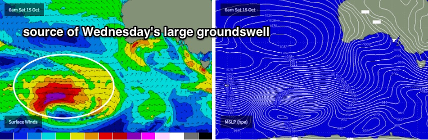
Therefore, I’m expecting most of the open Surf Coast breaks to see solid sets in the 5-6ft range on Wednesday, however the region’s swell magnets (such as the reefs surrounding Bells Beach) should see larger waves, possibly bombing as high as 6-8ft at times.
East of Melbourne, exposed beaches and reefs should be closer to 8-10ft, though these conditions will be great for Western Port (which will be a third of the size).
Wednesday’s peak in swell will ease rapidly into Thursday with pre-frontal northerly winds strengthening about the coast. Strong SW winds trailing these next fronts (earlier in their cycle, around Monday SW of WA) will renew moderate swell for the region around Friday, possibly back up into the 3-5ft range across the Surf Coast to finish the week, holding into next weekend too. Current indications are for moderate westerly winds across the region, which should be steered around to the W/NW west of Torquay thanks to local topographical effects.
So all in all, don’t worry about this weekend too much as we’ve got an exciting ahead for the Victorian coast starting Wednesday.
Comments
Not looking to shabby on the MP this morning!
spring hasn't been too shabby so far..
Good news thanks ben
Some nice small lines at 13th and Portsea this AM.
How's this inside Portsea bowl captured randomly by the surfcam!
Gary loves the irony of a straight 3ft swell with offshore winds being headlined 'forget the weekend', when our brethren up in QLD would offer a family member to the great god Gary for the chance to drop in on all their mates on waves like this with the recent flat spell.
Gary is also happy that Craig's forecast encouraged anyone within 100km of Melbourne to sleep in, there were some very fun waves around this morning at a spot I like to call 'Gary's'
thanks for the extra background information regarding the causes for the systems, really interesting stuff .. love local effects, thanks for not putting them in the automated forecast. would be very keen to see some meteorological explanations when they're applicable. if it's better than this weekend then yew!! love how many guys are out at thirteen compared to portsea Ben.. classic ! banks to yourself is good fun .. thanks Craig, have a good weekend hope you get some waves !
the winds were pretty weird yesterday, variable but with strength and it rotated 360deg. could someone provide an explanation for the occurence ? cracker day, epic in the morning before it blew away and straightened. still, protection is always useful. also, who is gary.. ?
all of your wildest dreams, personified.
xoxo
sounds like a lonely existence, my dreams are pretty dull
Only gary can tell you that, I can't find the words..........
Yeah well it's back to really cold in Margaret River today so I hope we are generating a lovely swell for you guys.
Send it on wbat