Fun swells from Friday, with a stronger S/SW swell for later Monday/Tuesday

Victoria Forecast by Craig Brokensha (issued Wednesday 24th August)
Best Days: Surf Coast Friday and Saturday, both coasts Sunday through Tuesday (beaches Surf Coast)
Recap
Smaller surf yesterday to 2-3ft on the Surf Coast and 3-4ft on the Mornington Peninsula with decent conditions under variable winds most of the day, while similar conditions are being seen today with less consistent surf.
This week and weekend (Aug 25 - 28)
Tomorrow was always looking like a lay day but now it is even more so, with an early W/NW'ly on the Surf Coast now more likely to be from the W/SW, tending S/SW through the day. There isn't expected to be much swell left at all either with fading 1-2ft waves on the Surf Coast and 2-3ft sets on the Mornington Peninsula.
Friday's SW groundswell is still on track, with an intense polar low firing up east of Heard Island generating a fetch of severe-gale pre-frontal W/NW winds, followed by post-frontal W/SW tending W/NW storm-force winds.
The swell will be inconsistent but should come in at a good 3ft on the sets across the Surf Coast with 4-6ft sets on the Mornington Peninsula.
Conditions will be better with a W/NW-NW offshore across the Surf Coast through the morning, possibly tending W/SW mid-afternoon.
Small surf is due into Saturday morning to 2-3ft and 4-5ft respectively as winds hold from the NW most of the day.
Into the afternoon and more so Sunday some new W/SW and SW groundswell is due, from from a strengthening polar front moving in from south of WA, closer towards Tassie.
A pre-frontal fetch of strong to gale-force W/NW winds will be followed by a weaker post-frontal fetch of SW winds, generating a mix of W/SW and SW swell.
Both coasts should steady in size Saturday afternoon, with Sunday seeing surf more to 3ft west of Melbourne, and 4-6ft on the Mornington Peninsula through the morning, smaller into the afternoon.
Conditions are looking great as well with local offshore breezes expected all day (N/NW Surf Coast and N-N/NE Mornington Peninsula.
Next week onwards (Aug 29 onwards)
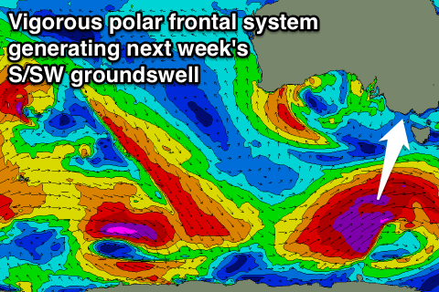 A drop in size is due Monday morning but later in the day and more so Tuesday, a strong pulse of S/SW groundswell is expected.
This will be generated by a vigorous polar frontal system firing up in our southern swell window over the weekend,generating a fetch of strengthening severe-gale to storm-force W/SW tending SW winds.
The swell is due to be biggest Tuesday morning, but should be seen late Monday, reaching 3-5ft by dark and easing from 4-5ft+ on the Surf Coast. The Mornington Peninsula should see better 6-8ft sets Tuesday morning.
Winds are looking best for locations east of Melbourne with a NE breeze (possibly N/NE Surf Coast), but we'll confirm this Friday.
Comments
In relation to that question about refraction and tide in last notes.
Im pretty sure you actually wrote a article on the 'unique' direction readings at Pt. Nepean buoy. But for direction i just look at the graph and more or less just take a average for actually direction? In saying that, there really doesnt seem to be much variation (180-210)
As for refraction, atleast for the Mornington Peninsula, from what i could understand looking at what maps i could find for bathymetry, that after the swell crosses the Otway Basin, from there in it rather flat at around 30m/100ft in depth. So any swell that is over 6 sec ( 6 x 6 = 36. 36 x 2.56 = 92ft) would start feeling the ocean floor therefore not refracting anywhere due to flat bathymetry of Bass Strait?
Not sure which source you're looking at but Bass Strait is an average of 75-80m where swell passes through.
Also equation to find depth felt is close to what you have. Wavelength = 1.56*period^2. Swell feels at half this.
So a 10s+ swell will start feeling the bottom, refracting more as it feels the shallower waters closer to shore.
10*10*1.56 / 2 = 78m
Cheers. So then say a 12 swell 12*12*1.56/2 = 112 would just sail in the angle its the shelf at. Does thay shelf even play a part haha?
Nah you've got it the wrong way.
A swell with lesser period will keep tracking on in its direction until it starts feeling shallower water. IE a 6s W swell will keep going west past the Surf Coast.
A 12s swell will bend in and follow the contours of Bass Strait. The higher the period the more it will then wrap further into protected spots.
Sorry, its coming out the wrong way. If the bathymetry is basically flat. When a swell with decent period comes through, whats to do the refracting if theres nothing to steer it? Is there any sites for bathymetry? All i could find really was https://www.environment.gov.au/system/files/resources/dc614f8f-b053-4388...
Ah yes, true the swell will be steered once it encounters that bathymetry to run at perfect right angles to it and then not change it it remains flat and feature less.
Ie if it was setup at a similar angle to Bass Strait (south-west to north-east) then a west swell will be steered more south-west, and a south swell, also more south-west.
Excellent! Thats what i was trying to figure out. Surely that would have to be the reason for the lack of variation in our swells i guess? Cheers!
The formula is simple: take the number of seconds between swells, square it, and then multiply by 2.56. The result will equal the depth the waves begin to feel the ocean floor. A 20-second swell will begin to feel the ocean floor at 1,024 feet of water (20 x 20 = 400. And then 400 x 2.56 = 1,024 feet deep
From Surfline. Is there formula different as accounting for feet instead of meters?
I could only find very basic bathymetry maps but i assume theres a bit more too it espically between Cape Otway to Pt. Lonsdale.
Yeah it gets much deeper drawing a line between Portsea and the entrance to Bass Strait.
Interesting stuff fellas cheers
Attenuation due to bottom friction is a big factor . Same as the coast im on . Try navionics free app nick b
Hmmm. Interesting thread. Craig - which chick do you forecast that The Bachelor will end up with?
Rumour has it that Gary-G is on the short list for the next series of The Bachelor.
Hako, if you can keep a secret we've been in negotiations for some time.
The sticking point for Gary is the small playing field relative to real life - in the current version of the show there's only 20 or so ladies looking for a little G time, which for Gary is more like a 'Survivor' situation.
Hey Craig/anyone else, this isn't really related to this at all but just a oceanography question for anyone who knows off the top of their heads .. Why are western boundary currents stronger than eastern boundary currents ? Doing a bit of research and it seems overly complicated however I think it need only be in reference to windstress, vorticity and flow ? Thought it'd be worth a try asking here .. also does it effect the longlivety of pressure systems and how long they stay on the E coast relative to W or S aus ?
PS very interesting stuff above nick and craig ... never really thought about that !! Only ever really considered the tracking of the pressure system not the deflection of the swell... is that why the building swell usually is lumpy and straightens up after it peaks ? Or is that due to the general shape of the rossby wave/lwt and the path of the low?
Yes, interesting discussion re refraction. I can;t help but wonder, though - is there any way a conversation like this can occur more discreetly, Nick? The polite side of me would say that the following is dripping with irony but.....the impact of period on refraction and its implications for swell penetration is one of the few remaining important pieces of info which forecasters and websites are yet to trumpet to the masses. It allows a relatively small group of dedicated and/or curious ocean-lovers to snavel the odd (increasingly) rare uncrowded session at certain spots. I'm not against people understanding this and enjoy new info myself, but I ask is it possible to have such a discussion discreetly, and without tuning a much larger audience into it? Even in another SNet forum focussed on technical issues which has an audience of the converted, rather than the swell notes which many others read?
The fed up side of me would say it might be your Eureka moment, but it does;t need to be everyone else's so for christ's sake think about it before you do it and pull your head in.
your an idiot