Easing surf, good new swell Sunday and then fun run next week

Victoria Forecast by Craig Brokensha (issued Wednesday 8th June)
Best Days: Thursday Surf Coast, Sunday both coasts, Monday onwards Surf Coast
Recap
Very small clean waves across the Surf Coast yesterday morning, bumpy and average to the east, while today a good new inconsistent W/SW groundswell has filled in. Clean inconsistent 3-4ft sets are breaking across the Surf Coast with larger 6ft+ surf on the Mornington Peninsula.
Conditions will remain clean all day on the Surf Coast and should improve to the east as winds swing more N'th.
This week and weekend (Jun 9 - 12)
Today's inconsistent W/SW groundswell is due to peak through the day, easing back slowly from the 3ft range on the Surf Coast tomorrow and 5-6ft on the Mornington Peninsula.
Conditions will be best west of Melbourne with a fresh NW tending W/NW breeze ahead of a mid-afternoon W/SW change.
The surf will continued to ease Friday under fresh W/NW tending NW winds.
The new swell due later Friday and more so Saturday from a strengthening cold front moving in from the west over the coming days has been downgraded a little, but the secondary intensification is still on track.
As a result small mid-period SW swell is due Saturday morning with possibly 1-2ft sets on the Surf Coast and 3-4ft waves on the Mornington Peninsula under W'ly tending fresh SW winds.
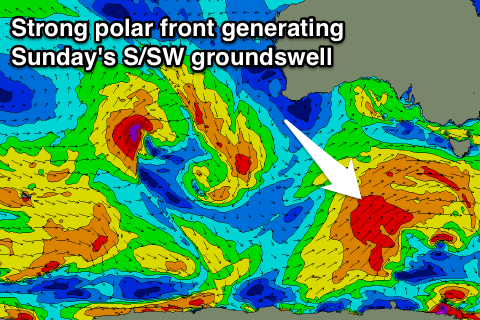 The stronger S/SW groundswell will be generated by a fetch of SW gales projecting north-east through our southern swell window during Friday and Saturday. The swell should kick through the afternoon and peak Sunday morning to a good 3-4ft+ on the Surf Coast (5ft sets swell magnets) and 6ft to occasionally 8ft on the Mornington Peninsula.
Winds will ease rapidly Sunday as a high quickly moves in from the west, creating glassy but likely still wobbly surf under a variable breeze.
Next week onwards (Jun 13 onwards)
We've got a great week of waves due across the Surf Coast from Monday as a series of strong polar fronts fire up one after the other through our south-western swell window. The fronts won't be overly strong or project too far north but with the constant activity, moderate sized of SW groundswell are due.
The first Monday should see good 3ft+ sets, more 3-4ft into the afternoon on the Surf Coast, with a larger and stronger pulse Tuesday afternoon and Wednesday to 3-5ft.
Winds look to remain favourable and from the NW – W/NW creating great conditions on the Surf Coast.