Fun surf in Torquay on Friday; generally poor weekend ahead

Victoria Surf Forecast by Ben Matson (issued Wednesday 25th May)
Best Days: Friday: easing combo of (very inconsistent) swells with good winds for the Surf Coast. Saturday AM: brief window of favourable winds at dawn.
Recap: Moderate W/SW swells through Tuesday and Wednesday with 2-3ft sets in Torquay and 4-5ft waves east of Melbourne. Winds were W/NW on Tuesday but veered more NW thru’ N’ly today as the swell started to lose more size and consistency.
This week (May 26th - 27th)
Looks like there’s been an ever-so-slight delay in the approaching swells for Thursday. But largely they’re still on track as per Monday’s estimates.
The first swell is due to push through Victorian waters overnight tonight, and although W’ly at the coast, will actually have originated from NW gales that developed SW of West Oz on Monday.
The second swell - more W/SW in direction - is expected to reach the Victorian coast mid-morning on Thursday, and will build all afternoon towards a peak overnight, or possibly even early Friday morning.
As such, the timing (and prospects) for good waves will depend heavily around the local winds. And I’m now a little hazy on Thursday’s surf prospects across all coasts.
A weak front is expected to clip the region in the morning, reaching the Surf Coast around 8-9am and the Mornington Peninsula around 10am. So you’ll have to be super quick at dawn to capitalise on the cleanest conditions - but surf size will probably be small at this time - maybe 1-2ft and very inconsistent.
Wave heights are expected to increase throughout the day and will probably nudge 3ft or maybe 3-4ft late in the day but the onshore will likely be quite well established by this time - not with any major strength, but certainly enough to bump up surface conditions.
East of Melbourne we can expect a slightly bigger, more wind affected version of the Surf Coast.
Friday looks like a much better option for surfers. The front will have cleared to the east by this time and most coasts should be under a light W/NW breeze (maybe moderate to fresh east of Melbourne to begin with) but we should see some fun, albeit very inconsistent waves in Torquay around the 3-4ft mark.
Because of the strong westerly component in the swell direction, it’s likely that we’ll see very long breaks between the bigger waves but on the balance it’s certainly looking to be the pick of the forecast period. But let me reiterate the consistency (or lack thereof) - I think Friday’s set waves are going to be much less frequent than normal Victorian surf conditions, which by default are usually pretty inconsistent anyway. So bear this in mind when choosing your surf spot.
Open beaches east of Melbourne are probably going to be too big at first on Friday (5-6ft+) but conversely, it’s likely to be too small for anything meaningful at Western Port. However there’ll be a bunch of mid-way locations that should work well under this scenario.
This weekend (Saturday 28th - Sunday 29th)
The weekend forecast has become a little trickier thanks to the models now developing a series of small low pressure systems within a broad trough over the eastern states.
This is expected to freshen S/SW winds across the region throughout Saturday, strengthening considerably into Sunday as a new low forms east of Tasmania, driving southerly gales across mosts coasts.
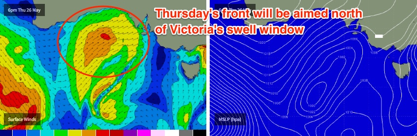
Couple in this deteriorating wind forecast with no major new swell events - a front travelling through the Bight on Thursday and Friday will be aimed north of Victoria’s swell window - and the best solution for the weekend could be to aim for a dawn patrol on Saturday as that’s the only chance for a window of favourable conditions.
Saturday’s onshore could generate some local windswell for Sunday - that could be enough to get the protected points west of Torquay working with small surf - but it’s not worth rescheduling your diary around at this stage.
For now I’m expecting wave heights somewhere in the 2-3ft range in Torquay both days, up to 4-5ft east of Melbourne but very wind affected.
Let’s see how Friday’s model runs pan out.
Next week (Monday 30th onwards)
We’ve still got an active Southern Ocean period ahead however there are two distinct features: (1) all activity in our near or mid-range swell window looks to be quite unconsolidated (so, not great for producing quality surf), and (2) some intense storm activity - generating excellent groundswell events - will develop much further west, in our far swell window (so, the large travel distance will erode a significant percentage of their size).
Short version is there’s nothing to pin our hats on right now, but we will see surrfable waves most days. If I had to ball park the first half and the second half of the week, right now I’d anticipate slow, lacklustre waves from Mon thru’ Wed, with the second half of next week and the following weekend looking much better for quality surf prospects. More on this in Friday’s update.
Comments
Good too see dan report the correct size this arvo. Well done pal!
Next week the could be some E's instead of W's??
Decent J-curve at the Sorell buoy with peak swell periods hitting 18 seconds a few hours ago. Should see a jump in size at the coast this afternoon.