Plenty of swell for the period, only clean Friday morning

Victoria Forecast by Craig Brokensha (issued Wednesday 9th March)
Best Days: Friday morning both coasts
Recap
A good building SW groundswell yesterday with average winds through the morning, improving through the afternoon while tending more E'ly and then variable. Good 3-4ft sets were seen across exposed breaks, with 5-6ft sets on the Mornington Peninsula.
Today the swell has held a similar size this morning with varying winds depending on where you are. The Mornington Peninsula was a clean 5-6ft, with bumpy waves across 13th Beach and offshores again around Torquay. Onshore winds have since moved in across all locations, (around the forecast 8am time on Monday) creating poor conditions.
This week and weekend (Mar 10 - 13)
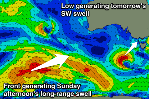
Yesterday's and this morning's SW groundswell is due to ease off through this afternoon and Cape Sorell is showing this dip already. A low point in activity is due early tomorrow ahead of a new short-range SW swell filling in through the day.
This is being generated by a tight and intense mid-latitude low to our south-west, with the fetch of gales now due to be aimed more through our south-western swell window rather than southern.
 The Surf Coast should build to 3ft+ through the day, with 5-6ft sets on the Mornington Peninsula, peaking through the afternoon before easing back from 2-3ft and 5ft respectively Friday morning.
Conditions are still looking average tomorrow with a light to moderate and freshening SE breeze, while Friday is the pick with variable breezes through the morning ahead of afternoon sea breezes.
Saturday will see an onshore SE'ly breeze kick in again with small easing surf, making it a good lay day.
Into Sunday our new long-range and inconsistent SW groundswell is still on track, with the strong polar low linked to it currently south-west of WA. This low generated an initial fetch of severe-gale winds in our far far swell window, easing back to the gale-force range while tracking east, with it today due to project a fetch of weakening W/SW gales up towards the Bight.
The swell should build slowly through Sunday from a small and inconsistent 2ft+ early on the Surf Coast and 3-4ft+ on the Mornington Peninsula, reaching 3ft+ and 6ft respectively into the afternoon/evening.
Winds are still an issue, with E/SE breezes due across the Surf Coast and Mornington Peninsula early, possibly tending more E/NE through the morning ahead of afternoon sea breezes. Monday unfortunately doesn't look any better with a fresher onshore S'ly breeze and reinforcing SW swell from a broad pre-frontal fetch of W/NW gales under WA.
Next week onwards (Mar 14 onwards)
Besides the onshore winds and moderate amounts of swell for Monday, another moderate pulse of SW groundswell is due through Tuesday, produced on the back of the pre-frontal fetch, with a better aligned fetch of W/SW gales moving under the country on Sunday.
The Surf Coast should hold the 3ft+ range with 5-6ft sets on the Mornington Peninsula, but a deepening inland surface trough will bring strong E/SE winds to both coasts along with building levels of SE windswell.
The trough and fetch of strong E/SE winds are due to persist through Wednesday before breaking down hopefully Thursday, with poor conditions continuing later next week. More on this Friday.
Comments
.