Good swell but onshore tomorrow, cleaner Wednesday morning

Victoria Forecast by Craig Brokensha (issued Monday 15th February)
Best Days: Tuesday morning keen surfers protected spots Surf Coast, Wednesday morning Surf Coast, possibly Friday morning Surf Coast, Sunday east of Melbourne
Recap
A limited but good window of clean conditions across both coasts Saturday morning with easing 2-3ft waves on the Surf Coast and in the 4ft range on the Mornington Peninsula.
Sunday morning started smaller with an early NW breeze, with a new swell and onshore wind developing through the day, offering fun waves for keen surfers across the protected reefs west of Melbourne.
This morning a secondary better pulse of SW groundswell along with offshore winds was offering great 3-4ft sets on the Surf Coast, with bumpy and average 6ft+ sets across the open beaches on the Mornington Peninsula.
This week (Feb 16 - 19)
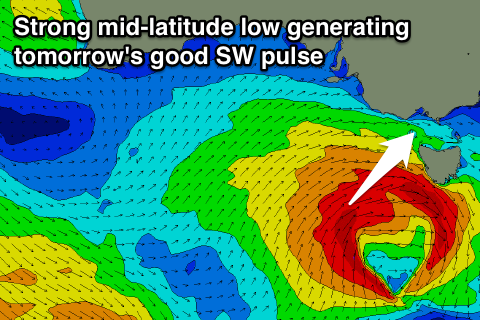 We've had an upgrade in the size of a reinforcing SW swell due across the state tomorrow, with a relatively weak cold front moving in from the west now forming into a strong mid-latitude low under the effects of a strong node (peak) of the Long Wave Trough.
We're now seeing a fetch of gale to near severe-gale W/SW winds being generated on an already active sea state immediately to our south-west, producing a moderate to large sized SW groundswell event for tomorrow.
The swell should peak through tomorrow morning/midday across both coasts with solid 4-5ft sets on the Surf Coast and 8ft+ waves on the Mornington Peninsula, but with fresh to strong SW winds.
There's a very slim chance that the Torquay region may see winds veer slightly more westerly to the W/SW, but keep your expectations low.
Wednesday will be a better bet for a morning W/NW'ly across the Surf Coast with easing 3-4ft sets and onshore average 6ft+ waves on the Mornington Peninsula.
Background frontal activity will keep both coasts active into Thursday morning, likely not dropping below 3ft and 5ft+ respectively but winds look a little less ideal and from the S/SW.
Into Friday a good new pulse of SW groundswell is due from a vast but less than ideally aligned pre-frontal fetch of NW gales south-west of WA.
While looking unfavourably aligned, we should still see some radial spread off this fetch with a new SW groundswell pulse for Friday morning to 3ft+ on the Surf Coast and 5-6ft on the Mornington Peninsula.
Winds are looking to persist from the S/SW but without much strength, and there's a slim chance for early W'ly winds on the Surf Coast, but we'll review this Wednesday.
This weekend onwards (Feb 20 onwards)
The weekend will start average with a slight drop in swell and moderate to fresh S/SE winds, while Sunday looks better with an easing SW swell and E/NE offshores for the Mornington Peninsula. Size wise we're probably looking at easing surf in the 4-5ft range but check back here Wednesday for more on this.
Comments
No mention in this forecast of the storm clouds brewing over Geelong thanks to the exposed actions of a well known Melbourne Garry over the weekend?
A few fun waves early on Sat morning, Craig. Although I barely got time to film a go pro of myself drinking a beer in the barrel after stepping off a Jetski before that change came through.
Hey Craig thanks for the forecasts. In regards to the Cape Sorell wave bouy, how do you estimate the time it takes for the swell to hit Vic (Torquay, Mornington and PI) and the size of the swell going off the bouy reading?
Thanks
observe the ocean and look at the cape sorell wave data. Simple.
I never knew bass straight had a "western entrance".
Can't see the ocean from Melbourne unfortunately
Yeah I know the adds on swellnets surfcams come on every time there is a set! or the camera pans off the banks every time a set is approaching. I'v never been so frustrated looking at the sea before. It helps kill time at work.
Do you see the ocean when you surf??
Guess what? There's an eastern entrance to.
yeah I know the eastern entrance pretty well because i have sailed it from all approaches in all weather but i have only used the "western entrance" once and that was to EXIT bass straight!
Great question Schwaino.
So firstly look at this diagram.
Any swell hitting Cape Sorell Wave buoy from a generaly south-west direction should also hit a similar point at the entrance to western Bass Strait at the same time.
I've calculated roughly the distance from this point to the Mornington Peninsula as 180km.
You can calculate the swell speed relative to its period with this equation. Speed = 2.81*period.
So a 16s swell travels at approx 44.96km/h
If the period is less it is slower, and if period is higher then it is faster.
Taking the 180km distance into account it should therefore take about 4 hours for a swell showing on the Cape Sorell buoy with Maximum Periods of 16s.
Looking at the line I've drawn also, you'll probably notice that if the swell is more west at 16s it will arrive quicker than if it were more south at 16s as there's less/more distance to travel.
Why do you spoon-feed info like this to people who aren't dedicated enough to put in the time to work it out for themselves? Some people have put in a lot of effort to work out things like this for themselves and you just give it away for free to any idiot that asks? And for what? A few kooks boosting your ego? Or a few more hits for your website?
That's the purpose of this site, to provide the tools for people to make a decision on where and when they're going to surf. We’re not disclosing locations, so users still have to join the dots themselves in order to score good waves.
Sorry Craig my brother told me to right that. I like to read stuff Luke that cause im only 15 and won't to learn this things but my brother want teach me. His real angry and says your a sellout.
How come craig never answers my questions ! So the regular readers say why has craig just done this gold plated diagram for a new name ? You must be lucky ? Craig delivers the goods
Haha I try to answer your questions all the time, although they're trickier than this easy one which I quickly whipped up the image to.
Re buoy question , how much attenuation due to bottom friction does esperance buoy lose ? Why is the buoy inside shelter waters ?
I would say that it loses more from having little in the way of openness to more Western aspect .
But yeah there would be some attenuation . I think they have them there for industry not surfing . And that would give them some size
records on SE swells .
The buoy doesn't receive s-e swell so much because it is shadowed on the se quadrant
It recieves sw predominantly in comparison to alb which is open to the se
Cool . I would suspect that it would be similar to Pt Nepean and CDC difference . ( that is Albany compared to Esp. )
Excepting no tide influence . I would think that the less west aspect would over shadow the bathmetry antenuating influence though . Combined would be similar . And yeah 40% would be similar to here . Although bathymetry alone changes with swell period . And size more so with tide . I still think that the majority of swells especially over there run from a more west aspect than here . ( on average ) like across the year it would be close to 235 here and more so nearer 240 there . Obviously different seasons would vary though and even early compared to late seasons may vary .
Southey theres major loss of size actually about 40%
Hmm, now this is one of those tricky questions.
Without hi-res modelling I can't say sorry. That can only be found by running the wave watch model with hi-res bathymetry around the region.
As you said it's sheltered by SE swells but also probably sheltered from certain W/SW-S/SW swells, not the best buoy to be monitoring incoming swells at all. Probably for industry in and around the islands rather than ships out to sea.
Wow! Perfect Craig im all over it like a rash. Thanks
*All over it like a Melbournian on the Vline to Torquay
a sth swell you will have more time possibly how long ?
It takes years to learn that stuff, craig thats the biggest question that no one can answer!
Bass straight currents will change the speed drastically & other unspecified mysteries . Good work craig & quite a trade secret there crew up for grabs
You guys are REALLY lost .........
There's only ever one swell direction for VIC and that's SW . . Maybe throw in a ESE wind swell once every few months . ;-)
Stop complicating things . Most swells arrive 4-6 hours after Sorrel to the heads .
Small variances mean fuck all :ie who cares if it's 1 hr early or late . Schwaino just remember to not bother showing up at Pt Leo any other time than 2-3 before high tide .
"You guys are REALLY lost .........
There's only ever one swell direction for VIC and that's SW .Stop complicating things"
Easy then isn't Southey..
One swell direction, in a bath with him and tree.
Now that there's a buoy at bremer, have seen se swells or anything near about SE + - the swell is recieved unhindered. There been regular se swell events, also any big swells from the south it's a good buoy.
At the same time the Esperance buoy doesn't seem to get anything from SE .
Too many islands and reefs shadow it. Bremer buoy is great addition imo and since Albany has been broke nearly a year unfortunately, we are missing that one...
Agh, I haven't been keeping an eye on Bremer. Nice and exposed.
Esperance is in near town, blocked by Cape Le Grand to the SE and all those islands from proper SW swells.