Fun weekend ahead with a good swell and better winds

Victoria Forecast by Craig Brokensha (issued Wednesday 6th January)
Best Days: Keen surfers early Friday Torquay region, Saturday morning, Sunday morning, Monday morning small clean waves
Recap
Smaller amounts of easing SE windswell across both coasts yesterday from 2-3ft to the west of Melbourne and a similar size to the east with poor and fresh E/SE winds.
Today with the winds through Bass Strait weakening slowly, the SE windswell has dropped back to a small 2ft, with an inconsistent 3ft of groundswell on the Mornington Peninsula as winds persist from the SE.
This week and weekend (Jan 7 – Jan 10)
There's been little change to the end of the week's outlook with onshore S/SW winds and leftover amounts of swell due tomorrow morning ahead of a late kick in new SW groundswell. This swell should build to 2ft+ on the Surf Coast and 4-5ft on the Mornington Peninsula but with no let up in the onshore breeze.
Friday will see the swell ease as moderate to fresh S/SW winds continue. There's a slim chance for an early W'ly around Torquay, but it's not worth the drive from Melbourne.
 Our better SW groundswell due over the weekend is still on track, with a slight upgrade in the size.
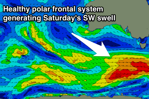
A vigorous polar front will generate a pre-frontal fetch of W/NW gales followed by post-frontal W/SW gales, producing a good SW groundswell for Saturday morning.
The Surf Coast should see good 3ft+ waves across most spots through the morning with 4ft sets at swell magnets, easing through the day, with 6ft+ waves on the Mornington Peninsula and 8ft sets at swell magnets again.
Winds will be much lighter from the SW Saturday morning, and likely W/NW early on the Surf Coast creating good conditions.
As the swell eases Sunday more variable breezes from the E are due, favouring the beaches across both coasts with easing 2-3ft sets to the west and 4-5ft+ waves on the Mornington Peninsula.
Next week onwards (Jan 11 onwards)
Into Monday the models are showing a good kick in new SW groundswell. This is an error though, as the groundswell showing on the charts is from our far swell window in the southern Indian Ocean.
This swell will provide some reinforcing swell to an inconsistent 2ft or so on the Surf Coast and 3-4ft+ on the Mornington Peninsula with morning local offshores ahead of a shallow S/SW change.
Onshore winds are likely to linger into Tuesday as the swell eases with nothing significant for the rest of the week at this stage. More on this Friday though.
Comments
Those morning offshores were originally due on sunday for MP, but have moved to monday. So now i'm leaning to monday for cleanliness over sundays size. Seeing as i'm travelling from near the city do you reckon that's the pick?
Sunday should still be good though, winds looking light NE, and similar on Monday morning, so aim for the better sized day.
Will do. Thanks bud
After a week of strong onshores and a NE that may or may not happen overnight I would not bother, it will be average and sloppy regardless of winds
Looking at cruising down with a few mates from the city well 12 of us three cars should really get a bus lol. What coast would be best Craig?
west coast. definately west coast.
west coast. definately west coast.