Cleaner conditions Thursday and early Friday with building swells

Victoria Forecast by Craig Brokensha (issued Wednesday 16th December)
Best Days: East of Melbourne Thursday morning, early Friday, Saturday morning, Sunday morning
Recap
Poor conditions yesterday with a tiny swell on the Surf Coast and 3ft sets on the Mornington Peninsula with no real quality.
Today is even worse with tiny amounts of swell with a persistent onshore wind.
This week and weekend (Dec 15 - 20)
Tomorrow will see good conditions across the Mornington Peninsula and Surf Coast beaches with a N/NE offshore but the swell will remain minimal, with only a very slight increase in W/SW groundswell due through the late morning.
Early only small infrequent 2ft sets are due, with a kick to 3ft sets due before midday. Conditions should remain clean until about midday before afternoon sea breezes start to kick in.
A slightly stronger increase in long-range W/SW groundswell is due through Friday, generated the last few days by a slow moving polar low south-west of WA.
The swell should build to an infrequent 3-5ft on the Mornington Peninsula through the late morning, with 2ft sets on the Surf Coast, easing Saturday from 3-4ft and 2ft respectively during the morning.
Variable winds are due Friday morning, but you'll have to get in early as an onshore S/SE'ly is expected to develop by mid-morning.
NE winds will favour the Mornington Peninsula Saturday morning as the swell eases, while Sunday morning will be even smaller with stronger and straighter N'ly winds ahead of an afternoon W'ly change.
Next week onwards (Dec 21 onwards)
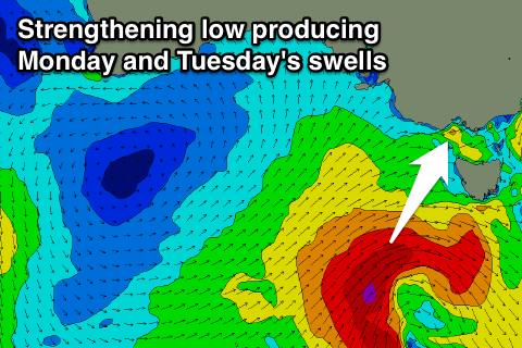 As talked about on Monday, an intense mid-latitude low is forecast to develop this weekend, but initially it will be south-southwest of WA and better aligned for swell production across the Southern Australian coast.
The low is expected to weaken a touch while moving east through the Bight before re-strengthening to our south-west Sunday, aiming a fetch of gale to severe-gale SW winds through our south-west and then southern swell window.
The low will track slowly in a less than ideal south-east direction, but we should still see a fun pulse of SW veering S/SW groundswell building Monday and then easing Tuesday.
The Surf Coast should build to 3ft on the sets Monday afternoon with 5-6ft sets on the Mornington Peninsula but along with poor S/SW tending S/SE winds.
The swell should then ease from a similar size Tuesday morning but with what looks to be E/SE winds. Cleaner conditions are likely Wednesday morning east of Melbourne as the swell eases quickly.
Longer term some new W/SW groundswell is a possibility for later in the week/the following weekend, but we'll have another look at this Friday.