Fun weekend, best Sunday and then good at exposed spots early Monday

Victoria Forecast by Craig Brokensha (issued Friday 11th December)
Best Days: Torquay early Saturday, both coasts Sunday, and early Monday
Recap
Great fun waves across both coasts yesterday with a good kick in W/SW groundswell to 3-4ft across exposed breaks on the Surf Coast and 6-8ft on the Mornington Peninsula, favouring Flinders.
Winds were locally offshore across both regions before afternoon sea breezes kicked in.
The swell is easing back this morning from a clean 3ft on the Surf Coast and choppy 4-5ft on the Mornington Peninsula. Winds are now starting to swing onshore, so make the most of the current conditions.
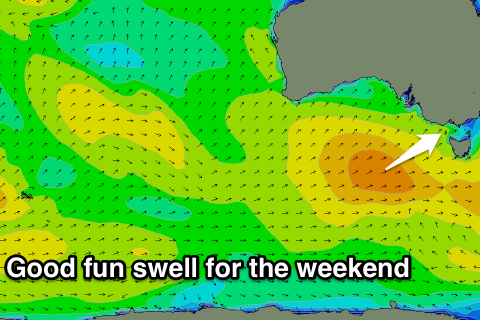 This weekend and next week (Dec 12 - 18)
Another fun pulse of W/SW groundswell is due later today, peaking tomorrow morning across the coast, similar in size to yesterday's but with less strength due to it being a mid-period number.
The front linked to the swell is moving through today bringing our onshore change, with a secondary push up and into us overnight, helping keep the size up most of the day tomorrow.
Swell magnets should see 3-4ft sets on the Surf Coast tomorrow morning, with 6ft to possibly 8ft waves on the Mornington Peninsula. Winds will be the main issue with a fresh SW onshore due across most locations, although Torquay should see an early W'ly favouring the protected reefs.
Sunday morning will be much cleaner across the whole state as winds swing locally offshore from the N/NW on the Surf Coast and N/NE on the Mornington Peninsula with an easing swell from 3ft and 5-6ft respectively.
A small mid-period W/SW swell is due into Monday to 2ft on the Surf Coast and 3-4ft on the Mornington Peninsula, with variable winds through the morning and clean conditions, increasing from the SE from mid-late morning.
Tuesday will see the swell ease with light to moderate onshore SE winds from the get go, tinier Wednesday as S/SE winds persist.
Into the end of the week we may see a small to moderate sized kick in SW groundswell from a slow moving polar low but this also looks to arrive with onshore winds. If we're lucky winds should swing N/NE as the swell eases into next weekend, but we'll review this Monday. Have a great weekend!
Comments
Lorne in all its afternoon glory (all one foot of it, anyway).