Surf Coast set to pump next week

Victoria Forecast by Craig Brokensha (issued Friday 20th November)
Best Days: Sunday afternoon, Monday morning, Tuesday, Wednesday, Friday morning
Recap
Small to tiny waves continued yesterday with the Portsea region the only real option for a decent wave with small 2ft sets and OK winds. Today similar sized surf and an onshore made the beach far from appealing.
This week and next (Nov 21 - 27)
Tomorrow's acute W'ly swell is still on track and I believe the wave models are over-forecasting the size for the Surf Coast. Due to the unfavourable fetch from the low that generated it under WA, we're only likely to see 2ft+ sets at swell magnets on the Surf Coast with maybe 4-5ft+ waves on the Mornington Peninsula.
Conditions will be poor anyway with a fresh to strong SW change moving through before dawn, with only a slim chance for an early W'ly wind, but protected spots handling this will be small to tiny.
Sunday morning should be clean with a morning W/NW'ly, but the swell easing from a small 2ft on the Surf Coast and 3-5ft on the Mornington Peninsula.
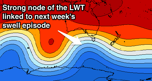 Our extended run of strong groundswells from Sunday afternoon through next week is coming together nicely, with two successive and different phases of the Long Wave Trough due to influence our swell window.
The first is currently steering a vigorous polar frontal progression from the south-east Indian Ocean up towards Tasmania, generating multiple fetches of W/SW gales.
We should see a moderate to large SW groundswell result from this first incarnation, building very strongly Sunday afternoon and peaking late to 4-5ft on the Surf Coast and 6-8ft+ on the Mornington Peninsula. Winds will be onshore from the W/SW but workable across the Surf Coast for keen surfers.
A slight drop is due into Monday morning with a reinforcing SW groundswell filling in from a secondary weaker front moving through our swell window. This should keep the Surf Coast around 3-5ft, with 6-8ft sets on the Mornington Peninsula, dropping back into Tuesday morning.
Now the second phase of the Long Wave Trough will be more pronounced across Victoria, directing front after front straight up towards us from Sunday through most of next week, while slowly pushing east.
This will generated pulses of SW tending S/SW swell, the first large pulse building later Tuesday to 3-5ft on the Surf Coast and 6-8ft on the Mornington Peninsula, peaking Wednesday to 4-5ft and 6-8ft+ respectively.
The surf is likely to hold around this size for Thursday before easing slowly Friday out of a more S/SW direction.
Now, winds look great for the Surf Coast each morning with W/NW-NW offshores Monday through Wednesday, only swinging SW Monday afternoon. Thursday looks onshore from the SW, with early W/NW winds again Friday morning. We'll confirm this Monday. Have a great weekend!
Comments
Hi Craig
Don't mean to sound like a tool, but I think your best days are meant to say tues, wed west of melbourne. Not east?
Unless that's a cunning plan by you ?!
Cue evil laugh....
Ha, ah yes, thanks for that, was from an earlier update.
Ahhhhh. The goddess Shitoria keeps smiling on the peninsula.. Praise thee
Hi Craig,
Just got some questions about long wave troughs. Are long wave trough able to bring swell in the weeks too come after Monday Tuesday and Wednesday and if so do you see any swell from them in the long term forcast. Bit confused about what they are.
Cheers mate
How good is Woolamai going to be this week. Pumping. Gunnamatta is going to be heaving too.
Likely sorento
Sorrento, here's an article describing the LWT.. https://www.swellnet.com/news/swellnet-dispatch/2011/07/07/long-wave-trough-waves-create-waves
And also a link to the forecast: http://www.weatherzone.com.au/models/?lt=hemisphere&lc=sh
When a node of the LWT is positioned and stalls in a certain area, it will continue to steer and focus frontal activity into that region as long as it is there. Once it moves off or weakens, this activity will subside.
Craig what has changed re bens mentioned it ? Slightly more westerly track . Wind forecast has changed a bit for me
What's that sorry Cam?
Something ben said " changed slightly" I think ben did an article then linked it to this article & I posted comment here . Obviously too late now but I think it was about a slight change in forecast from the original cast . Weds wind cast was of interest at the time . but now its a west wind & I will have to imagine being over on the island . Seeing I still can't get over there and surf it . Originally it was nnw and that was of importance because of a certain potential break firing
Yep roger that.
Yes it looks like the LWT is stalling a little further west than forecasts last Friday, meaning a change in wind outlook.