Plenty of good swell, spoilt by onshore winds

Victoria Forecast by Craig Brokensha (issued Monday 9th November)
Best Days: Thursday morning beaches on Surf Coast
Recap
Winds were poor Saturday with no real early W'ly seen around Torquay making for onshore messy and junky waves across both coasts.
Sunday was the pick with improving and clean conditions under light local offshore winds and with fun amounts of swell easing from 2-3ft on the Surf Coast and 4-5ft on the Mornington Peninsula.
Today, conditions are again great across both coasts with light local offshore winds, and the strong new but very inconsistent SW groundswell is starting to fill in across the state. Early the Mornington Peninsula was in the 3-5ft range before kicking to a solid 6ft+ this morning. The Surf Coast was around 2-3ft at exposed breaks this morning, but some bigger sets are now starting to show, and we should see the swell pulsing strongly after lunch, with the Cape Sorell readings looking real healthy this morning.
The Surf Coast should reach an inconsistent 3-5ft, with 6-8ft sets on the Mornington Peninsula as winds tend variable ahead of a change probably around 3-4pm.
This week (Nov 10 - 13)
Make the most of today's waves, as we've got average conditions on the cards for both tomorrow and Wednesday. There'll be plenty of swell though, with strong and elongated polar frontal activity on the back of the 'bombing low' that generated today's swell, generating moderate sized SW swell for tomorrow and Wednesday.
Tomorrow morning will likely fall back to the 3-4ft range on the Surf Coast with 6ft+ sets on the Mornington Peninsula, with a late kick in new swell to 3-5ft and 6-8ft respectively. The swell should then drop from a similar size early Wednesday, down through the day and backing off further from 3ft and 6ft respectively Thursday morning.
Fresh S/SW tending S/SE winds tomorrow will create terrible conditions, with Wednesday seeing fresh S/SE tending SE breezes, strengthening from the E/SE into the afternoon. There is a small trough lingering in the region on Wednesday morning, with the slimmest chance of variable winds, but the ocean will be quite agitated and not too inviting.
As touched on Friday, Thursday will be the day to surf as winds swing around to the NE through the morning and variable on the Surf Coast. The only issue is the size east of Melbourne for the beaches, while to the west, the Surf Coast beaches will be the pick.
Friday unfortunately looks poor again with smaller amounts of swell and another S/SW change as a trough pushes in from the west.
This weekend onwards (Nov 14 onwards)
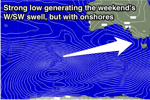
Into Friday afternoon and more so Saturday a long-range and inconsistent W/SW groundswell is due to fill in, generated by a very nice looking polar low firing up around the Heard Island region last night. This low will project a good fetch of W/SW gales towards the south-west of WA over the coming couple of days before weakening slowly and dipping east-southeast under the country through Wednesday evening.
A moderate sized W/SW groundswell should be generated, building later Friday and peaking Saturday to 3-4ft+ at exposed breaks on the Surf Coast and 6-8ft on the Mornington Peninsula.
Conditions are unfortunately looking poor Saturday with moderate to fresh S/SW breezes in the wake of Friday's change, with a possible early W'ly Sunday morning as the swell eases.
Comments
Looking tasty this arvo. How's the fella in the first image leaning into the bowl!