Complex period ahead for Victoria; mainly small surf in Torquay

Victorian Surf Forecast by Ben Matson (issued Monday 28th September)
Best Days: Tues: early NW winds and a small swell for Torquay. Fri: chance for a small, interesting W/SW tending SW swell with NW winds in Torquay. Easing Sat. Sun: Building W'ly swells, only small in Torquay but clean under a NW wind. Easing Mon. Next Wed thru' weekend: More W'ly tending W/SW then SW swells - quite an active period ahead.
Recap: Mainly small/mod swells over the weekend with E’ly winds Sat swinging NE Sunday, favouring the open beaches east of Melbourne. Early light N’ly winds across the coast this morning preceded a W/SW change that reached the Mornington Peninsula just after noon, and wave heights are still small across the region (though the Torquay surf is showing a smidge more energy than earlier, possibly signs of a building trend expected into Tuesday).
This week (Sep 29 - Oct 2)
The forecast for this week is still pretty complex even though there are no major weather systems expected to develop within our primary swell windows.
We’re currently awaiting the arrival of a small long range SW groundswell, generated by a series of polar lows east of Heard Island last week. No significant size is expected from this energy - it’ll probably bump up wave heights marginally into Tuesday from today - and set waves will be rather inconsistent.
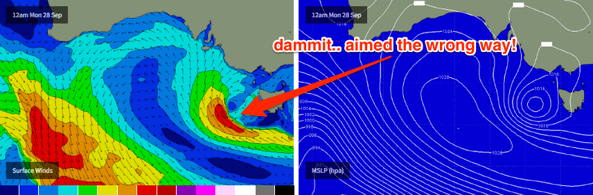
The synoptic chart presently has a low forming west of Tasmania (see chart below). Whilst this looks good on paper, in actual fact it’s somewhat of a mirage (for Victorian surf potential) as the strongest pressure gradient is along its south-western flank, aimed up into South Australia.
If you check out the animated WAMS (select “Zoom 2” for the best resolution) you’ll see that although the top of the low eventually pushes into western Bass Strait, there’s no major strength in the wind field by this time. And the south-west flank of the low is expected to remain under the influence of a strong ridge to the south, which will predominantly aim it away from our swell window.
So - I’m not expecting any major energy from this system. We should see early NW winds tending W/NW mid-morning, then W’ly ahead of a W/SW tendency from about lunchtime or early afternoon, then SW mid-late afternoon. As such conditions will get progressively worse as the day wears on - the morning should have the best conditions for Torquay (I can’t see there being anything of interest east of Melbourne on Tuesday, mainly due to the winds).
Set waves across the Surf Coast are expected to hold somewhere between an inconsistent 2ft and maybe 3ft if we’re lucky (I think the wave model is slightly overcooking the data); east of Melbourne expect wind affected 4-5ft surf.
Easing S’ly winds are expected on Wednesday, but they’ll only be light to moderate in strength and this should allow for a period of NW winds in Torquay early morning. However, surf size will be trending down by this time - inconsistent early 2ft+ sets with smaller waves expected throughout the day. Despite the lighter winds I’m doubtful that there’ll be any meaningful surf east of Melbourne either.
Thursday is showing some interesting activity on the swell period charts, with a defined swell front expected to push through on Wednesday evening. However, this appears to have been generated by a pre-frontal NW fetch in the Indian Ocean over the last day or so (which is surprisingly not that far off-axis from Victoria’s swell window) - but the large travel distance and modest fetch means that the associated swell size isn’t very big. As such I’m expecting small surf in Torquay on Thursday (1-2ft) with offshore winds. Wave heights will be bigger east of Melbourne as per usual but the westerly component in the wind direction will probably render most beaches bumpy.
Friday also looks equally interesting, with yet another swell front expected to push through the region, this time (again) originating from a strong NW flow down the eastern flank of the Long Wave Trough in the Southern Indian Ocean.
However, this system looks a little more promising for a couple of regions: (1) it’s expected to reach maturity a lot closer to our coast, and (2) model guidance has an embeded low forming and intensifying later Wednesday, immediately SW of Bass Strait - stalling briefly with a small SW fetch developing on its back flank, with wind speeds reaching 40-50kts. This is just on the periphery of our short range swell window.
Ordinarily it’s easy to dismiss these kinds of systems as they’re not following the time-honoured storm track from polar latitudes up into Victorian waters. However, I have seen surprisingly good surf develop from these patterns before and if the model guidance ramps up any of the points above we could be looking at some nice waves along the Surf Coast under a NW breeze. Let’s take a look at the data more closely on Wednesday to see what Friday may hold in store for us.
This weekend (Oct 3 - 4)
The period charts are awash with reds and purples for the weekend, which ordinarily suggests good (long period) swells - however we have to be careful this weekend as the direction will play a big part in how much size we see at various locales.
All of this energy is originating form the eastern flank of the Long Wave Trough in the Indian Ocean; in fact the predominant fetch is NW thru’ W/NW in direction, meaning the resulting swells through Victoria will have a lot of west in their direction. The storm track is riding unusually north in latitude at the moment (great time to book a last minute trip to Indo, if you can).
This means that we see a disproportionately large range in wave heights between more sheltered coasts (i.e. Torquay) compared to exposed coasts (i.e. Morn Pen, Phillip Island). However, the other characteristic about these patterns is that local winds are typically NW for extended periods - which doesn’t always favour exposed coasts (apart from brief periods of N’ly winds between troughs). But it's great for Torquay.
So, the upshot is that after Friday’s possible SW swell spike eases through Saturday, we can expect surf size to building overnight and into Sunday with the arrival of the new energy - but with longer than normal breaks between sets, and only small size in Torquay. At this stage I’ll aim for clean 2ft waves early Saturday (easing into the afternoon), rebuilding to a very inconsistent 2-3ft into Sunday.
However east of Melbourne is likely to be much, much bigger with sets well in excess of 6ft+ at times (at exposed beaches). I’ll have more details on this in Wednesday’s update.
Next week (Oct 5 onwards)
The last day of the Long Weekend looks like it’ll maintain Sunday’s size before easing throughout the day.
Beyond this, we have a strong series of W’ly tending W/SW then eventually SW swells as the Long Wave Trough finally moves slowly eastwards into our swell window. At this stage, the first (W’ly swell is due to arrive later Tuesday ahead of a peak on Wednesday, with the followup W/SW and SW swells padding out the back half of the week and the following weekend. More on this in Wednesday’d update.
Comments
Ben is there any chance of a sneaky barrel tommorow morning on the surf coast. I'm really keen for the baz. Basel Wasel barrel baz
Oh jeez.. after writing all that, you still need more info?
Sorry Ben but don't think you forecast wether it would barrel or not so I think you need to include thats next time.
Bloody long wait for the sets but there's a few around.
Shame about the freshening NW winds as it's getting bumpy across the Bellarine.
Hi barrell chaser
I'm flying in to brisbane from NZ tonight
Do you reckon if I hire a car and drive down to torkers we could chase barrell together?
I'm hiring a motorbike. You can sit on the bars holding the boards. I got a 14 ft SUP
It's epic for getting in the tube deeper than ever
I heard about a wave called fishos .apparently best swel magnet on the vico coast and secret as. Bound to be some barrels there. Failing that we could shop for some new boardies cos the water is warm as fuck .
Let me know what ya think
Ben the surf has been epic east of Melbourne for the last three weekends. Great banks, warm weather, light off shores, good banks if you sniff around and no crowds (all of Melbourne seems to go west or PI thank huey). It has been quite a while since we had such a consistent run into Christmas and this weekend looks a corker. Your comprehensive update looks complex however I am betting this could be another great weekend if you pick your mark. Is this the portent of things to come due to El Nino? The last time I remember a nearly 30º grand final was back in the eighties (87) which I think was also El Nino time. Amazing to come off the coldest winter in twenty something years, then an August with the least amount of sunshine for over 40 and now straight into warm to hot weather. Interesting times.
Old school saying is that cold winters and hot summers go hand in hand .
So was it a cold winter? I thought it wasn't that cold on the land but very cold water temp.
From what i experienced i believe the day time temps were colder and the night time average . So that says to me more cloud cover . As for water temps that depends exactly where you are . From my understanding i believe where you are the waters are more tempered by either the end of the Leeuwin or the West Tassie cold currents and the fight between there mixing which would be dominated by surface winds . Whilst many spots further east are most impacted by daytime cloud cover and freshwater runoff as we are talking a much shallower shelf coastal waters .
The winds this weekend are NW which are cross shore for Mornington so it will be bumpy so I don't think it will be a great weekend down at Mornington better of going down the surf coast
Great banks Memla?! There's fuck all down here at the moment! Maybe one or two on the whole peninsula
You have to know where to look. Not telling.
I know where to look and the banks have been terrible
Ha, Ha no wonder it has been uncrowded.
I and many friends have looked all over the peninsula and the banks have been shithouse. Maybe one or two are good for half an hour here and there but it's pretty fucked all over the joint
So all you Melbourne folk don't bother coming down! Phillip Island has been pumping!
Myself and a few of the boys from the Gym had some good faceys recently at Gary's on the MP, and a few also at Gary's on PI the week later.
I guess everyone is spending too much time looking at Gary and not enough time studying the conditions.
Havent much banks around porto end. Perhaps for maybe one spot which has been constantly crowded with unfamilar faces. Very annoying to hear in the water "its the best this spots been in 5 years!" Makes me laugh. Havent seen your face here in 5 yearss go away.
My undesstanding was there was a comp on at gunna so they had to spread there wings and evade elsewhere.