Fun weekend east of Melbourne

Victorian Surf Forecast by Ben Matson (issued Friday 25th September)
Best Days: Sat/Sun/Mon mornings (all day Sun): fun waves across the open beaches east of Melbourne. Small west of Melbourne on Sunday but rideable if you're keen. Tues: possible (low/mod confidence) for a building short range SW swell and a W/NW breeze.
Recap: Easing swells on Thursday and persistent onshore winds both Thursday and Friday - albeit lighter in strength - really haven’t offered much for Victorian surfers over the last few days. A new groundswell has built across the region too but there’s not much to get excited about under the existing airstream.
This weekend (Sep 26 - 27)
Looks like a weekend best suited to the open beaches east of Melbourne.
Today’s building groundswell is expected to level out into Saturday morning before a small reinforcing pulse pushes through during the day, then eases slowly throughout Sunday. Wave heights won’t be very large but it’ll still be enough for the open beaches on the Surf Coast (2-3ft Saturday) to initially offer something worthwhile. East of Melbourne expect bigger but very inconsistent 4-5ft+ sets on Saturday, becoming smaller into Sunday.
The main concern - west of Melbourne at least - are the winds. The expected north-east tendency has been slightly delayed in the latest model runs, and Saturday now looks like it’ll only veer easterly at best. This is fine for most open beaches east of Melbourne but the Surf Coast won’t appreciate the cross-chop. Winds will probably swing to the SE throughout the day, so aim for an early paddle for the best conditions (or, tuck into a southern end for some protection once the wing swings).
As wave heights ease slowly into Sunday (maybe some inconsistent 2ft+ sets at open beaches west of Melbourne) NE winds should greatly improve surf conditions at most open beaches. However, with easing size during the day you’ll really be better off east of Melbourne where we’re looking at inconsistent surf around 4ft, easing slowly during the day.
Next week (Sep 28 onwards)
Although no major swell events are expected next week, we’ve got a complex outlook nonetheless.
First off - a series of polar lows currently tracking along the Ice Shelf east of Heard Island will maintain small background SW swell energy through the first half of next week (Monday thru' Wednesday). No major size is expected but it’ll keep an undercurrent of surf active along most beaches (2ft+ west of Melbourne, 4ft+ east of Melbourne).
However, an approaching trough of low pressure over the weekend (through the Bight) is creating a few difficulties with the local wind outlook for the start of next week. At this stage we’re looking at its passage occurring sometime mid-late morning Monday on the Surf Coast, and a little later across the Peninsula and Island, however troughs are notoriously fickle in their timing so we need some elasticity around this (don’t be surprised if it’s a few hours earlier).
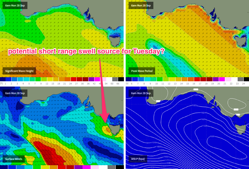
The trough’s development is also under consideration as a short range swell source. The European model has this trough forming an intense cut-off low immediately west of Tasmania on Monday morning, which - if aimed properly - could generate a sizeable SW swell for most regions. The trickiness also extends to what the low does as it intensifies: typically, it’ll slow down or possibly even stall, which may prolong a W/NW airstream ahead of the low; i.e. along the central Victorian coast. If this occurs then we could be looking at an interesting window of building short range SW swell and offshore W/NW winds in Torquay.
It's also worth pointing out that the GFS model (pictured below) doesn't quite form a cut-off low, but still has a stalled trough with some potential for short range energy on Tuesday. But the broadscale synoptic pattern is similar, and that's important.
But none of this is a certainty right now, as it only takes a small realignment of the low away from our swell window to turn a possible 3-5ft SW groundswell into a non-event. Right now we’re almost four days away from this possible scenario (i.e. Tuesday morning) so I’ll have more information about it on Monday (I’ll also update in these notes over the weekend if the models swing definitively one way or the other).
Otherwise, all eyes are still closely watching a major intensification of the Long Wave Trough over Southern Indian Ocean waters next week, which is still on target for an excellent late season Indo swell.
At this stage - and as per Wednesday’s notes - I’m not expecting this system to line up within our swell window for quite some time; it’ll probably be the following week (i.e. Oct 5th onwards) where we see any swell potential from this patterm, probably beginning with one or two westerly swells early that week, and a series of SW groundswells during the second half of the week.
As such, aside from the aforementioned cut-off feature for the first half of next week, there are no other major swell events on the cards for the second half of next week or the weekend.
See you Monday - have a great weekend!