Average end to the week, better weekend

Victoria Forecast by Craig Brokensha (issued Wednesday 2nd September)
Best Days: Monday both coasts, Tuesday and Wednesday east of Melbourne
Recap
Great clean 3-4ft waves on the Mornington Peninsula yesterday with smaller 2ft sets on the Surf Coast, suited to the beaches.
This morning the swell was smaller and only really surfable on the Mornington Peninsula with clean 3ft waves under offshore winds. Make the most of today as come tomorrow, conditions will be poor with a strong onshore change.
This week and weekend (Sep 3 - 6)
Give the rest of the week a miss, as a strong onshore S/SW change is due around dawn tomorrow with small to tiny amounts of swell.
An afternoon increase in windswell is expected, easing through Friday as SW winds persist. There's an outside chance of an early W'ly around Torquay, but with the weak average windswell it's not worth the effort.
Saturday is still the day to surf west of Melbourne, with a mix of long-range and inconsistent SW groundswell with a better and now improved short-range SW swell.
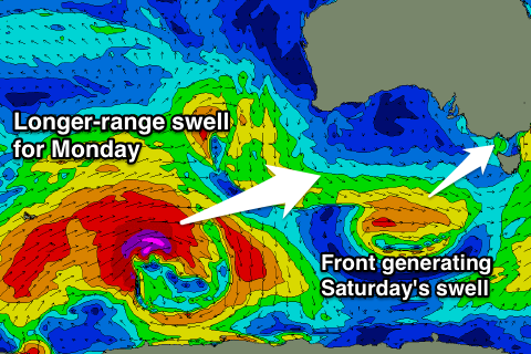 The front swinging in from under WA towards us, generating the short-range swell has been upgraded in intensity, with a fetch of strong to gale-force winds due to be produced nicely within our swell window
The size of this system now looks to be more around the 3ft range across the Surf Coast and 6ft on the Mornington Peninsula, with morning W/NW winds, swinging onshore throug the day.
The Mornington Peninsula will get its turn on Sunday as the mix of swells ease from 4-5ft (2ft to maybe 3ft on the Surf Coast) under fresh N/NE tending N/NW winds.
Next week onwards (Sep 7 onwards)
The long-range and inconsistent but strong W/SW groundswell due into early next week is still on track, with a vigorous polar frontal progression due to fire up around the Heard Island region this evening and then aim a fetch of severe-gale to storm-force winds through our far western swell window over the coming days.
This should produce a very inconsistent but strong W/SW groundswell, with the long-period forerunners arriving Sunday but with no real size, ahead of the bulk of the swell Monday, peaking through the middle of the day/afternoon to an infrequent 3-4ft on the Surf Coast and 6ft to occasionally 8ft on the Mornington Peninsula.
Also in the mix though will be some short-range W/SW swell for the afternoon, from a weak cut-off low pushing in from the west over the weekend. This doesn't look to be above the groundswell size, but is causing out models to over forecast Monday evening.
Winds Monday look to swing from the W/NW to W/SW which isn't the best, with similar conditions Tuesday. We'll have a closer look at this on Friday.