Long Wave Trough comes to town

Victoria Forecast by Craig Brokensha (issued Monday 27th July)
Best Days: Tuesday morning Surf Coast, Wednesday both coasts (east of Melbourne in morning), Thursday both coasts, Friday Surf Coast, weekend onwards Surf Coast
Recap
Saturday was clean but small across the Surf Coast, and not too interesting at all. Sunday started slow at dawn, but through the day a larger and powerful W/SW groundswell filled in as winds remained favourable for protected spots on the Surf Coast and from the W/NW-W.
A peak was seen overnight, but a secondary S/SW groundswell pulse this morning kept 6ft+ sets hitting the Surf Coast with 10ft waves on the Mornington Peninsula under W/NW breezes.
This week (Jul 28 – 31)
The weekend's and this morning's swell will continue to ease through tomorrow with morning W/NW winds on the Surf Coast and bumpy conditions to the east. The Surf Coast should ease from 3-4ft with 6ft+ sets on the Mornington Peninsula.
Wednesday morning will be a low point in size, but into the afternoon/evening, two pulses of mid-period and long-period SW groundswell are due to fill in.
These swells have been generated by a strong polar frontal progression that's developed along the polar shelf the last couple of days, with currently a fetch of severe-gale W'ly winds being generated in our south-western swell window.
The swell should build strongly through the mid-late afternoon, reaching 3-4ft on the Surf Coast and 6ft to possibly 8ft on the Mornington Peninsula before peaking overnight and easing from 4-5ft and the 8ftr range respectively Thursday morning.
Winds on Wednesday should be favourable and offshore from the N/NW all day, with stronger N/NW winds through Thursday, that may tend N'ly early across the coast.
Come Friday the swell will be smaller and with fresh to strong NW winds, the Surf Coast will be the pick, best early.
 This weekend onwards (Aug 1 onwards)
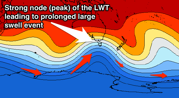
As touched on last update, we've got a larger SW groundswell on the cards for this weekend/early next week, in fact three, all due to a strengthening node of the Long Wave Trough pushing in from the west.
This will direct a series of vigorous polar fronts up towards us through the end of the week and weekend, with three successive fetches of severe-gale SW winds due to be aimed through our swell window, tending more southerly each time.
An initial pulse of large SW groundswell is due to build Saturday afternoon and peak early Sunday, with a secondary S/SW groundswell pulse for late in the day Sunday and then third S/SW groundswell pulse for Monday.
Each pulse at this stage looks to be in the 6-8ft range for the Surf Coast and 10ft+ on the Mornington Peninsula, with bigger bombs likely at times across swell magnets.
Winds look great for the Surf Coast and offshore from the W/NW tending W/SW Saturday, NW Sunday and then NW ahead of a SW change Monday.
We'll have a closer look at the timing, size and local winds on Wednesday though.
Comments
2015 is the year of the Victorian weekend warrior! I was hoping the LWT would move to midweek cycles but it seems the best conditions have been favouring the times with the biggest crowds.
True that mackdog. The weekend crew have been lucky bastards this year. off shores and not too big to make it hard to get off the beach. The only problem is the lineups have been filled with spuds who toss their boards rather than duck diving a four footer. And as for the muppets who can't get to their feet and just toss their boards over the Winki lip, go to Lorne and get yourself a G board.
Its looks like a steeper node 1st of August on WZ...? Onwards
http://www.weatherzone.com.au/models/?lt=hemisphere&lc=sh
Yeah Welly, that's the one above, Sunday night.
oooPps sorry Craig;)
These pictures look great, when are we gonna get them on SN, Looking forward to the new updates, love the LWT's.
Not sure about NZ snow on this system tho keen to fly.....?
Bloody Hell !!
Hi Craig,
Just wondering this probably requires a complex answer how does the surf coast get huge swells bigger than 6-8ft I no there are very rare but is just because of a bigger storm or something much more complex
Thanks
The more south in the swell, the more chance for more size across the Surf Coast, but also yes, the strength of the storm and its position in Victoria's swell window has to be quite incredible to see 8-10ft or more size.
From what i can gather Easter 81 wasn't as such . And off the top of my head that was the cleanest big swell they've had . Though i here whispers of something in the sixty's but you can never tell if they were straight in those days !?
Yes, for sure it doesn't have to follow the above, any huge frontal progression in the south-western swell window with strong prolonged core wind speeds to help produce a large long-period groundswell will do.
Epic '91 Swell. The one Jonny Utah scored after hopping of the train in Torquay.
Easter 81 was the biggest I had surfed, by a long shot, and is still amongst the biggest waves I've surfed.
Quite a few years ago, I was interested in finding out why that was so big, so I emailed BOM to see if they had any charts back from the weeks leading up to Easter Saturday. They sent through a few days' worth, but that was back in the analog days, and the images were quite poor. I don't know if I've still got them. Anyway, from what I remember, they showed a large low sitting south of the Bight for several days with fronts spinning out from it regularly, but I don't think it was notably intense. It just sat in the ideal position for a few days.
However, this was not the biggest swell. Around then (within a few years before or maybe after) there was another huge swell on ANZAC Day - I remember seeing a pic in Tracks of an epic bottom turn by a kneelo at Bells on a wave as big as any I saw on Easter Saturday. I had read that Rod Brooks rode a wave on a reef way outside that was reportedly over 25 feet ( I presume wave face). And wasn't there huge waves at a Bells Easter contest in the 60's?
They just don't make swells like that any more ;-)
Crip. I've seen the 4 day pressure charts for the easter 81 swell. The swell came from an enormous low (bigger than Australia), and the centre seemed to be way under SA. The isobars were so tight at the bottom of the charts, basically a thick black line showed the pressure gradient. Easter 1965 was also huge.
I think your maybe talking about Anzac day 78 or 9 Crip, surfed t in the morning , just 4 of us. Brutus, lynch and some old bloke in his late 20's, it was big with a stiff wind on it , had a couple of waves and was just paddling out to where the other guys were heard the word fuck and followed them frantically paddling for the horizon, made it over half a dozen before I got lip launched backwards(back then I had never heard of Duck diving) got bulldozed all the way to the beach.:-))))
My dad took me to watch a comp that MP won think Midget came second that was big and glassy early 70's.
"Though i here whispers of something in the sixty's but you can never tell if they were straight in those days !?"
hahaha "The mind always bends just like the waves of emotion;)....."
And this is why all nodes seem to intensify .

Question. This AAO. Where is it actually measured? Over Australia or out in the Indian Ocean or Southern Ocean. Surely it's measured in a specific longitude?
That's what I struggle with Don, it's supposed to be a whole southern hemisphere index, so how can you relate it to one longitudinal range like over Australia.
It's an expansion or retraction of the polar westerlies, and where this occurs, could be anywhere from South Africa to South America.
Well then that's shit!!! Thanks for the quick reply though Craig.
Still trying to understand why the Indian Ocean is so dead these last two weeks and wondering if there's any break in the drought on the horizon as I'm up there in just under 3 weeks!!!
Amen to that...its been 2-4 foot since muzza swell Don. Start burning some effigys or something in prep for your trip. Going to have to come to vicco to get waves
Yeah, the longer the average spell continues, the closer we have to be getting to it breaking! Hopefully.
Just to be clear, I am not responsible for this spell. Any resemblance to real persons, living or dead, is purely coincidental.
The lower Indian Ocean / Southern Ocean below has not much SST variation or larger anomaly variances ( ie extra cool /adjacent extra warm ) in the last few weeks . So I take that as less seeding , temp contrasts as lows progress East . This has to do with the ACW .
The AAO or SAM index shows when the overall surface area or nodes expand . The frequency , rhythm and cyclical effect of the nodes is more complex . Often the SAM diving strongly negative can do crazy things to the amplitude , centricity and even nodal distribution .
I however don't think this one in particular isn't exceptional for VIC .
Southey will you attack the mountains in that long john, jean short nipple hugging costume of yours....?
Looks good nah, yeah.......!
SN Models now saying 10m yikes
This could potentially be an all time weekend for the surf coast.
Am I right?!
wrong goofy foot. It's all going to be wednesday thursday this week. Get you fill buddy. Going onshore from then on.
NW Sunday?
No chance. Easterly Devil wind. Better on PI.
You're losing your touch, VL. You used to be a much better shit stirrer than this.
Cmon thermalben. calling a devil wind on Sunday is pure genius. you should give me a job as a guest reporter/forecaster.
Cheers VL
Should be a good size too for woolamai you reckon?? Few 3 footers eh?
Ps. Do you know a bloke called Shaun?
woolamai might be a bit too small. Probably be ok on the low tide but too full on the high.
Shaun? I know a few Seans but no Shauns. Sean Connery, Sean Penn, Sean the sheep. All good people (Except Sean the Sheep who is a sheep not a person) who surf with their left foot forward.
The low / evolving lows that caused the 81 swell , had origins in the Kerguelen Islands .
Quite similar to the last big Indo / swell , but instead of it peaking out there , the low kept marching East and intensified due to it drawing down a cyclone " Olga " from up near the Cocos islands . Although it didn't totally consume the ex cyclone it then dragged it direct East towrds Perth . The cyclone was very weak at this stage , but no doubt the tropical mass helped maintain the the upper support feature and the low maintained an extremely strong fetch . And we had a captured fetch scenario , once it reached below the WA /SA border , the low then stalled and rotated on itself , which provided the relatively light local offshore breezes early in the day . The other scenario that may have helped is that year there was quite high tides . The highest ever recorded tide ( although accompanied with a storm surge ) was recorded a month or two later .
Welly , not too sure on the Infeeds for this system , but yeah I'm getting antsy . Not sure the nipples will bust out though . That's more spring getup . That and I'm waying up a late season surf trip in Sept .
Where you goin in sep?
"not too sure on the Infeeds for this system , but yeah I'm getting antsy ."
Uumm I can kind of see for Oz.
I'm looking at more across the ditch! looks like a great setup at the mo! Will see.
A really great deep low with NW-W, moisture and a cold deep south fetch way below
Real low barometric pressure drop on land;)