Exposed spots the pick tomorrow, better swell Sunday/Monday with deteriorating winds

Victoria Forecast by Craig Brokensha (issued Wednesday 22nd July)
Best Days: Thursday both coasts, Friday morning east of Melbourne, Saturday for keen surfers on Surf Coast, Sunday morning Surf Coast, early Monday around Torquay for keen and experienced surfers
Recap
A fun pulse of SW groundswell came in around forecast yesterday with inconsistent but good 2ft to occasionally 3ft waves at exposed spots on the Surf Coast with 4-5ft sets on the Mornington Peninsula under strong N'ly winds.
The swell eased a touch into the afternoon, while this morning, the surf was effectively flat on the Surf Coast and an inconsistent and clean 2-3ft on the Mornington Peninsula.
A slight kick in W/SW swell is due this afternoon as winds tend more NW. The Surf Coast may see the surf increase to 1-2ft late, but I wouldn't count on it.
This week (Jul 23 – 24)
Tomorrow should provide more size across both coasts, but keep your expectations low west of Melbourne. A new westerly swell is due to fill in through the day, generated by a broad but relatively weak cold front pushing up and into WA the last couple days.
This should offer inconsistent 2ft sets on the Surf Coast with 4-5ft+ waves on the Mornington Peninsula with local morning offshores across both regions, tending more NE into the afternoon.
A drop in size is due Friday leaving easing 1-2ft sets on the Surf Coast and 3-4ft+ waves on the Mornington Peninsula with fresh to strong N/NW winds (N'ly early east of Melbourne).
This weekend onwards (Jul 25 onwards)
 Our slightly better pulse of W/SW groundswell due Saturday isn't looking as good any more, with similar sized waves to Thursday due across both coasts.
Fresh NW tending stronger N/NW winds will favour the Surf Coast, but again keep your expectations low.
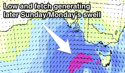
Sunday will be the day to surf, with a mix of better W/SW groundswell and building short-range W/SW swell as a vigorous frontal system pushes in from the west.
The Surf Coast should be around 3-4ft during the morning, pulsing towards 4-5ft+ later in the day, with the Mornington Peninsula increasing from 6ft+ to 8ft+ into the afternoon.
Fresh to strong W/NW tending W/SW winds will favour the Surf Coast and create poor conditions east of Melbourne.
A peak in size is due Monday morning out of the SW, with the strongest part of the low directing a fetch of severe-gale SW winds up towards us Sunday.
This should come in at a good 6ft across the Surf Coast with 8-10ft sets on the Mornington Peninsula early, dropping rapidly through the day and further into Tuesday.
Winds will unfortunately be fresh to strong but easing from the SW, with only a slim chance for an early W'ly around Torquay.
Tuesday looks a touch better with lighter SW winds and a W/NW'ly more than likely through the morning around Torquay.
Longer term, a small pulse of SW groundswell is due Wednesday afternoon ahead of a larger pulse of long-period SW groundswell Thursday, generated by a strong but distant polar frontal progression firing up in the Heard Island region Saturday, pushing east closer to us through early next week.
A moderate to large sized SW groundswell is on the cards at this stage with likely north-west winds, but we'll have a closer look at this on Friday.
Comments
Craig could be options east. Not too big?
When is this Memla?
Saturday. Looks a touch under 6 foot which is borderline but with a strong northerly and a good bank could be OK
Thought on getting a wave East of Melbourne Saturday morning Craig? Was thinking the Island might be worth a drive.
No go, winds average until late afternoon.
Thanks Craig, I was living in the faint hope that you might tell me something different. West coast bound it is then.
Just looked at rye and gunna. Solid 6ft+ sets pretty consistently. Must have picked up a fair bit since this morning
Yeah Point Nepean obs are nice. 3ft easy at 13th Beach now as well.
And re question below, a lot of windswell contamination in the model forecasts through Bass Strait. The low has been upgraded in intensity though, with core wind speeds now due to reach near 60kts!
Also what's the go with the models for this weekend saying it's meant to be 15ft?
Thanks Craig.
I'd hate to be bobbing around in bass straight at the moment!