Fun from Sunday, more so exposed coasts early next week

Victoria Forecast by Craig Brokensha (issued Friday 17th July)
Best Days: Sunday, Monday through Wednesday east of Melbourne, Thursday both coasts, Friday morning Surf Coast
Recap
Poor conditions yesterday with an average easing swell and moderate to fresh S/SE wind, and then a new SW groundswell today but with SW winds.
This weekend and next week (Jul 18 – 24)
Tomorrow's mix of SW and S/SW groundswell have been upgraded a touch further from Wednesday, with the polar frontal progression generating the swell forming favourably in our swell window.
We should see the Surf Coast offer better 3-5ft sets with 6ft to occasional 8ft waves on the Mornington Peninsula, but with a moderate to fresh S/SE wind. This should ease through the day although the afternoon will still be poor.
Sunday is still the day to surf, as Saturday's mix of swells eases from 3-4ft on the Surf Coast and 5-6ft on the Mornington Peninsula under local offshore winds through the morning, tending more variable from the W into the afternoon.
Monday will be smaller again, and best east of Melbourne with local offshore winds holding from the north all day.
 Our small kick in SW groundswell for Tuesday morning is still on track, with an intense but unfavourably tracking low due to form today and track south-east while generating a fetch of severe-gale to storm-force W'ly winds perpendicular to our swell window.
Still the strength of the low should produce a pulse of SW groundswell for on dark Monday, easing Tuesday morning from 2ft+ on the Surf Coast and 3-5ft on the Mornington Peninsula. Conditions should remain clean with a fresh and gusty N/NW tending N'ly breeze (N'ly all day east of Melbourne).
Wednesday will again be best east of Melbourne with a small and flukey W'ly swell not really getting into the Surf Coast, while the Mornington Peninsula should offer sets around 3-5ft with a fresh but easing N'ly breeze.
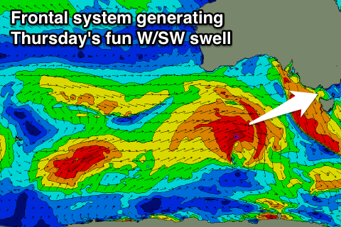
The end of the week is looking better, with a stronger polar front due to push up towards WA and then south of the Bight through early next week, aiming a fetch of W/SW gales through our western swell window.
This should produce a moderate sized W/SW groundswell for Thursday, coming in at a fun 3ft+ on the Surf Coast with 4ft sets at swell magnets, and 6ft+ on the Mornington Peninsula with the odd 8ft bomb.
Winds at this stage look good for both coasts through the morning with local offshores, before tending N/NE into the afternoon. A drop in size is then due Friday as winds tend NW.
Longer term there's still nothing too significant on the cards, with small to moderate W/SW pulses due into next weekend and beyond. More on this Monday though, have a great weekend!