Poor until Sunday

Victoria Forecast by Craig Brokensha (issued Wednesday 15th July)
Best Days: Sunday, Monday exposed spots, Tuesday morning
Recap
Good day of waves across the Surf Coast yesterday with a mix of swells to 3-4ft, with offshore winds most of the day, tending a little less favourable from the N'th into the afternoon.
This morning a better pulse of SW groundswell has come in at 3-5ft on the Surf Coast and 8ft on the Mornington Peninsula with light variable tending offshore winds as a cut-off low stalls to our west. Winds should remain variable for most of the day, before increasing from the SE late afternoon as the low moves in from the west.
This week and weekend (Jul 16 – 19)
The next three days are looking poor, with an easing swell and moderate to fresh SE tending S'ly winds tomorrow and then a good new pulse of SW groundswell Friday but with fresh SW breezes.
This groundswell will be the first of two, generated by a strong pre-frontal fetch of W/NW winds moving through our far swell window, followed by a secondary intensification to our south-west today and tomorrow.
Both swells look to come in around 3-4ft across the Surf Coast and 6ft+ on the Mornington Peninsula, but as above winds will be average Friday and SE winds winds again Saturday.
 There is a slim chance for an early W'ly around Torquay Friday morning, but you'll have to keep an eye on local observations again.
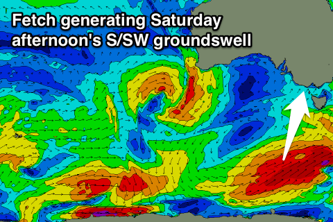
Also in the mix Saturday afternoon should be a new S/SW groundswell from a strengthening fetch of SW gales late in our swell window tomorrow afternoon and Friday, projecting towards Tasmania. This will keep the surf up all day, before easing Sunday.
Sunday will be the cleanest day to surf, as an approaching front swings winds offshore from the N/NW on the Surf Coast and N/NE on the Mornington Peninsula, tending variable into the afternoon.
Size wise, the Surf Coast should ease from 3ft+, with 5-6ft waves on the Mornington Peninsula.
Next week onwards (Jul 20 onwards)
Monday will be better across exposed locations across the state with the swell easing from a smaller 2ft on the Surf Coast and 3-4ft on the Mornington Peninsula under fresh N'ly winds.
A slight kick in long-period but tricky SW groundswell is due Tuesday, from a very strong but very unfavourably tracking low, developing south of WA and pushing south-southeast while generating a fetch of severe-gale W'ly winds.
A small kick to 2ft+ is due on the Surf Coast Tuesday morning, with 3-5ft sets on the Mornington Peninsula, easing into the afternoon under N-N/NW winds.
Longer term some small to moderate and patchy W/SW swell is on the cards for Thursday/Friday, but to no major size or strength. We'll have a closer look at this Friday.