Great outlook for the Surf Coast

Victoria Forecast by Craig Brokensha (issued Wednesday 1st Jul)
Best Days: Friday through Monday Surf Coast, Mornington Peninsula Saturday morning, Sunday and early Monday
Recap
Moderate amounts of reinforcing W/SW groundswell kept good 3-4ft waves hitting the Surf Coast most of yesterday with favourable winds, while the Mornington Peninsula was larger but only really decent around Flinders.
Today a slightly stronger W/SW groundswell has peaked, with 3-5ft sets on the Surf Coast and 6ft+ sets on the Mornington Peninsula under great winds for locations west of Melbourne. The swell should ease through the day as winds persist from the NW.
This week and weekend (Jul 2 – Jul 5)
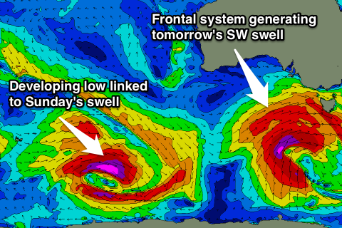
Tomorrow's building SW groundswell has been upgraded a touch but the winds are still looking poor.
A vigorous and strengthening frontal system currently to our south-west is aiming a fetch of gale to severe-gale W/SW winds through our swell window. This system will push up and into us today and tomorrow, with a trailing fetch of S/SW gales remaining in our swell window down to the polar shelf through tomorrow morning.
A large SW groundswell pulse is due into tomorrow afternoon, before easing from the S/SW Friday, with the Surf Coast due to build to 4-6ft tomorrow afternoon, with 6-8ft+ sets on the Mornington Peninsula, easing back from 4-5ft and 6-8ft respectively Friday.
 Conditions tomorrow will be poor as the change pushes through with strong but easing SW winds across both coasts. The chance of an early W'ly around Torquay is quite slim, as the change proper is due through at dawn.
Friday will be great though as another front quickly approaches from the west resulting in winds swinging offshore from the NW during the morning, increasing a touch from the W/NW into the afternoon.
Saturday will be fun but smaller as we fall in betweens swells, but there should be 3ft sets on offer most of the day across exposed spots on the Surf Coast and 4-6ft waves on the Mornington Peninsula. A late increase in new SW groundswell due Sunday may be seen, and winds should be favourable and offshore from the N/NW tending NW, ahead of a possible late and shallow SW change.
Sunday's swell will start to be created today, by a strong polar low firing up south-west of WA today before pushing slowly east and then north-east towards Tassie while continuing to generate a fetch of gale to sometimes severe-gale W/SW winds.
A good S/SW groundswell should result, possibly showing later Saturday and peaking through Sunday morning to 4-6ft on the Surf Coast and 6-8ft on the Mornington Peninsula under fresh but easing N/NW winds. Winds may even hold from the N'th all day Sunday east of Melbourne opening up plenty of options for experienced surfers.
Next week onwards (Jul 6 onwards)
Monday should see Sunday's S/SW swell easing away from 3-4ft on the Surf Coast and 6ft+ on the Mornington Peninsula with stronger N/NW tending W/NW winds.
There's nothing too significant on the cards for the rest of the week as a broad upper level blocking pattern moves in from the west next week (opposite to the LWT) so make the most of the coming period of waves!