Good pulses of swell but with deteriorating winds

Victoria Forecast by Craig Brokensha (issued Monday 18th May)
Best Days: Tuesday, early Wednesday, Saturday, Sunday
Recap
Super fun weekend of waves across both coasts with a mix of swells to 2-3ft on the Surf Coast and 4-5ft on the Mornington Peninsula with light local offshore winds. A strong but inconsistent and new SW groundswell pulsed through the afternoon with bigger sets across both coasts before easing from 2-3ft (bigger at Bells and Winki) and 4-6ft Sunday morning with local offshores.
Today the swell was easing further from 2ft and 3-4ft respectively under persistent offshore winds.
 This week (May 19 - 22)
As touched on Friday, we've got some good pulses of groundswell on the cards for this week, but unfortunately winds will go onshore from Wednesday and persist into the weekend.
Tomorrow is still looking fun with a peak in new S/SW groundswell generated by a vigorous polar front over the weekend.
This should come in at an inconsistent 3ft+ across exposed breaks on the Surf Coast and 5-6ft on the Mornington Peninsula. Conditions should be good with local offshore winds from the north that are then expected to become more variable from the N/NW into the afternoon.
Into Wednesday afternoon a stronger pulse of SW groundswell is due, from a vigorous polar frontal progression that's currently to the south of WA, with it forecast to project towards us through this evening and tomorrow.
The swell should build through Wednesday and reach 3-5ft into the afternoon with 6-8ft sets on the Mornington Peninsula but right as a surface trough pushes in from the west, bringing a gusty S'ly change late morning.
Before the change winds should be light offshore but the swell will be small.
A slight drop in size is due into Thursday but winds will persist from the S/SE.
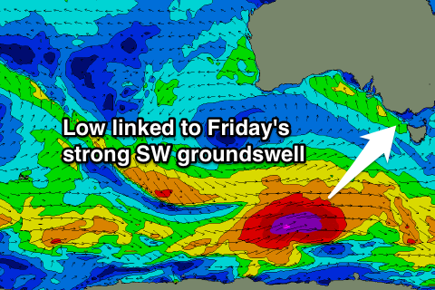
The next pulse of SW groundswell is due on Friday, with another polar low generating a fetch of severe-gale W/SW winds through our swell window mid-week, producing a strong long-period SW groundswell for Friday morning.
This should come in at 4-5ft on the Surf Coast and 6-8ft on the Mornington Peninsula but with a lingering and fresh S'ly winds, creating poor conditions.
This weekend onwards (May 23 onwards)
Friday's swell should ease through the weekend with a couple of smaller reinforcing SW groundswells due through Saturday and Sunday, keeping exposed spots active.
Winds will improve but possibly linger from the SE Saturday as the swell drops from 3-4ft and 6ft+ respectively, while Sunday should see easing 3ft and 5-6ft waves respectively with a better N'ly breeze.
Longer term there's nothing too significant on the cards, but we'll have another look at this on Wednesday.