Large swells continue

Victoria Forecast by Craig Brokensha (issued Friday 8th May)
Best Days: Surf Coast Saturday, Sunday morning, later Monday, Tuesday morning
Recap
Another excellent day of clean 4-6ft reef waves across the Surf Coast, becoming slightly wind affected into the afternoon. Today the swell has held the 4-6ft range with a perfect offshore NW wind, and we should see conditions remaining clean into the afternoon as the swell starts to drop.
 This weekend and next week (May 9 - 15)
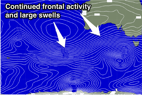
Today a mix of W/SW and SW groundswell are in the water, generated by a vigorous polar low that was positioned to our south-west yesterday.
This low has since moved out of our swell window but a new strong polar low is currently moving into its place.
With this we should see today's mix of swells easing into this afternoon and early tomorrow morning before a new pulse of large SW groundswell builds through the afternoon.
This should see the Surf Coast building back to 4-6ft through the late afternoon from the smaller 4ft range through the morning and then peak overnight. The Mornington Peninsula should build to the 8-10ft range late in the day but conditions will be poor with a persistent and fresh NW wind.
Saturday's late kick in swell will be replaced by a new large W/SW groundswell Sunday afternoon and then bigger pulse Monday morning.
Again these will be generated by a couple of vigorous frontal systems pushing up and into us through Saturday and Sunday, with the Surf Coast due to build from 4-5ft Sunday morning with 6ft sets showing later in the day. Winds will be good through the morning with a fresh to strong NW breeze ahead of a W/SW change through the day.
Come Monday we're now looking at larger 6ft+ surf west of Melbourne (8ft sets at Bells and Winki) with 10-12ft waves on the Mornington Peninsula as a vigorous cold front slams into us overnight and early in the morning. The only problem looks to be the winds and they're due to swing strong to gale-force onshore from the W/SW around 7am, easing through the day. This will create generally poor conditions across all locations. Late in the day we'll likely see winds tend back to the W/NW, so keep an eye on conditions for a late paddle.
Tuesday should be smaller on the backside of the swell under strengthening W/NW winds.
Now, into Tuesday afternoon and Wednesday the American model GFS is going ballistic with a very strong and intense cut-off low currently forecast to project a fetch of severe-gale to storm-force W/SW winds up and into us. If this came off in its current form we'd see 8-10ft surf on the Surf Coast overnight Tuesday and early Wednesday, but the other models EC and ACCESS are showing a lot tamer system.
With this in mind I'll keep a reign on the forecast expectations for later Tuesday and Wednesday and put it more in the 6ft range again. Well have to have a last look at this on Monday though. Winds look average in any case and from the SW, but more on this Monday. Have a great weekend!
Comments
Nice lineup from this morning taken by mick-free..
Hi Craig,
The forcast has mornington peninsula on Tuesday at 15ft in the afternoon do you reckon that's unrealistic
Cheers mate
Hi Nick,
I discussed this in the last two paragraphs. On the 18z GFS model run, no not unrealistic, but the other models were much weaker.
The latest EC data has come in and it's strengthened the low, and GFS is holding so probably looking at more confidence in the larger size range. Probably 8ft Surf Coast and 12ft Mornington Peninsula.
Yeeew! How good is that photo of winkis! Been a hard week seeing that the waves have been pumping, but plenty of time to charge my go pro and get everything ready for the weekend. I'm so excited about tomorrow. Your forecasting has been spot on this week Craig! Your doing a 'swell' job haha! Do you think it could get big enough for the bells bommie in a few days? I've heard that only breaks when it's bigger than 15ft? Probably too big for me but be good to watch. I'm even thinking about buying a gun with a pin tail for the bigger days. Be cool to own a quiver! Anyway, thanks for the forecast update, gonna be a good weekend!
can't quite tell if he is serious of trolling
Hey Craig, pumping waves on the surfcoast today yeew! Do you know what time the wind is expected to go onshore tomorrow? Do you think it will be good anywhere early? I'm hoping to get another tube in the morning at winkis
.