Average until Friday

Victoria Forecast by Craig Brokensha (issued Monday 20th April)
Best Days: Wednesday morning for keen surfers, Thursday from mid-morning for keen surfers, Friday, Saturday morning, early Sunday around Torquay
Recap
Excellent waves on the Surf Coast Saturday with a clean easing 3-4ft of swell under offshore winds that persisted until a late afternoon onshore change moved through.
Come Sunday a large and powerful W/SW groundswell filled in but with fresh onshore winds which made it hard to pick the real size. Reports of 6ft+ waves on the Surf Coast and 10-12ft sets on the Mornington Peninsula sound around the mark, but only super protected spots offered any real decent options for a surf.
Today the swell has dropped back more than expected with onshore 3-4ft waves on the Surf Coast and 6ft+ sets on the Mornington Peninsula under a moderate to fresh S/SE breeze.
 This week (Apr 21 - 24)
We've got an average week ahead with persistent onshore winds linked to a deepening East Coast Low off the NSW coast.
This low will sit south of Sydney nearly the entire week with a weak onshore southerly pressure gradient extending over our state until about Friday.
With this we'll see onshore winds through tomorrow from the S'th before becoming lighter from the S/SE into Wednesday. A moderate SW groundswell is due through tomorrow before easing Wednesday from a frontal system currently to our south-west and this will keep 3ft sets hitting the Surf Coast and 5-6ft waves on the Mornington Peninsula.
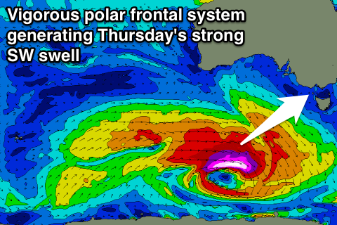
A low point in swell is due early Thursday before a new long-period SW groundswell arrives mid-late morning and peaks into the afternoon.
The source of this swell will be a vigorous polar frontal system firing up south-west of WA today, aiming a fetch of severe-gale W/SW winds through our western swell window with stronger storm-force winds at its core. The front will track a little unfavourably to the east-southeast as it pushes under the country, but we'll still see some strong swell spreading up radially into us for Thursday.
The Surf Coast should build to 3-5ft with 6-8ft surf on the Mornington Peninsula and there should be some OK options with a lighter SE'ly, but keep your expectations low.
Friday will be the day to surf though with an easing swell from 3-4ft on the Surf Coast and 6ft+ on the Mornington Peninsula under N/NW tending W/NW winds. Locations east of Melbourne should see a better N'ly for the first few hours of the morning.
This weekend onwards (Apr 25 onwards)
The weekend is quite dynamic as we're expected to see a smaller SW groundswell fill in from the backside of the strong frontal progression moving through this week, as well as a larger short-range swell from a deepening mid-latitude low.
This low is forecast to form under South Australia on Friday and move slowly east while aiming a fetch of severe-gale W'ly winds through our western swell window.
The low itself is due to move across us through Saturday and with this we'll see a large kick in W/SW swell, building to the 5ft range on the Surf Coast and 8ft range on the Mornington Peninsula but with onshore SW winds. The models are still a little divergent surrounding the timing and size of this swell so we'll have to review this again Wednesday and Friday.
Come Sunday the swell is due to ease under W/SW winds (likely W/NW around Torquay through the morning).
Longer term there's nothing too significant on the cards but we'll review this Wednesday.
Comments
Hey Craig - I'm in King Island Fri-Sunday.
Any idea what we might be in for from a swell and conditions perspective?
Cheers
Jay
Well Jay, not as good as what went down yesterday, but you should get some decent waves late in the day Saturday and early Sunday with the close-range swell from that low.
Good winds for that well known beachy for now, but it may shift around still over the coming days.
If that low stays any further north, the swell potential will be downgraded considerably.
I saw some pictures of guys surfing at St Kilda on Sunday!
Can you put those photos up whatsyrexcuse
Also Craig just got a small question the surf forcast is saying Saturday will be northerly all day do you think that is accurate since you said there should be onshores for Saturday in this forcast note?
Thanks
Hi Frenchy,
Yeah the low is forecast to be positioned more north and west through Saturday now resulting in those N'ly winds.
Swell will be smaller as well now with the fetch from the low being aimed into SA and out of Viccos swell window.
Thanks for the info Craig. Any other spots that aren't overrun with frothers that you'd like to share with the group?
Bells and winki will be offshore, but shhhhhhhhh