Exposed spots until Thursday, large swell for Sunday

Victoria Forecast by Craig Brokensha (issued Monday 13th April)
Best Days: Tuesday and Wednesday morning exposed breaks, Friday both coasts, Saturday Surf Coast, early Sunday Torquay
Recap
Fun waves across both coasts Saturday with an easing and clean 2-3ft of swell across the Surf Coast and slightly bumpy 3-5ft sets on the Mornington Peninsula.
Sunday was poor with a small leftover swell and onshore winds, but a new inconsistent SW groundswell built through the afternoon offering more size for desperate surfers.
Today a new S/SW groundswell has kept good 3ft sets hitting the Surf Coast with 3-4ft waves on the Mornington Peninsula under light local offshore winds. The swell should persist all day as SE sea breezes kick in.
 This week (Apr 14 - 17)
There's nothing major on the cards this week until Friday. Today's pulse of S/SW groundswell will ease through tomorrow and become small to tiny Wednesday but with favourable winds for exposed breaks.
The Surf Coast should ease from 2ft tomorrow with 3ft to possibly 4ft sets on the Mornington Peninsula early under N/NE winds. Wednesday will then be tiny on the Surf Coast and a small 2ft+ on the Mornington Peninsula with a N/NE tending N/NW breeze ahead of a late W/SW change.
Thursday will be a lay day with minimal amounts of swell and fresh SW winds across most spots, although Torquay may see an early W/SW'ly but it'll be tiny.
Into Friday a very inconsistent long-range W/SW groundswell is due through the morning ahead of a better and more consistent W/SW groundswell pulse through the afternoon, holding into Saturday morning.
This will be related to a strong node of the Long Wave Trough moving in from the west over the coming week, with the first inconsistent W/SW groundswell pulse associated with it being generated in our far swell window in the southern Indian Ocean.
The size off this swell will be limited with a very infrequent 2-3ft wave due across swell magnets on the Surf Coast with 4-5ft sets on the Mornington Peninsula.
A stronger polar low firing up south-west of WA tomorrow will generate a fetch of severe-gale W/NW and then W/SW winds in our swell window, producing a better pulse Friday afternoon reaching 3-4ft west of Melbourne and 6ft to occasionally 8ft on the Mornington Peninsula.
Winds Friday morning should tend light and variable offering clean if not slightly wobbly conditions across both coasts ahead of weak afternoon E/SE sea breezes. Come Saturday an approaching front should see fresh N/NW tending W/NW winds ahead of a late W/SW change, favouring the Surf Coast.
This weekend onwards (Apr 18 onwards)
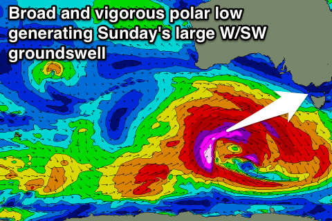
Saturday afternoon's late change will be linked to a vigorous and broad polar low pushing in from the west later in the week, aiming a fetch of severe-gale to storm-force W/SW to SW winds through our swell window, generating a large and powerful W/SW groundswell that should kick later Saturday and peak Sunday morning.
We're looking at large 6-8ft waves on the Surf Coast and 10ft sets on the Mornington Peninsula but winds will be fresh and gusty from the SW. The Torquay region should see an early W'ly but the swell will still be a little unorganised and far from perfect.
As the swell eases Monday winds are looking average and from the south, but we'll have another look at this on Wednesday.
Comments
G'day Craig
You reckon there's any chance of some nw wind Sunday morning on the surf coast?
Looking to be a nice swell but the winds are looking pretty suss
In short no unfortunately, only a very slim chance of a brief W'ly, and even so the swell will still be raw and bumpy.
No worries, cheers