Fun tomorrow morning, possible small window Saturday morning

Victoria Forecast by Craig Brokensha (issued Wednesday 7th January)
Best Days: Thursday morning, early Saturday
Recap
Yesterday was average across all locations, with the southern end of the Mornington Peninsula fairing best under the morning SE breezes.
Today conditions were cleaner and improving across both regions with lighter offshore winds on the Mornington Peninsula and more variable breezes across the Surf Coast. The swell was still small as expected to around 2ft on the Surf Coast and 3-4ft on the Mornington Peninsula, but a new SW groundswell us due to build through the afternoon (just hit the Cape Sorell buoy with periods jumping to 14s), reaching 2-3ft on the Surf Coast and 4-6ft on the Mornington Peninsula by evening.
Winds should tend variable into the early to mid-afternoon before sea breezes try to move in.
This week and weekend (Jan 8 - 11)
This afternoon's kick in SW groundswell is due to peak under darkness and then ease off slowly through tomorrow from 2ft (with the odd bigger one possible at 13th Beach early) on the Surf Coast and 3-5ft on the Mornington Peninsula.
Winds will be good and straight offshore from the N'th but with strength tomorrow morning before tending W/NW around the middle of the day ahead of a late SW change.
Therefore the Mornington Peninsula beaches will be best early to late morning and the Surf Coast cleaner longer into the early afternoon.
Friday will be a write-off with gusty S'ly winds in the wake of tomorrow evening's change with a small leftover swell and no decent size.
We're looking at a better pulse of SW groundswell on Saturday across the state from a broad but not overly strong polar front pushing from the south-west of WA towards us over the coming days.
Size wise the Surf Coast should see 2-3ft sets, with 4-6ft waves on the Mornington Peninsula and winds are looking better than they were forecast on Monday.
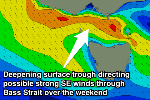 As mentioned on Monday, a tricky inland surface trough is forecast to drift south-east across the state and with this we'll likely see winds tend variable Saturday morning before strengthening from the E/SE during the day along with torrential rain across the state.
Forecasts for Sunday are all over the shop still, with the American model forecasting the trough to deepen to our south-east before drifting west, directing strong to gale-force SE winds through Bass Strait kicking up solid levels of windswell Sunday morning.
The European model however pushes the trough south-west straight away and with this we'll see E/SE tending E/NE winds and only small amounts of windswell that will fade through Monday.
Either way we're looking at average conditions Sunday and then cleaner waves Monday under morning offshores but no real swell.
Next Monday onwards (Jan 12 onwards)
The surface trough deepening over our region during the weekend will effectively block any major fronts from pushing towards us and with this we'll see only small to tiny amounts of swell into the start of next week.
Beyond this there's still nothing major on the cards showing for us, so make the most of today and tomorrow morning's waves as well as the small window Saturday morning!
Comments
How do you surf around here Shaun? If yesty evening's WAM forecast was the same as this morning, it was pretty much spot on. For E of Shaun's.
Get some fun ones west of the ranges this morning Mitch?
Hopefully this arvo Craig, keeping my expectations in check though.
Was pristine conditions before the wind went too East . Banks weren't as good as last Friday though . Today's pulse in swell ( including increased interval ) was spot on .
Unfortunately that trough stopped it staying NE . But it could provide tomoz mornings offshore for longer . Shame I couldn't hang out for the stormy glass off . That being said a few of these storm cells have created some pretty crazy gusty localised weather .
Nice, yeah hope you score tomorrow!
Hi Craig
In a word Craig, yes. I think Southey would've had fun too.
Today, the WAMs forecasts were WP 2ft, CL 3ft, Wonth. & PI 3-4ft, MP 4ft. Increasing size heading NW. With more or less the same single groundswell in the water, late yesterday and this morn we saw WP, CL (barely), VB, Cape Pat, PI. We did not see a trend which relflects trend of increasing size to the NW.
Topography and bathymetry seem pretty important here, as you'd expect anywhere. Especially when these forecast 'districts' are so specific and close by each other.