Strong swells, strong winds

Victorian Surf Forecast by Ben Matson (issued Monday 29th December)
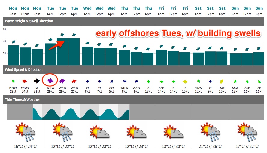
Best Days: Tues: good waves at protected locations. Wed: good surf in Torquay as the swell eases. Fri: good options east of Melbourne as winds go E'ly.
Recap: Plenty of swell over the weekend with generally light winds both days. A strong pulse of groundswell arrived during the middle of Sunday with large waves reported at exposed spots east of Melbourne. Size has eased a little today but fresh NW tending W’ly winds have favoured the Surf Coast with decent 3ft waves for the most part.
This week (Dec 30 - Jan 2)
*forecast notes will be brief this week*
Plenty of swell and wind for the next couple of days.
Tuesday’s surf will consist of a mix of long range W/SW groundswell (from a polar front that developed over the weekend) in addition to a strong local windswell generated in the wake of a strong frontal passage this afternoon and tomorrow.
The second front is due to cross Bass Strait early/mid morning, so we should see gusty W/NW winds for the dawn patrol (see graph below for TQ), with building wave heights that should reach 4-5ft on the Surf Coast by the afternoon (although probably undersized early).
This swell combo will be very large across the East Coast (~8ft) but should be sufficient enough for good small waves at Western Port in the 3ft range, with the biggest/best options expected later in the day.
These fronts will quickly clear to the east by Wednesday leaving much of the coast with light variable winds as another front rears up from the south-west. This should provide a good day of waves along the Surf Coast in the 3ft range as the swell slowly abates. Expect a few wobbles on top here and there though.
This next front won’t traverse quite as far north so winds won’t become very strong, of which the (shallow) southerly change behind it will fill in on Thursday, probably mid-late morning. Expect slightly smaller surf with light winds for the early session (probably just enough to get the Surf Coast reefs working, so worth an early New Year surf).
A small mid-range swell trailing Thursday’s change will then fill in on Friday, probably maintaining a similar size range as Thursday (inconsistent sets on the Surf Coast between 2ft and occasionally 3ft) whilst winds veer to the eastern quadrant as a trough developed over the eastern states. Therefore, the end of the week looks like it’ll favour open beaches east of Melbourne.
This weekend (Jan 3-4)
The general trend for the weekend currently looks like favouring easing swells and light offshore winds Saturday, with a southerly change and building wave heights on Sunday.
The new swell expected Sunday is expected to originate from a stalled Southern Ocean front that’s expected to temporarily stall south of the continent on Friday, before restrengthening as a polar low at a more southern latitude on Saturday.
This should provide a decent shot of SW swell through Sunday afternoon and Monday in the 3ft+ range at Torquay (and 4-6ft east of Melbourne) however we’ll have to work around the local winds, which currently look to be a little dicey (typical of sumer, to be honest). I’ll take a closer look on Wednesday with the availability of the latest model guidance.
Next week (Jan 5 onwards)
Current indications are for a temporary blocking pattern to develop south of the state over the weekend, as a series of strong fronts strengthen SW of West Oz. This suggests an easing trend following the Sunday/Monday swell - perhaps for a couple of days - before a strong SW swell pushes through during the second half of next week. More on this in Wednesday’s update.
Comments
Merry Xmas Craig, Ben and Crew!
Am i right in suspecting we'll see NE/NNE wind persist into Sat morning?
Cheers
Merry Xmas to you too Sarge. Re: winds: yeah possibly, although it'll probably straighten to the north quickly, then veer NW as a front approaches from the west.
Thanks!