Small window Wednesday morning, best Saturday

Victoria Forecast by Craig Brokensha (issued Monday 8th December)
Best Days: Wednesday morning for small beachies east of Melbourne, Saturday morning both coasts
Recap
Saturday was poor with small amounts of swell and strengthening onshores, while a solid and junky SE windswell developed into Sunday to 3-4ft across the Surf Coast with plenty of waves at funkier spots if you were keen to search around.
With the trough responsible for the SE windswell easing, the swell has also dropped back to 2-3ft across the Surf Coast today but with more S'ly winds, protected locations cleaned up and offered fun peelers. The Mornington Peninsula saw a new SW groundswell kick to 3-4ft, but conditions remained a mess with fresh onshore winds.
This week (Dec 9 -12)
The week ahead is still looking poor, but as touched on last update things look to improve late in the week, but more so into the weekend.
Into tomorrow our mix of SE windswell and inconsistent SW groundswell is due to fade with poor but easing S/SW winds. This will leave no real options for a decent wave unfortunately.
Into Wednesday morning the Mornington Peninsula and other exposed breaks should offer clean conditions with a light E/NE tending NE breeze, but the swell will be very small and only around 2ft with the odd inconsistent 3ft bomb.
Make the most of this little window though, as a trough moving across us into the evening will bring poor and fresh S/SE winds into Thursday.
Friday will be better but still poor as winds swing to the E/SE and remain fresh as the swell remains small through the morning ahead of a late kick in new SW groundswell.
 This weekend onwards (Dec 13 onwards)
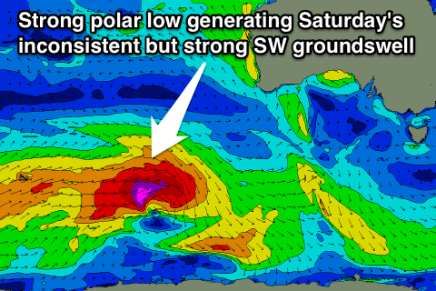
Friday's late kick in SW groundswell will be the fore-runners of a larger kick in size through Saturday from a flurry of strong polar activity under WA and the country this week.
An initial fetch of W/SW gales today will set in motion an active sea state for a stronger polar low to move over, producing an additional fetch of severe-gale W'ly winds before the system tracks east-southeast and under Tassie.
This should produce a strong but inconsistent SW groundswell for Saturday. The Surf Coast is expected to offer inconsistent but good 3ft+ sets, while the Mornington Peninsula will be solid and in the 5-6ft+ range.
Conditions will be good across both coasts as well with an approaching trough expected to swing winds around to the north, locally offshore before an afternoon S/SW change pushes through.
In the wake of the change conditions will be poor again into Sunday and early next week, but more on this Wednesday.