Great end to the week, limited windows over the weekend

Victoria Forecast by Craig Brokensha (issued Wednesday 29th October)
Best Days: Thursday Surf Coast, Friday both coasts, Saturday morning and early Sunday Surf Coast, Monday morning both coasts, Tuesday east of Melbourne
Recap
Yesterday started out slow with a small 2ft+ wave across the Surf Coast under fresh to strong W/NW winds, while the Mornington Peninsula offered more size to 6ft+.
During the afternoon though a strong and powerful SW groundswell filled in although protected breaks on the Surf Coast offered the only decent conditions with a fresh to strong W/SW breeze.
This morning though, we woke up to one of the better mornings for a long while across the Surf Coast, with clean, straight, pumping 6ft+ surf across the reefs under offshore winds.
The swell will drop quickly through the day with a possible moderate W/SW'ly late afternoon, so make the most of this morning's waves!
 This week (Oct 30 - 31)
While this morning was the pick of the week, we've got plenty of good waves due over the next two days.
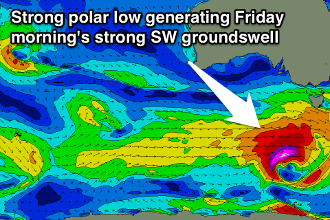
The swell will drop back to the 3ft range tomorrow across the Surf Coast and 5-6ft sets on the Mornington Peninsula, but a late increase in new SW groundswell should be seen, peaking Friday.
This is being generated by a deepening polar low to our south-west, with a fetch of severe-gale W/SW winds being generated through our swell window.
We should see this swell pulse late tomorrow with some bigger sets likely on dark across both coasts before peaking early Friday morning at 3-5ft on the Surf Coast and 6ft to occasionally 8ft on the Mornington Peninsula.
Now, winds are looking great with tomorrow being best on the Surf Coast with a moderate NW tending SW breeze mid-afternoon, while Friday will be good across both regions with local offshore winds during the morning that should persist from the N'th into the afternoon on the Mornington Peninsula and N/NW on the Surf Coast.
This weekend onwards (Nov 1 onwards)
We've got plenty of swell on the cards for the weekend, but clean conditions will be limited to small windows across the Surf Coast each morning.
Friday's SW swell should back off into Saturday under fresh to strong W/NW tending W/SW winds as a strengthening frontal system pushes up into us and then across us.
The good thing about this front though is that it will produce a new moderate to large sized SW swell for Sunday building to 4-5ft+ across the Surf Coast through the day and 6-8ft+ on the Mornington Peninsula.
Conditions will only be clean for a short period during the morning around Torquay though with a fresh to strong W/NW'ly ahead of a swing to the SW mid-morning. Therefore with only a limited window of clean but fairly raw conditions it's probably not worth the drive from Melbourne.
The front will quickly clear to the east through Monday and with this we'll see winds quickly improve and become light and variable through the morning.
Conditions won't be perfect with a lot of wobble and lump from the overnight onshores, but there should be some workable waves across the Surf Coast beaches and spots that handle size on the Mornington Peninsula as the SW swell eases from 3-4ft and 6ft+ respectively.
Tuesday will be a day for the beaches east of Melbourne with small easing 3-4ft+ waves under offshore N'ly winds ahead of a shallow change.
Longer term we should see a new long-range but very inconsistent W/SW groundswell for Thursday but with lingering winds from the S'th. Therefore with the average outlook from Wednesday next week, it'll be worth making the most of the coming days!