Large swell, best Wednesday good Thursday and Friday

Victoria Forecast by Craig Brokensha (issued Monday 27th October)
Best Days: Tuesday morning protected spots on the Surf Coast, Wednesday Surf Coast, Thursday Surf Coast, Friday both coasts, Saturday morning Surf Coast
Recap
Lingering onshores from Friday afternoon's weak change created average conditions across the state on Saturday with small amounts of swell, while a long-range increase in small SW groundswell Sunday offered slightly better 3-4ft sets.
More variable breezes created workable conditions most of the day before a mid-late afternoon E'ly kicked in.
Today is poor with onshore winds and a tiny swell. The change that pushed through early this morning should bring with it an increase in short-range W'ly swell, but we've got much more interesting developments on the cards for tomorrow and Wednesday.
 This week (Oct 28 - 31)
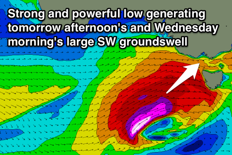
Tomorrow afternoon's and Wednesday's swell has been upgraded significantly, with a secondary frontal system that was expected to move in, in the wake of today's being upgraded in strength and intensity.
We're now looking at a fetch of severe-gale to storm-force W/SW winds being projected up and into us today and tomorrow, producing a large and powerful long-period SW groundswell.
This swell should kick solidly tomorrow from midday onwards, reaching 6ft+ across exposed breaks on the Surf Coast later in the day, with 8ft sets likely at Bells and Winki, while the Mornington Peninsula should pulse to 8-10ft near dark.
A peak in size is expected overnight ahead of a rapid drop through Wednesday from the 5-6ft+ and 8ft range respectively on the Surf Coast and Mornington Peninsula.
Winds tomorrow before the swell really kicks will be OK for protected spots on the Surf Coast but strong from the W/NW ahead of a shift to the W/SW through the day.
Wednesday will be the day to surf through as winds swing back to a moderate to fresh W/NW'ly (even NW at times) ahead of a weaker W/SW'ly through the mid-afternoon.
The easing trend will steady into Thursday as moderate amounts of reinforcing W/SW swell fill in, ahead of one final pulse of better SW groundswell Friday morning.
This should be produced by a polar front deepening into a polar low to our south-west tomorrow evening, producing a small fetch of severe-gale to storm-force W/SW winds through our window.
The size of this swell will be limited due to the low forming later in our swell window, being further away and the fetch being much smaller, but the Surf Coast should pulse back to 3-4ft+ Friday morning with 6ft to possibly 8ft sets on the Mornington Peninsula ahead of an easing trend during the day.
Winds look great with Thursday seeing N/NW tending SW winds, favouring the Surf Coast, while Friday will be good at more exposed breaks (although large in size) with a N/NE tending N'ly breeze (N'ly tending N/NW at times on the Surf Coast).
This weekend onwards (Nov 1 onwards)
We've got a couple of more healthy SW groundswell pulses on the cards from continued polar frontal activity being steered up towards us through the weekend. Winds for these pulses don't look as favourable as this week, but we'll review this again Wednesday.
Comments
Cape Sorell has kicked in a big way.. www.bom.gov.au/products/IDT65014.shtml
Be very solid this afternoon in Victoria but winds will spoil the party.
Wowz 8m @ 14 now
Wowz 9m @ 17 sec at cape sorrel . Sheepdog have u been surfin today ?
Will this swell make it all the way to fiji & isei at cloudbreaks
Haha camel is this your version of staying up to watch the ashes? Frothing!
Banks are fucked atm down my way caml...... My setup is similar to Clifton, but more open to se swell, a little less open to sw swell, and west or wsw aren't the best.... Was about 2 to 3 foot, but just shorebangers..... A boogyboarder would've had fun.... But a waste of time for an old codger.....
Camel, not the same swell, but same storm system.
So this large swell for Vicco and Tas was generated by this low here..
But you can see most of the fetch and swell is going to be blocked by Tas.
Cloudbreak will get the swell from the low as it pushed east of Tasmania and into the Tasman Sea last night..
The swell from the low as it pushed into the Tasman Sea will build strongly this afternoon in Sydney and peak in Fiji on Saturday.
Even longer period stuff arriving at CB on Monday. Not bad for November!!!!
Yeah Don, that's from a polar low that's firing up further south in latitude than the last system, during today..
Someone who visits this site regularly will be there..
My mate is flying in on Sat for a week.
Nice, gonna score some real nice waves!!
He wasn't wanting 'real nice' waves. He assumed November would be more playful waves!!!!
Haha, he's gonna be shitting himself when the bombs come through!
I think he's got restaurants in mind.
Surfline has given the first one 'purple blob of the week award'
http://instagram.com/p/utdqSTKZ82/?modal=true
Think Monday better longer period on active sea state.
Any reports from Vicco only got Sean Doherty dry docked on the button
Yeah, pumping 6ft+ Surf Coast.
Yeah mitch as a dedicated storm chaser i was on watch most of the night checking on the swells progress . Was most interested by tassies size then K.I. Size and esp lack of size . So checking cloudbreak forecast was just out of fantasy interest . A mate has been praying somthing comes his way in sydney so we've been talking about it together also .
Haha, well you can stream the 2nd test here http://live.extracover.pw/ while you wait the 26.6min in between buoy updates!
Yeah Cape du Couedic didn't show anywhere near as much size as the low formed later in its swell window and was more aimed into the Tassie West Coast. Still it got to 5-9m @ 15s overnight.
Also there would of been a lot of windswell contamination at Sorell with gusts of 58kts measured at 9:45am yesterday morning.
The surfline instagram re kevin has said what i was going to say about the storm / swell . Moving on from tas to fiji .
"Tasmania will get blasted by swell and gale force west wind on Wednesday, while breaks in southeast Australia will see a smaller, but still good size, portion of the swell on Wednesday with much lighter west wind."
Surf Coast was 6ft+ this morning and the best it's been in months. Bit better than a good size portion of the swell.
Anyways, yeah same storm but kinda two different swell events that would be hard to decipher just looking at the purple blob swell height charts.
Roga dat craig but not hard for me to decipher , I can see it ,and besides im good friends with huey we hang out and talk lots
Haha, you and me both. Sometimes he doesn't wan't to listen though and goes his own seperate way!
Yeah your middle name is huey craig . So how big will sat morn be at CB ? Compared with the recent big swell there ?
I'd say 8-10ft Camel, real nice!
Wow that's way above what your model is forecasting?
Yeah, it doesn't forecast these long-range swells very well. Size is always bigger than forecast. Gets the real big swells nicely, but the small-moderate pulses need to be boosted.
I'd be thinking 6-8ft with 10ft bombs.
Hmmm that's odd cause your model outputs nailed it for where I was in Indo and it doesn't get much more long range than that and they weren't big swells either.
This is only for Cloudbreak I should say.
Great for other locations around the world, but Cloudbreak seems to be some crazy swell magnet!
Also, that's great to hear!
Craig Huey Brokensha haha love it.
Haha, well seeing as I don't have a middle name...
What..! No middle name..?
Not Grandads.
Not your Dads..?
Nup, but my younger brothers both got them, weird ay!
All this time I thought your middle name was ' bro ' ...
And that you'd just rolled it into one !
Craig Bro Kensha.w
Hiding your real identity -: Ken Bradshaw ..... ;-))
Surfin the net a 2 in the morning southey. a life sadder than mine.
Get a surf? Went up to the circus coast masulf , very wonkey in the morning, sea-breeze came in mid morning, had a better surf at Rincon at high tide before the wind blew it right out, swell straightened up with bombs every 20 minutes, not bad 10 out , 3 surfing, no doubt wotd will make it look close to perfect, very rarely is. Looking forward to a summer of secret spots and magic moments after a very bad winter.
nah shaun ,
had just finished working and didn't realise the time ...
besides i can post then without fear of response !....?
Friday not looking as good now , i reckon i might be wandering down your way next week .
Yeah, well fuck off, no waves in gippsland.
You can feel more important posting in the middle of night
What a Rather Epic Week. Just woke up and surfed it rather than check this very valuable post, cheers in absentium Craig! More size (and wind) on the way...
Hey Sheepdog, from where I think you are, would a certain point named in favour of a dirty black substance, far away over an inland sea from you - had any goods when the big ones rolled through? Seen it a few times beginning to break and thought it might be a great setup on the day.