Average week besides Thursday morning, good Saturday

Victoria Forecast by Craig Brokensha (issued Monday 13th October)
Best Days: Thursday morning, Saturday, Sunday morning
Recap
Saturday was small, clean and fun across the Surf Coast through the morning while into Sunday a new long-range SW groundswell started to fill in with clean 3-4ft waves on the Surf Coast and 6ft sets across the Mornington Peninsula.
Winds held offshore until around midday, when sea breezes helped along with a shallow change moved through creating bumpy conditions into the late afternoon as the swell continued to slowly climb.
This morning the swell has held up in the large range with 4-6ft waves across the Surf Coast and larger choppier surf on the Mornington Peninsula with good conditions around Torquay early with a W'ly breeze before a stronger S'ly change moved through mid-morning. This has written off the surf for the rest of the day and will continue to do so into the coming days.
 This week (Oct 13 - 17)
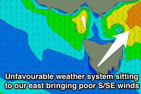
As touched on above, this morning's S'ly change is related to a deepening surface trough moving across us and we'll see this system stall off the East Coast and continue to strengthen over the coming days driving a persistent onshore breeze into us. Tomorrow this will be from the S/SE with easing levels of SW groundswell from today, and then a weaker S/SW'ly through Wednesday.
Thursday morning should see a new long-range SW groundswell from the polar shelf (south of WA) fill in with inconsistent 3ft waves across most of the Surf Coast with 4ft sets at swell magnets and 6ft+ surf on the Mornington Peninsula. Winds are due to be offshore for a short period through the morning on the Surf Coast from the W/NW ahead of another trough and gusty S/SW change through the day.
This trough is then expected to keep average E/SE winds blowing across the coast into Friday as the swell slowly eases, although the Mornington Peninsula may see periods of early E'ly winds.
This weekend onwards (Oct 18 onwards)
The weekend is looking much better for a wave as a reinforcing SW groundswell due Friday evening from weak but broad polar frontal activity under the country mid-week eases under offshore N'ly winds that should tend N/NW on the Surf Coast and N/NE on the Mornington Peninsula. The Surf Coast should offer 3ft sets through the morning ahead of a drop through the day, with 5-6ft waves on the Mornington Peninsula.
Sunday will be smaller and a little dicier with early light N/NW winds likely to give way to another S'ly change as a weak trough moves through. Therefore Saturday will be the day to surf with a small window Sunday morning.
Longer term the trough moving through Sunday is expected to linger and then be replaced by a slow moving high pressure ridge resulting in poor SE winds and small to moderate amounts of swell. We'll look at this in more detail on Wednesday though.