Fun end to the week, large swell building Sunday with dicey winds

Victoria Forecast by Craig Brokensha (issued Wednesday 8th October)
Best Days: Thursday Surf Coast, Friday both coasts, Saturday morning for keen surfers Surf Coast, Sunday morning both coasts
Recap
Yesterday started off average with a small bumpy 2ft of swell on the Surf Coast and larger messier waves to the east. A close-range increase in W/SW swell was seen through the day though to 3ft around Torquay and 3-4ft at 13th Beach as winds tended W/SW creating OK bumpy waves for keen surfers.
Today a stronger W/SW groundswell has filled in with good clean 3ft waves across the Surf Coast while the Mornington Peninsula is larger and in the 6ft range but poor with the W/NW breeze.
This week (Oct 9 - 10)
Today's lift in moderate sized W/SW groundswell should be reinforced by a secondary pulse through tomorrow, keeping the Surf Coast ticking in the 3ft range with 6ft sets on the Mornington Peninsula. These swells have been generated by a couple of strong mid-latitude fronts pushing in under the country the last day or so, and one more is now dipping south-east from the Bight, generating a smaller W/SW swell for Friday.
This swell is expected to offer much size above 2-3ft Friday morning on the Surf Coast and 5-6ft on the Mornington Peninsula before easing through the day.
Now, winds tomorrow will be great for the Surf Coast and offshore from the NW (possibly N/NW on the Mornington Peninsula) before weak onshores develop through the mid-late afternoon. Friday looks great across both coasts with light local offshores and ahead of weak SW breezes into the mid-late afternoon again.
This weekend onwards (Oct 11 onwards)
Saturday will become a low point in activity with smaller but clean leftover waves on the Surf Coast with a morning offshore W/NW breeze.
 Now, the large SW groundswell event due Sunday and Monday is still on track, but winds are moving all over the shop because the models are struggling to resolve a surface trough moving in from the west over the weekend.
The system does look to stall a little to our west now which would result in N'ly winds through Sunday morning (even NE if it stalls as long as GFS was indicating this morning) but I feel we'll see a fresh W/SW change move through the day/afternoon at some stage with poor S/SW winds then due into Monday.
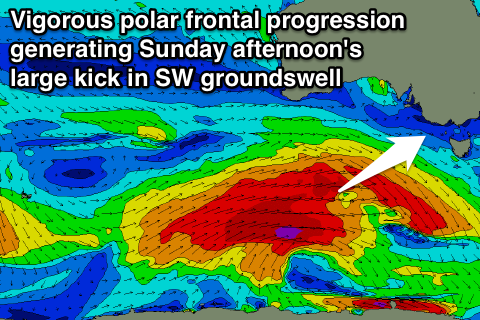
Coming back to the swell though, a strong node (peak) of the Long Wave Trough moving through later this week will steer a couple of vigorous polar fronts through our south-western swell window through the coming days and into the start of the weekend.
A large SW groundswell should result, building through Sunday, peaking overnight before easing into Monday as large levels of SW windswell fill in.
Size wise we should see the Surf Coast build from 3-4ft Sunday morning to 4-6ft later in the day, but by this time winds are likely to have gone onshore. The Mornington Peninsula should build to 8ft+ and then ease through Monday.
This will all have to be reviewed on Friday though when the models should come fully into alignment, but in the meantime keep an eye on the 6 hourly forecast updates on the site for an idea on which way the models are tending and when the onshore change will hit.
Comments
Is it too much to ask just to have a 8ft swell with light north east winds?!?
Just one!!
That touch of westerly in it is a killer. Praying Sunday is n.e
It's definitely a chance, if GFS gets its way it'll be NE Sunday and E/NE Monday..
Bit too hard to pick at this stage though.
Cheers Craig. It's so frustrating down here that we get so much swell but about 80 % of the time the winds are wrong.
Fingers crossed haha
Thanks craig . Now i can dream of another place to surf
Lets give it another day or so when the models hopefully line up and then I'll flick you a message.
Have you surfed in Victoria much camel?
Yeah that'd kill me, such a waste.
Latest update has wind fresh nth ? GF not much but am keen
Yeah it does, strengthening N/NE tending N'ly, holding most of the day as well. Opens up a lot more options but it will be a race between the swell building and the change hitting.
I wouldn't be putting any investment in Access G being accurate .. It has the surface low dancing all over the shop . The Upper low's inception / stall and deepening time will define the surface . Either way i would hazard a guess that winds would be on the lighter scale .
Yeah, another day closer to the event it looks like we're going to see some form of weak N'ly breeze Sunday morning with weak onshores into the afternoon before the trough/low moves in through Monday.
bugger, early monday or arvo?
Depends where you're talking Mick? And still lots of movement around this funky system, it will have a mind of its own and stall when it wants to stall and push east bringing onshores when it so pleases as well.
Hey Craig, is this swell likely to peak Monday morning or Monday night on the West Coast? Swellnet suggests Monday morning but Willyweather seems to be saying Monday night/Tuesday?
Hi Will, this will take a bit to explain so try stay with me.
So the large long-period and strong SW groundswell is due to peak Sunday afternoon across the Vicco West Coast, and you can see that spike and plateau in the size on the forecast graph.
Here's the storm generating the swell along the polar shelf..
And peak on the graph Sunday arvo/evening..

Now, the tricky low I've been talking about in the notes above looks to be quite strong and it'll produce an additional large stormy swell once it pushes into the coast and this looks to be Monday.
Here is the low approaching from the south-west (right off the Vicco Coast)..
This is what is producing that secondary pulse on Monday, but the periods and size will be all mixed and poor. Still large but quite stormy.
Models are still moving around the peak in size from this low as they are struggling to pick when it will move in and hit the Vicco coast.
So in summary, 1st pulse of strong long-period SW groundswell Sunday, peaking through the afternoon/evening.
2nd pulse of junky stormy close-range W/SW-SW swell for Monday, peaking sometime through the day depending on low movement.
Great thanks Craig, I'll keep watching as it progresses
Seems like the latest wind forecasts are in favour of surfers . Sunday arvo potential for some solid waves ?
Yeah it'll be nice and clean Sunday morning, but the swell isn't really due to kick until the afternoon and a weak change/sea breeze might be in by then. Updating the forecast now.
not sure which wind forecast / synoptics your looking at Camel .
But on the latest charts I've looked at ( neither of which is on this site ) , i wouldn't bother trying to surf west of Torquay on Sunday .
The secondary system looks to fill in quicker ( subject to change ) , which will mess up the swell at exposed spots . So unless you want to target certain beachies that will see the swell after it refracts ( which will clean it up ) then for now i wouldn't " fill the tank with petrol " .....
But as Craig has said all along this system will be one to watch as it does have potential to line up well . Just watch every chart update from the models .
21 & 20 sec registering along w.a. Coast this morn
Yeah, that's got no major size to it, long-range and inconsistent SW groundswell from the south-east of South Africa.
Bigger stuff from south-west of WA is due into tomorrow.
Yeah southey that pesky low moves in quicker than u wish hey ?
Roga that craig . Thats probly true super small & inco for now but a warning not to dive for lobsters
21 sec runners arrived while i was surfing an hr ago it seemed like it went from 2 ft to 4ft with great sets rumbling .... Awesome greeting cheers to forecasting
Haha, how good is that Camel! Love being in the water when you can actually see/feel and surf a building or new swell.
although insignificant to what u guys experience. I remember being on one cairns beach, flat, then swoosh, it grew to three foot, dirty brown and full of debri. I had an an al byrne channel bottom pin tail, lost back fin first wave hitting log/telegraph pole. Had whole family on beach, no bottom turn turn possible, got chased in by big croc- wannabee singing loud, self worth of the rave minimum.
Meanwhile a massive swell approaches the southern part of our island
Not quite so massive p. eak period isnt as big as hoped
Although now theres been a swell rise on c s buoy 5 @ 16
Tassie was always going to be the best option to surf yesterday , today and tomorrow.
Yeah southey ! Somewhere far from tassie was going off just 2 ppl
Under the radar . Cant wait to see film of shippy tho