Fun weekend, Surf Coast from Monday arvo

Victoria Forecast by Craig Brokensha (issued Friday 26th September)
Best Days: Saturday across both coasts (afternoon east of Melbourne), Sunday morning, Monday afternoon on the Surf Coast, every morning from Tuesday around Torquay
Recap
I hope you didn't plan to surf yesterday as it was poor as expected with a small swell and onshore winds from the S/SW-SW.
Today is the complete opposite with a strong but inconsistent W/SW groundswell filling in under offshore W/NW winds coming in at 3ft around Torquay, a bumpy 3-4ft at 13th Beach and average 4-6ft on the Mornington Peninsula.
The swell should peak this afternoon to 3ft+ across most breaks west of Melbourne with those 4ft sets at swell magnets and 6ft+ on the Mornington Peninsula, but winds have already gone light and variable, with weaker SW winds due into this afternoon.
This weekend (Sep 27 - 28)
Today's good increase in long-range W/SW groundswell should peak this afternoon and ease off slowly through tomorrow across both coasts. The Surf Coast should still offer 3ft sets with 5-6ft waves on the Mornington Peninsula.
Conditions are looking great for both coasts at stages during the day with an offshore N/NW breeze during the morning expected to tend variable and even possibly NE on the Mornington Peninsula into the afternoon, creating a full fun day of waves if you're not interested in the Grand Final.
Sunday morning will be small but fun with easing 2ft waves on the Surf Coast and 3-4ft+ on the Mornington Peninsula under strong and warm N'ly tending N/NW winds.
Next week onwards (Sep 29 onwards)
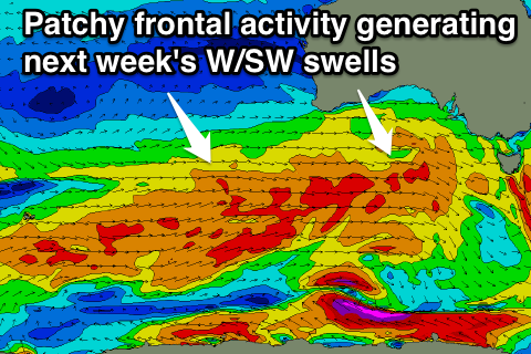
As indicated the last few updates, the outlook into next week is much more active as a strong node (peak) of the Long Wave Trough moves through the Bight Sunday and then across us through Tuesday.
This will steer a flurry of frontal activity through our western swell window, but the only issue is that each front will be quite patchy in nature with winds in the gale-force range (down from the forecast severe-gale range earlier in the week).
This will result in medium to possibly large levels of W/SW swell (biggest through Wednesday).
Initially a moderate sized increase in acute W'ly swell is due through Monday, building all day ahead of a peak through the afternoon. This will be generated by a first cold front pushing through the Bight, with the the Surf Coast expected to reach 3ft in Torquay through the afternoon (smaller earlier) with the Mornington Peninsula pulsing to 6ft+. Fresh and gusty but easing NW tending W/NW winds will create clean conditions all day west of Melbourne. So aim for an arvo paddle rather than the morning.
 A secondary better aligned pulse of W/SW groundswell is due through Tuesday from a secondary polar front projecting a fetch of W/SW gales towards us a more southern latitude through Monday before pushing up into us Tuesday afternoon.
This should see the Surf Coast building from 3ft Tuesday morning with 4ft sets showing through the afternoon as fresh morning offshore NW winds swing W/SW into the afternoon.
Wednesday should offer the most size as the W/SW swell peaks to 4-5ft on the Surf Coast and 6-8ft+ on the Mornington Peninsula during the morning under fresh W/NW tending W/SW winds.
From here on the frontal activity will slowly subside with a drop in size due into Thursday and Friday under a generaly W/NW to SW flow on the Surf Coast and W'ly to SW breeze further east.
Longer term there's nothing major on the cards into the weekend, but we'll look at this again Monday. Have a great weekend and go the Hawks!