Average until Friday

Victoria Forecast by Craig Brokensha (issued Monday 11th August)
Best Days: Friday, Saturday morning, Sunday morning east of Melbourne
Recap
Friday's kick in fun S/SW groundswell eased back slowly from 2-3ft Saturday morning on the Surf Coast and the 4ft range on the Mornington Peninsula. Conditions were great across both coasts most of the day with N-NW winds west of Melbourne and persistent offshore N'ly winds to the east.
Into Sunday morning the swell bottomed out, but the Surf Coast saw clean small 2ft waves at dawn before a strong W/SW change moved through soon after. This wrote off the surf for the rest of the day as a large and powerful SW groundswell filled in.
This swell has held into today but fresh S'ly winds have left only a selected few locations with decent waves.
This week and weekend (Aug 12 - 17)
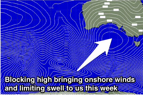
Unfortunately poor surf due to onshore winds will continue over the coming days, owing to a slow moving high pressure ridge pushing in from the west.
 We'll fall under a weakening southerly pressure gradient with a dropping swell and moderate to fresh S'ly winds due through tomorrow before easing back into Wednesday and Thursday to the moderate range.
There's a very small chance for early W'ly winds around Torquay Wednesday morning and Thursday morning, but it's not worth the drive from Melbourne.
The swell should bottom out Wednesday morning but a new SW groundswell is due into the afternoon and Thursday. This will be generated by a small but strong polar front skirting around the strong, slow moving high to our west. An inconsistent 3ft+ wave is due across the Surf Coast Thursday with 5-6ft waves on the Mornington Peninsula.
A secondary pulse from a broader but less favourably aligned polar front skirting around the high should keep 3ft and 4-6ft waves hitting both coasts respectively into Friday morning before easing through the day and into Saturday and Sunday.
Winds will finally swing offshore Friday morning, so this will be the day to make the most of, with a light local land breeze expected across most of the state ahead of weak onshore winds into the afternoon.
Into the weekend variable winds on Saturday morning should continued to create clean but possibly lumpy waves across both coasts, with E/NE winds into Sunday.
Looking ahead into next week and unfortunately there's nothing significant on the cards at all as an upper level blocking pattern setups across our medium-short range swell windows. Check back here on Wednesday for any change to the situation though.