Tricky period with no major swell until mid next week

Victoria Forecast by Craig Brokensha (issued Wednesday 2nd Jul)
Best Days: Thursday, Friday keen surfers around Torquay, Monday east of Melbourne.
Recap
A good pulse of medium sized W/SW groundswell filled in yesterday and this provided fun 3ft waves across the Surf Coast under W/NW winds, while the Mornington Peninsula remained average and bumpy.
Today the swell has held in at a similar size under more favourable NW winds across the Surf Coast and 5-6ft bumpy surf on the Mornington Peninsula. The swell should drop slowly through today as winds persist from the W/NW.
Thursday through the weekend (Jul 3 – Jul 6)
Today's swell will be replaced by a long-range and inconsistent W/SW groundswell tomorrow, and although the forecast model has 2-3ft waves persisting on the Surf Coast tomorrow I fell the swell will fall back to the smaller 2ft+ range.
The Mornington Peninsula should offer good 3-5ft waves and with winds swinging more N'ly through the afternoon after a morning N/NW'ly.
Friday will be smaller but clean on the Surf Coast with fresh to strong N/NW winds ahead of an approaching mid-latitude low.
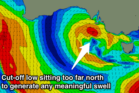
The models were unclear on what form this low would take on Monday, and I edged towards the European and Australian forecasts and these seem to have come to fruition with a front pushing east from over WA expected to take the form of a cut-off low, which will severely limit the swell potential across our coasts.
 I believe the models are over-forecasting the swell for Saturday, combining a small long-range and inconsistent W/SW groundswell from the Indian Ocean with the short-range swell as the low moves through Bass Strait.
In all likelihood the Surf Coast isn't due to get above 2ft, with 3-5ft sets on the Mornington Peninsula but with NW tending fresh to strong S/SW winds.
Come Sunday the swells are expected to ease with onshore SW winds across most spots besides Torquay which should see an early W'ly.
Next Monday onwards (Jul 7 onwards)
Next week will start slow with small and inconsistent levels of background W/SW groundswell from the Southern Indian Ocean under N-N/NW winds both Monday and Tuesday.
But as talked about last update, a strong node of the Long Wave Trough is forecast to move in from WA Sunday evening, over towards us through the middle of next week.
Initially a vigorous polar front will be projected up towards WA under the influence of the LWT, generating at least a medium sized W/SW groundswell for us, arriving Wednesday afternoon and peaking Thursday morning.
Behind this though we may see a secondary stronger frontal system deepening off our doorstep, generating a large swell for Friday/Saturday. This is still undecided, so we'll have to review the outlook again on Friday.