Another great run of swell ahead, though windy at times

Sydney Hunter Illawarra Surf Forecast by Ben Matson (issued Fri 25th April)
Features of the Forecast (tl;dr)
- Fun leftover E swell Sat & early Sun with generally OK winds
- Building E/NE tending E'ly swell Sun PM but with potentially dicey winds
- Solid swells from the E, SE and S on Monday but windy from the south
- Smaller, cleaner leftovers on Tues
- Very large and windy conditions developing Wed, easing Thurs
- Plenty of swell into next weekend too
Recap
Onshore winds maintained lumpy conditions through Thursday however the east swell held strong with size around 3-4ft. A slight easing of size has occurred today with cleaner conditions thanks to lighter winds, size has been around the 3ft mark form the east.
This weekend (Apr 26-27)
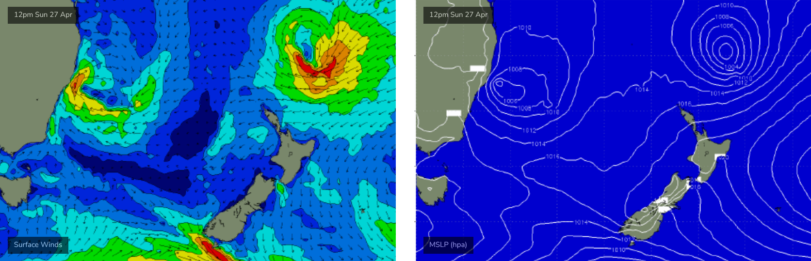
The synoptics are looking quite complex across the Tasman Sea, but the good news is that we’ve got plenty of waves on the way.
An undercurrently of E’ly swell should maintain 2-3ft sets across most beaches on Saturday. Winds will be mainly out of the N/NE however we should see local patches of early light NW winds, creating reasonably clean conditions. The afternoon breeze won’t become too strong though it will take the sheen off things.
By Sunday, a trough of low pressure currently off the Far North Coast will have drifted south (through Saturday), and is expected to form a closed low off the Sydney coast during the morning.
Now, the models are confident that this solution will happen, however there is some disagreement as to exactly where the low will develop - it’s a latitudinal distance of perhaps a couple of hundred kilometers - but this will mean all the difference between blown out mush, and potentially quite fun waves.
Current thinking is that we’ll see early light variable winds slowly freshen through the morning, as they tend NE and then swing from the E to the SE before strengthening S’ly into the afternoon. But, there is a chance that this pattern may be delayed until Monday (or at least, initially confined to the Hunter region).
As for surf, we’ll see lingering background E’ly swell in the 2-3ft range early, but a new short range E/NE tending E’ly swell will then build through the afternoon, with size dependent on how the low evolves, but 4-6ft sets are not out of the question by the end of the day.
Of course, the more optimistic size projections are also likely to be accompanied by less favourable winds. But even if the wind does pick up, we should see options open up as it veers counter clockwise.
Either way, it’ll be well worth keeping your eyes peeled for windows of opportunities both days.
Next week (Apr 28 onwards)
Sunday’s developing low off the coast will contribute plenty of size and (probably) wind on Monday. Swell will consist of a mix of energies from the east, some stronger SE energy from the southern flank of the low and possibly some new short period southerly swell, though the fetch length will be short in this regard. Combined surf size could be up to 5-6ft at exposed spots (some models suggest more, but they're still divergent across the board, so I'm being cautious).
In any case, this sounds like a complex, disjointed day of surf best suited to the beachbreaks except winds will likely be fresh southerly, relegating surfable options to southern corners.
The Tasman Low will quickly ease through Monday so smaller surf is then expected through Tuesday (easing from 3-4ft to 2-3ft), including some background E/NE energy generated by a broad fetch atop a large high east of New Zealand (right now).
The head of this fetch will be enhanced over the weekend by a small tropical low drifting south from a position south-east of New Caledonia, that will briefly display impressive wind strengths (see below) - however the large travel distance means surf potential will be around 3-4ft from this source mid-late week. It’ll also be overshadowed by a local weather system pushing up the South Coast on Tuesday.
This next system will be in the form of a sharp trough, which will initially provide a subtle increase in S/SW breezes through Tuesday, before it kicks in properly on Wednesday with gale force winds across most locations, persisting into Thursday though gradually easing.
An associated local swell will increase rapidly on Wednesday with size likely to push north of 8ft+ by the afternoon, easing into Thursday as local winds throttle back. We'll have a better idea on specifics on Monday, right now is too early to have much confidence.
There’s also a suggestion that the broadscale pattern associated with this system may linger across Tasman longitudes into the end of the week, which could maintain smaller but still-strong surf from the SE into next weekend.
It’s certainly been an Autumn to remember.
See you Monday!
Comments
Another great report, thanks.
Kids back at school Monday, hopefully mums and dads back at work.
I could get a surf at my local. What?
Public schools don't have students till wednesday.
https://education.nsw.gov.au/schooling/calendars/2025