Plenty of swell, just gotta work around the winds

Sydney Hunter Illawarra Surf Forecast by Ben Matson (issued Fri Mar 15th)
Features of the Forecast (tl;dr)
- Easing, improving surf on Sat as winds become lighter and gradually swing to the NE
- Strong S/SE groundswell building Sun (peaking late) with light/mod NE winds freshening
- Easing S/SE groundswell Mon with light/mod NE winds
- Mix of swells Tues with freshening NE winds
- Potential fun window of E/NE and NE swells Wed with a brief W'ly period before gusty S'lies kick in
- Plenty of swell for the long term
Recap
Easing S’ly swell from 4ft+ on Thursday has levelled out at 3-4ft today with some new SE and E’ly swell in the mix. Light winds and clean conditions Thursday morning gave way to a fresh southerly change mid-afternoon, which has maintained strength today as the direction has gone S/SE.
This weekend (Mar 16 - 17)
Today’s onshore pattern will contract to the North Coast on Saturday, so apart from the Hunter (which may see a lingering breeze in the morning), local conditions should be clean under generally light onshore tending variable winds. We’ll see a late swing to the NE though this will become more prominent on Sunday.
Surf wise, we’ll see a mix of trains from the S and SE, plus some easing trade swell from the E/NE. South swell magnets may see the odd 3-4ft set early though it’ll ease to 2-3ft through the day, and beaches not open to the south will be smaller in size.
Sunday looks very interesting with a new long period S/SE groundswell expected to build through the day. Sourced from an unusual polar low off the ice shelf during the middle of the week, we’ll see initially undersized waves early morning (delayed a little longer north from Sydney too) climb from late morning/luhnchtime onwards, reaching a late peak in the 4-5ft+ range at south swell magnets, potentially bigger waves 6ft+ bombs at offshore bombies and along the Newy stretch, right on dark.
Of course, beaches not open to the south will be much smaller in size.
Local winds won’t be terribly strong but the NE direction and strong surf will rule out many locations after lunch, so it’ll be worth seeing what the morning’s lighter, more variable period has on offer at exposed beaches.
Next week (Mar 18 onwards)
Sunday’s late surge in south swell will persist overnight into early Monday but trend down steadily through the day. Expect 4-5ft+ sets at south facing beaches at dawn (bigger swell magnets and across New) but much smaller elsewhere, easing by at least a couple of feet throughout the day.
A similar wind regime as per Sunday will have a touch more strength so it’ll be worth scouting out the same locations you capitalise in on the second half of the weekend.
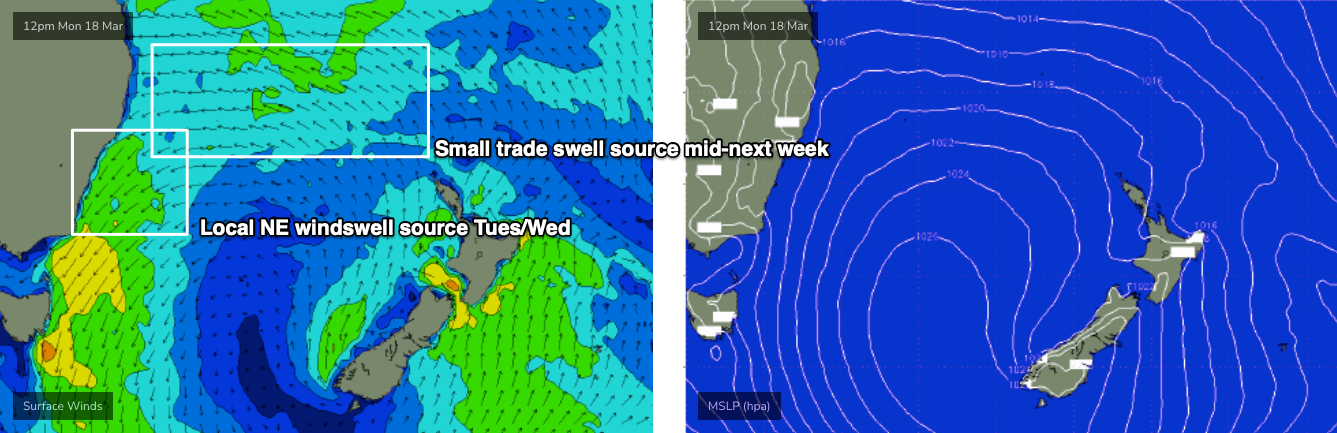
Building trade swells are expected on Tuesday thanks to a robust Tasman high that will concurrently freshen NE winds about the coast, so conditions won’t be great - though we should see sets around the 3ft mark, perhaps a little bigger into the afternoon at reliable swell NE magnets.
Wednesday has a fresh southerly change pushing up the coast, and we could see a window of very good waves just before it arrives. Tuesday's overnight N/NE winds adjacent the coast are likely to generate punchy windswell (on top of a decent underlying trade swell) with sets around 3-4ft and it looks like there’ll be a window of W’ly winds at some point throughout day.. we’ll firm up on Monday.
Looking further ahead and a persistent pattern of trade swells will maintain fun waves across most beaches for the following week or so, whilst a series of short range southerly swells (trailing their parent S’ly changes) will provide solid though somewhat wind affected bouts of south swell - at this stage Thursday and again on Saturday.
Have a great weekend!
Comments
Thanks Ben - always love ur notes and get better waves than I otherwise would coz of em - THX
Surf might be shit today but just watched a sail boat almost get washed onto Shark Island on the surf cam : 2:33pm when the replay comes up. I was torn between hoping they'd get washed up and hoping they'd be ok ... could have gone either way.
Or, they were just tying to pull-in.
Any idea as to what happened to the Maria island buoy?
S/SE groundswell came in nicely yesterday arvo on the lower MNC. 4-5ft generally but some chunky 6ft cleanups across the magnets,
It was missing the cen coast a bit. Had fun waves 3-4ft on a south facing beachie, but was hoping for some more action on the reefs and points.
Was 2-3ft on the NB all arvo yesterday but definitely felt the period kick after 3pm!
Agh, not as big as expected locally then. I was at a magnet up north.