But wait, there's more! (from the Tasman Low)

Sydney Hunter Illawarra Surf Forecast by Ben Matson (issued Fri 16th Dec)
Forecast Summary (tl;dr)
- Large S'ly swells and fresh S'ly winds Sat, easing a little into Sun
- Renewal of strong S/SE swell on Mon with continuing S'ly winds
- Gradual easing of swell and wind for the rest of the week
- Developing N/NE winds late Thurs/Fri
Recap
Small levels of building E/NE swell on Thursday morning coincided with a few hours of W/SW winds ahead of gusty southerlies that developed mid-morning, and have held into today. A rapid increase in south swell reached 8ft+ late Thursday afternoon, and although wave heights have eased back a little this morning to 6ft+, the swell is still very strong across exposed south facing locations under fresh to strong southerly winds. Other beaches are seeing a smaller combination of energy including building E/NE swells that's now around the 4ft mark, though sets are very inconsistent.
This weekend (Dec 17 - 18)
Looks like we're in for a very slow easing of local winds and surf size over the weekend.
Although wave heights have slowly abated since yesterday afternoon's impressive peak, we're still within close proximity to a dynamic system and there's every chance we could see a renewal of stronger energy later today and into Saturday morning.
Therefore, despite an expectation that the weekend size will trend one way, it's difficult to have confidence in the starting figure: will surf size continue to abate from now into tomorrow - say, 4-5ft - and then continue downwards into the weekend, or will we see a size reset back up into the 6-8ft range within the next twelve hours?
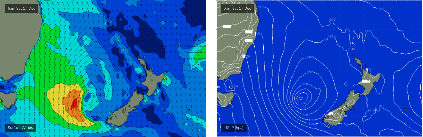
The current synoptic charts suggest the latter scenario, with southerly gales very active east of Tasmania up into the lower south-western Tasman Sea from last night into this morning. So, with a travel time of half to one day, we should see an uptick in energy over the coming hours, with strong energy persisting into Saturday morning.
Let's peg the sets around 6ft+ at south facing beaches (bigger across the Hunter and at offshore bombies), with smaller surf elsewhere from both the south swell and a peak in the E/NE energy, around 4ft+.
By Sunday we'll be back to 4-5ft at south facing beaches (still some bigger sets across the Hunter), and remaining beaches will see a smaller combo of surf in the 2-3ft range. Size will come down another foot or so throughout the day.
Both days look wobbly with moderate to fresh southerlies, though early mornings should see pockets of SW winds; initially limited to a few locations like the Northern Beaches (Saturday), extending to a few more regions on Sunday as the broader synoptic flow eases back a touch more.
So, plenty of waves though protected spots will be best.
Next week (Dec 19 onwards)
A reintensification of the Tasman Low on Saturday and Sunday - further east, near New Zealand (see below) - will generate a renewal of strong S/SE thru SE swell for Monday, with size rebuilding during the day, reaching 5-6ft at most exposed beaches, even pushing 6ft to maybe 8ft across offshore bombies and reliable swell magnets (expect much smaller surf at protected southern ends).
This swell is expected to peak in the afternoon.
We'll still be under a moderate to fresh southerly breeze at this point but early morning should offer a period of lighter SW winds across the region.
Wave heights will then ease slowly through the rest of the week (3-5ft Tues, 3-4ft Wed, 2-3ft Thurs, 2ft Fri), with winds becoming light and variable ahead of freshening N/NE winds from late Thursday through Friday. Most open beaches should offer great waves throughout this period. We'll see peaky NE windswells on Friday with average conditions at most open beaches.
The Xmas period looks small on the charts right now but there's a few signs that we'll see increasing tropical activity that could lead to some interesting developments - though models are quite divergent so there's no use speculating too much right now. Either way, it'll be very interesting to assess the model guidance on Monday.
Have a great weekend!
Comments
Definitely felt like it was getting bigger - still rubbish at Maroubra but bigger
That new pulse of swell has kicked, back to 6-8ft on the beaches.
Some cracka barrels this arvo
Youre were right Craig some really nice bombs this morning enough to snap my stepup.
Dropping quickly now though
What a run and there's still a ton more to come. Incredible run of S-SE swell for December.
Yes thats talk in the water never ending south swell which suits my area perfectly.
Yahoooo