Strong from the south for a few days; long range looks good from the east

Sydney Hunter Illawarra Surf Forecast by Ben Matson (issued Wed 7th Dec)
Forecast Summary (tl;dr)
- Temp easing S'ly swell Thurs with brief window of offshore winds (more so from Sydney north)
- Gusty S'ly change kicking in by mid-morning, building S'ly swell into the a'noon
- Strong secondary S'ly swell building Fri
- Large S'ly swell peaking overnight & holding thru' most of Sat with better (lighter) winds
- Steadily easing size Sun with light morning winds
- Fun small NE windswell Mon with offshore winds
- Strong E/NE groundswell due late next week/weekend
Recap
Leftover E/NE swell provided 2-3ft sets on Tuesday, with gusty southerlies generally ruining surf conditions away from protected southern ends (though, as expected there was a window of lighter winds at dawn). Today's seen the arrival of a stronger south swell in the 4-5ft range, and light winds have kept conditions clean through the morning though afternoon sea breezes have kicked in ahead of a developing W'ly change. So a late cleanup is looking likely.
This week (Dec 8 - 9)
No major changes to the forecast for the rest of the week, if anything an upgrade in size for the next south swell.
Our current south swell will throttle back overnight, leveling out into the 3ft range at south facing beaches for Thursday morning (much smaller elsewhere, though bigger across the Hunter) and it'll be nice and clean with a brief window of early offshore winds at dawn.
But it won't last long.
A gusty southerly change is due to push into the Illawarra close to, if not slightly before dawn, reaching Sydney an hour or two after sunrise, and this will create bumpy conditions everywhere except sheltered southern corners.
We'll see steadily building south swells in its wake, generated by a trailing fetch, but a new Tasman Low will concurrently develop off the South Coast and mnove slowly eastwards. The latest model runs have strengthened this low, broadened its fetch and slowed its eastwards track.
Which means bigger surf for Southern NSW.
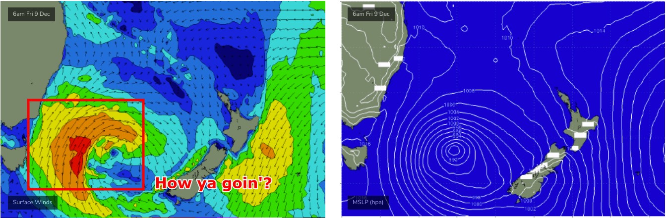
Thursday afternoon's building short range energy should reach a bumpy 4-5ft at south facing beaches by mid-late afternoon (6ft sets in the Hunter), before a temporary easing trend overnight into early Friday, ahead of a second, larger south swell sourced from the low, that will build through Friday afternoon and probably peak early Saturday morning.
Even better, Friday should see pockets of early SW winds as the S'ly flow gradually abates across the region. Sure, this will coincide with a temporary (relative) low point in size but the breeze should remain light all day even once it swings back onshore, so the day's building trend should be workable at a wide range of spots that can handle the size.
Late sets should be pushing 5-6ft at south facing beaches, up to 6-8ft at some of the more reliable deep water reefs and regional swell magnets like the Hunter. Of course, locations not open to the south will be much smaller. And as the swell will be coming from the south, we'll see an earlier arrival in the south, and a later arrival in the north - i.e. Hunter - which means the further north you are, the more chance there is that it might just push through a little too late to benefit from the bigger energy.
So, keep some flexibility in your expectations for Friday's size but there should be some strong surf on offer, particularly through the afternoon.
This weekend (Dec 10 - 11)
Friday's late strong surf should hold through most of Saturday - model guidance doesn't really have the low weakening (east of Tasmania) until the early hours of Saturday, and there's a day's travel time or thereabouts from the source, so expect punchy surf for the most part.
I'll peg size around 5-6ft at south facing beaches (expect bigger 6-8ft bombs at the regional swell magnets) but smaller waves elsewhere due to the direction. Conditions look very good with light variable winds and sea breezes. A late easing trend is possible.
Steadily easing size on Sunday will be accompanied by an early light offshore wind ahead of freshening NE breezes into the afternoon. South facing beaches should see early 4ft sets, down to 2-3ft by the afternoon and it'll start to become very small at sheltered spots.
Next week (Dec 12 onwards)
Sunday's late freshening NE winds should generate some fun peaky waves for the start of the new week, and with another approaching low from the west, we'll see early W/NW winds veer W/SW through the day, creating clean conditions.
It won't be terribly big but exposed spots should manage early 2-3ft sets, easing into the afternoon.
A series of small funky south swells are then ex[ected through the middle to latter part of next week, sourced from poorly aligned fronts and lows (generally tucked in behind the Tasmanian swell shadow), however the good news is that the long range models are suggesting a deepening tropical low near Fiji from this weekend onwards - plus a strong supporting ridge and associated trade flow to its south-east - that's expected to generate a cracking E/NE groundswell for the end of next week and the following weekend. Possibly up into the 4-6ft range, though it's early days right now and I'm feeling a little perky.
See you Friday!