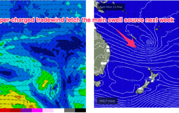
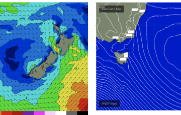
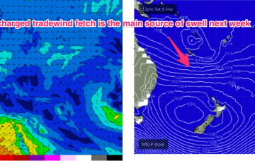
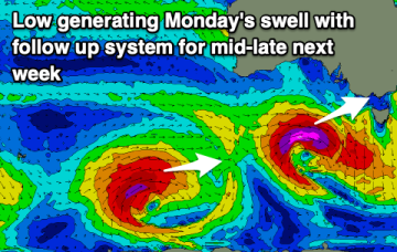
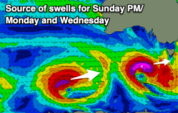
Building west swells over the period
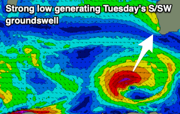
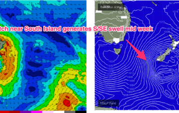
The current S/SE swell will fade into tomorrow with new levels of W/SW swell on the build with slightly tricky winds.
Make the most of the current swell and winds along with tomorrow morning. Following this the next good surf day looks to be early next week.
We currently have a weaker cell in the Tasman, with a much stronger cell entering the Bight. This dominant high pressure belt will set up a long, broad tradewind fetch through the Coral Sea, extending at times into the Northern Tasman and South Pacific.
N’lies then increase in the swell window over the weekend as high pressure drifts into the Tasman Sea bringing increasing NE windswell from Sat a'noon.
There should be fun options across both regions this period with fun swells from the west-southwest.
Classic late Summer pattern sets up this weekend with high pressure straddling New Zealand, a monsoon trough strung across Northern Australia extending into the South Pacific and a long, broad tradewind fetch between the two broadscale atmospheric features. The fetch is so broad and long and super-charged by low pressure embedded along the Northern Flank that we’ll see quite an energetic E’ly swell build over the weekend and extend into most of next week.
Classic late Summer pattern next week with high pressure straddling New Zealand, a monsoon trough strung across Northern Australia extending into the South Pacific and a long, broad tradewind fetch between the two broadscale atmospheric features. The fetch is so broad and long that we’ll see quite an energetic E/NE swell propagate down the NSW Coast.
A new swell will come in lumpy Friday, improving on the weekend with another good pulse for early next week.
We should see rideable surf develop through Wed as a SE surge builds across the region and extends out into the Coral Sea.
Current ASCAT (satellite windspeed) passes show a long fetch of severe gales in the southern swell window and wave buoys are all in an aggressive upwards curve as strong S swells propagate along the Southern NSW Coastline after making landfall in Tasmania.