Good swells to come with generally favourable winds

South Australian Forecast by Craig Brokensha (issued Wednesday March 6th)
Best Days: Later tomorrow Mid Coast, Friday morning both coasts, South Coast Saturday and Sunday morning, later Sunday Mid Coast, both coasts Monday
Features of the Forecast (tl;dr)
- Late increase in moderate sized W/SW swell tomorrow with E/SE-S/SE winds
- Peak in swell Fri AM with NE tending SE winds (E in the AM on the Mid)
- Easing swell Sat with N/NE tending fresher NW winds
- Late pulse of new W/SW swell Sun, peaking from the SW Mon AM
- Variable winds Sun Am ahead of sea breezes, local offshore Mon AM with weak sea breezes
Recap
Monday’s large pulse of S’ly groundswell (that looked to peak into the afternoon) eased back into yesterday as conditions improved down South with clean 3ft surf and options all over. This morning was smaller but clean again with light winds, but freshening S/SE winds are due through the day.
The Mid Coast was tiny yesterday and flat into today.
This week and weekend (Mar 7 - 10)
Tomorrow will start small to tiny, but later into the afternoon and evening some new mid-period W/SW swell energy should be seen, with a peak due Friday morning.
The swell was generated by a distant but good fetch of strong to gale-force W’ly winds to the south-west of Western Australia on the weekend and earlier this week. The frontal progression has since weakened and is passing under the country, bringing today’s freshening S’ly winds.
The Mid Coast is likely to kick to 1-1.5ft by close of play tomorrow, peaking Friday to 1-2ft, though inconsistent. Middleton looks to come in at 3-4ft.
In the wake of the trough, winds will shift E/SE-S/SE tomorrow ahead of sea breezes, with Friday seeing local offshore winds ahead of sea breezes.
Saturday looks great across the South Coast with freshening N/NE tending NW winds and easing 3ft sets, bumpy and tiny on the Mid Coast.
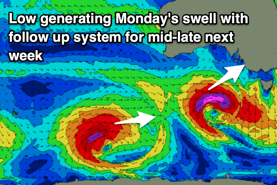
The freshening wind will be ahead of the next swell generating system, that being a deep, strengthening mid-latitude low forming just south of Western Australia during the weekend. The low looks quite intense with a fetch of severe-gale to possibly storm-force W/SW winds moving through our south-western swell window, producing a strong pulse of SW groundswell for later Sunday, peaking overnight and easing Monday.
With the low sitting mainly in our south-western swell window, the Mid Coast looks to pulse to 2ft later Sunday, easing from 1-2ft on Monday with the South Coast pulsing to 4ft, easing from 4-5ft Monday morning.
There’s room for movement in the size depending on the strength of the low but we’ll review this Friday. Winds look favourable for both coasts Sunday morning, N/NE Monday morning, but we’ll have a clearer idea on this Friday.
Beyond this a good, reinforcing SW groundswell is on the cards for later week but with winds from the south-eastern quadrant.
Comments
SW Ground swells....rare as hens teeth these days
Sure to see surf comps taking over surf spots again.