Big, bigger, biggest: inbound swell from STC Gita ahead
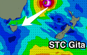
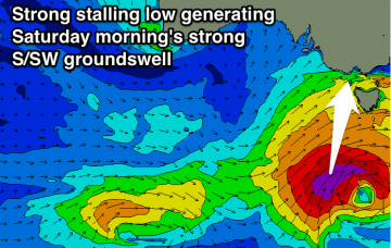
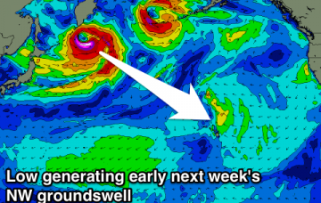
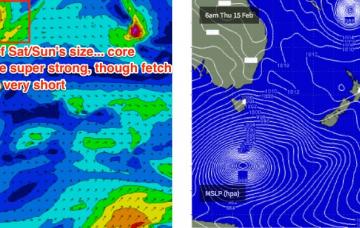
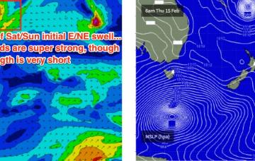
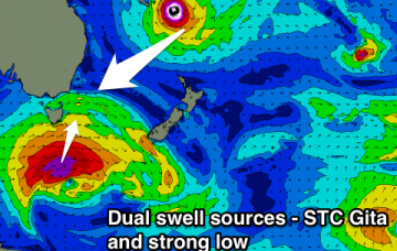
Relative to this particular swell window, STC Gita is an unprecedented weather system from a surf forecasting point of view.
Slow inconsistent increase in NE swell from Friday, growing through the weekend and likely biggest early next week. Strong S'ly groundswell in the mix Saturday.
New W/SW swell with westerly winds tomorrow with a stronger increase in SW swell through Friday, large late, clean and easing rapidly Saturday.
Easing S/SW swell tomorrow, further Friday with favourable winds. New inconsistent SW groundswell for Sunday with offshores, then some small new W/SW swell Tuesday next week.
Solid mix of SW swells tomorrow, more S/SW into Friday with a final S groundswell pulse Saturday morning. Favourable winds for both regions tomorrow, best on the Mid Friday and then South Coast Saturday.
Lots of W/SW swell with favourable winds for the Surf Coast over the coming days, with a strong S/SW groundswell Saturday morning, clean across most breaks. Easing surf with decent winds for the Surf Coast Sunday morning.
Easing NW swell on the North Shore with some reinforcing energy for Wednesday, smaller into the end of the week and weekend. Fun new swell for early and later next week. Good NE trade-swell for Micronesia and PNG with a N/NW groundswell later next week.
STC Gita is a very large, dangerous system that will likely reach Cat 5 this evening and persist at this strength for the next few days.
So, enough waffle.. how big is it gonna get?
Besides a small N'ly windswell pulse during the morning Wednesday, tiny ahead of slowly building levels of NE groundswell from Friday, more so through the weekend from STC Gita.