Fun swells though nothing to large for the coming fortnight

Hawaii North Shore, Micronesia and PNG forecast by Craig Brokensha (issued on Tuesday 13th February)
Best Days: Hawaii - every day over the coming period, Micronesia - this afternoon through Saturday and then Thursday next week, PNG - Every day from Thursday
This week and next (Feb 14 - 23)
Hawaii: Following an easing trend over the weekend, we've got some new large NW groundswell fill in this afternoon and evening with sets to 6-8ft across the North Shore.
The swell is expected to ease back through tomorrow from the 5-6ft range with S'ly winds.
The storm generating today’s swell has stalled north-northwest of us while generate a fetch of N'ly gales just within our swell window.
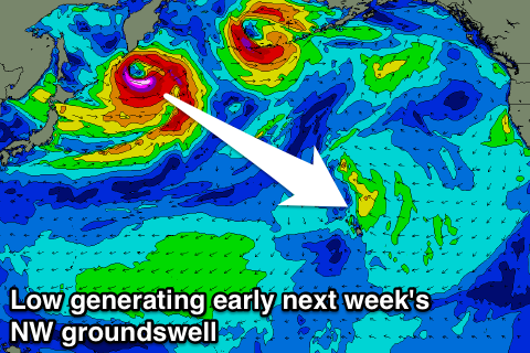 This should produce a reinforcing NW swell for Wednesday coming in at just over 6ft through the morning before easing into the afternoon and from the 3-5ft range Thursday morning, small Friday.
Winds will hold out of the S/SW on Wednesday but without too much strength, creating favourable conditions with less favourable W/SW winds on Thursday, back to the SW Friday and variable Saturday.
Besides a small pulse of background NW groundswell Friday afternoon through Sunday in the 4ft range at swell magnets, our next noticeable swell is due through early next week.
A very strong low spawning off Japan will direct a fetch of severe-gale W/NW winds through our far swell window before tracking north-east across the Aleutian Islands.
Due to the large distance from the low to our region, there'll be a lot of swell loss, but long-period forerunners are due in overnight Sunday, with the swell building through Monday and reaching 4-5ft+.
The swell is expected to ease from a similar size Tuesday morning and we're looking at generally variable winds, offshore each morning with weak afternoon sea breezes.
The swell will continue to ease Wednesday ahead of some new long-range NW groundswell later Thursday and Friday. This will be generated by a similar but more pro-longed low off the Japan coast, resulting in a larger swell that's likely to peak more around 6ft, if not a touch bigger. We'll review this Thursday though.
North Shore Forecast Graph
North Shore WAMs
Micronesia: This afternoon we should be seeing some solid NE trade-swell building across reefs open to north swell but out of the trades, with sets due to reach 3-5ft by dark, holding tomorrow with surf more to 4-5ft Thursday before easing from Friday.
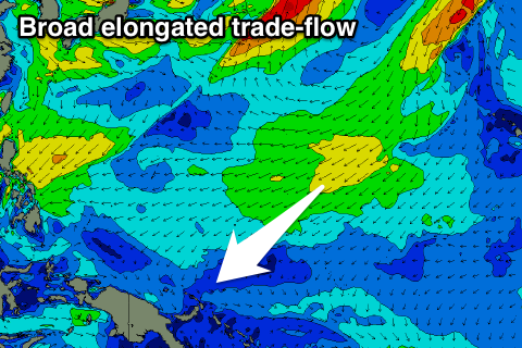 This will be a result of the broad and sustained trade-low to our east and north-east weakening slowly over the coming days.
The secondary low spawning off Japan should provide some fun but inconsistent N/NW groundswell for Thursday next week, with the first low forming a bit too far east and tracking north-east.
We should see inconsistent sets to 4-5ft next Thursday with favourable E/NE trades, but we'll confirm this next update.
Palikir Pass Forecast Graph
Palikir Pass WAMs
Papua New Guinea: Small surf the last couple of days but from tomorrow and more so Thursday we'll see the NE trade-swell building and reaching the 4-5ft range on the sets into the afternoon, holding Friday and then starting to slowly ease through Saturday.
Light to moderate W/NW winds over the coming days will tend more variable from that direction from the weekend, more so into next week.
The N/NW groundswell due Thursday across Micronesia is due Friday in PNG, providing inconsistent sets to 3ft.