Slow period after today's swell drops
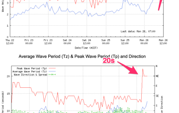
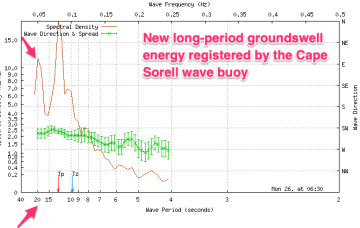
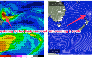
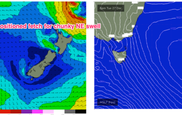
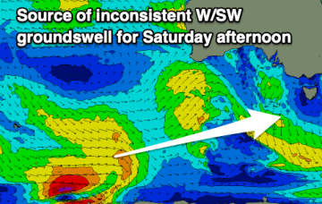
Today's swell will drop over the coming days and conditions will be best in the mornings ahead of a change Wednesday. Following this the outlook is slow.
We’re now on the cusp of a dynamic, tropical induced blocking pattern with low pressure hiving off an active monsoon trough in the Coral Sea and meandering in Coral Sea before drifting down into the Northern Tasman. The high pressure belt holds good support for this low pressure area with reinforcing cells stacking onto a slow moving system located at South Island latitudes. This will see an extended E’ly swell event, with days of pumping E/SE swell ahead.
The high pressure belt holds good support for this low pressure area with reinforcing cells stacking onto a slow moving system located at South Island latitudes. Eventually this large low pressure system drags a board fetch south enough to send useful E/NE swell to NE Tas.
We’re now on the cusp of a dynamic, tropical induced blocking pattern with low pressure hiving off an active monsoon trough in the Coral Sea and meandering in Coral Sea before drifting down into the Northern Tasman. The high pressure belt holds good support for this low pressure area with reinforcing cells stacking onto a slow moving system located at South Island latitudes. This will see an extended E’ly swell event, with days of pumping E swell ahead.
Fairly average conditions tomorrow, improving mid-week with a new swell and better winds.
We’re now on the cusp of a dynamic, tropical induced blocking pattern with low pressure hiving off an active monsoon trough in the Coral Sea and meandering in Coral Sea before drifting down into the Northern Tasman. The high pressure belt holds good support for this low pressure area with reinforcing cells stacking onto a slow moving system located at South Island latitudes. This will see an extended E’ly swell event, initially favouring sub-tropical areas and then spreading south to temperate NSW later this week.
Our large, long-period W/SW groundswell has hit Kangaroo Island and is on the way.
The new, long-period W/SW groundswell has hit Cape Sorell and we should see step-ladder sets developing from late morning.
By Boxing Day the broad blocking pattern will be setting with a dominant, slow moving high in the Tasman and low pressure expected to form along the monsoon trough line in the Coral Sea and in the South Pacific near the North Island. That will see at least dual swell producing fetches aimed at the Eastern Seaboard.
The high in the Tasman does set up a more local NE fetch though, with some chunky NE swell expected to develop Mid week.